


In recent years Architecture, Engineering and Construction (AEC) have begun to adopt 3D laser scanning as the method of choice for documentation of the built environment. The introduction of sophisticated 3D modelling and BIM has helped the industry increase productivity, enhance accuracy and reduce costs – technology that has advanced AEC and helped users deliver greater value to their customers.
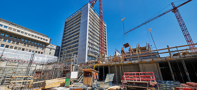
One of the greatest challenges of working in the AEC industry is measuring older spaces with no floor plans or cross sections, as well as trying to acquire elevational and floor-flatness information with outdated tools. Now, ultra-accurate 3D laser scanning combined with high-definition imagery is enabling entire environments to be captured and measured quickly, whether they are small intricate spaces or large dynamic sites.
Once users are introduced to the power of 3D laser scanning, they never look back. We’re sharing our top five tips to maximise planning, data capture and delivery to the client; advice that will guarantee success when utilising the latest 3D laser scanning solution: the Leica RTC360.
1. Get the knowledge
Effective building documentation begins with establishing sound knowledge; specifically, knowledge of your standards, your deliverables and your site.
Firstly, your standards define the way your company acts, which in turn builds trust in your brand. They are guidelines that describe your technology, quality, performance, safety, terminology and procedure. Standards are the fundamentals of any project.
Good planning is essential in expressing your standards and key to capturing laser-scan data efficiently in the field. Consider:
- What your purpose is with the laser scanning
- Who will be using the scanner
- What capture settings you should use
- The requested level of accuracy
- The photo requirements
- Whether you need on-site control for survey-grade accuracy.
Knowing your deliverables is also vital since deliverables drive success on each project. Leica Geosystems strongly believes in the phrase: ‘The process of the deliverable is in the roadmap used to get there’. This means ensuring:
- The scope of your project is well defined
- The site requirements have been evaluated
- Your captured scan data can be integrated into your customer’s software.
You should also have a solid digital strategy, making sure you have the right software to complete the deliverables that are required.
Leica Geosystems has new software tools to accomplish tasks depending on your workflow. Our floor flatness and floor levelness (FF/FL) tool (available in both Cyclone and CloudWorx products) can produce elevation maps to quickly QA any surface, helping you deliver smarter reporting with minimal effort.
Lastly, knowing your site is critical in defining your project. Understand the scale of your site – be it small, medium or large – and the different perspectives within that space; make sure you’re capturing from the right positions and at the correct resolution. You should also consider the daily patterns of your construction site (such as crane movements) and factor in any safety concerns.
Once you have this knowledge, you are ready to create an on-site plan to (a) maximise your time on-site (b) limit safety risks and (c) return to the office with all the data you need to get the job done right first time.
2. Pick the right instrument
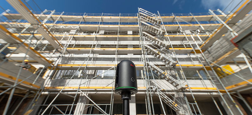
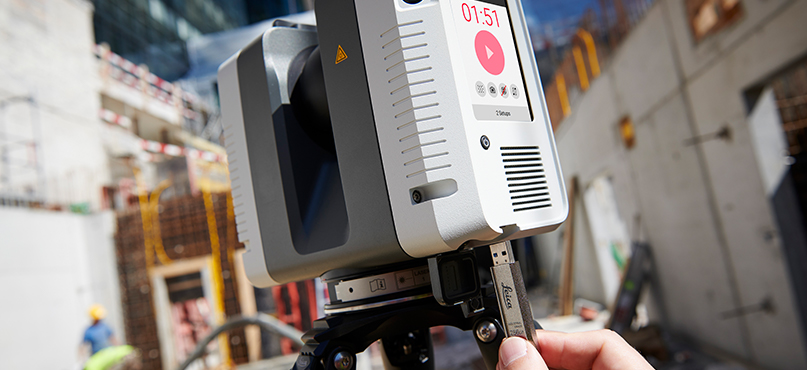
Picking the right instrument is critical to your project. You must understand the capabilities of your instruments and decide which one can deal with the task at hand. Consider your ranges and tolerances, as well as the speed of scanning and automation power. Also think about scan control, resistance to climate and the features of the entire laser scanning mechanism. You can compare Leica Geosystems’ hardware specs here.
For example, the Leica Cyclone FIELD 360 app is part of the Leica RTC360 3D Reality Capture Solution, which enables you to deal with information directly in the field in a fantastic new way – allowing you to pre-align your data, add imagery, take dimensions quickly and tag this information within each scan. Furthermore, the filtering system with its double-scan cleaning is outstanding: if you have a busy site with moving objects, the laser scanner will clean up anomalies between two scans, automatically filtering data.
The Cyclone FIELD 360 mobile-device app works with the RTC360 scanner and is now compatible with the Leica BLK360 too.
3. Planning for auto alignment
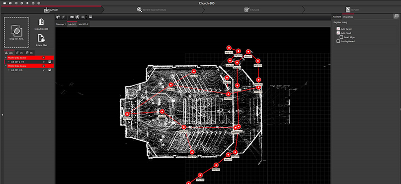
Auto Align is the process of taking scans and pulling them together based on common, relatable features or geometry. It can be used within Cyclone REGISTER and Cyclone REGISTER 360 point cloud registration office software. Once unique areas are identified, the setups are aligned before Cloud-to-Cloud registration is run on this alignment (where neighbouring scans are merged automatically); the setups are then registered. Auto Align can be run on any number of setups at once – each setup will be compared to the rest to find matches.
Typically, scans within buildings or scans that have clear vertical structures near the scanner, such as walls and building faces, are suitable for Auto Align. Outdoor environments with little topography, such as fields, and identical environments with repeating patterns, such as large warehouses, will make Auto Align difficult.
Auto Align and Cyclone FIELD 360 are different in that Auto Align uses geometry and doesn’t create links out in the field, while Cyclone FIELD 360 creates links as you go based on the movement of the scanner. From a system approach, the RTC360 solution combines a high-performance laser scanner, in-field alignment and QA, and a powerful office solution in Cyclone REGISTER 360, to deliver high-quality data efficiently for downstream use in various design platforms via CloudWorx.
4. In-Field registration best practice
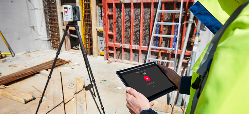
How does the Leica RTC360 work? Essentially, the laser scanner ‘sees’ its environment. The RTC360’s unique Visual Inertial System (VIS) consists of five cameras and one IMU that track the movement between two consecutive setups in real time. Users can preview point cloud data on their tablets, check pre-aligned point clouds, add tags, then take it full circle into the registration programme.
In terms of setup and planning, users don’t necessarily need to have overlapping geometry as the technology will track you wherever you go; however, overlap is recommended for optimum results with VIS technology. It’s also recommended to increase the resolution in outdoor environments to give Cyclone FIELD 360 more data for joining scans. The recommended distance (ds) between setups depends on scan resolution:
- Low resolution ds = 5-8m
- Medium resolution ds = 10-15m
- High resolution ds = 20-30m
Leica Geosystems advises creating manageable project sections in Cyclone FIELD 360: keep things simple by having 20 to 25 setups per job. Multiple jobs can be combined into a single project; there is little advantage in keeping all setups in a single job.
5. Data storage best practice
Data is being collected more and more on sites today, which means data storage should be a high priority for laser scanner users. Backing up information is vital: store RAW files on large storage disks (10+ TB) under a file-naming system that works for you. Use redundant RAID setups for disks to ensure data integrity, and a temporary directory that is on a different disk than the one for project storage.
With Leica Geosystems’ Universal Project file (LGS), users have total flexibility to exchange data from Cyclone between all Leica Geosystems laser-scanning software. This is a simple, portable file-based system for all your digital-reality scan data, replacing disparate formats for different cases. LGS files are published solely by Cyclone PUBLISHER Pro.
Within this one consolidated format, the data stored will include project metadata, project SiteMaps and setups, and point cloud and geotags. All this information will be captured and held in one place. LGS is an intuitive way to share files externally and is compatible with all our software platforms, such as CloudWorx, TruView and JetStream.
To find out more about the Leica RTC360 and learn the best practice for building documentation, watch the in-depth webinar by Clair Vander Zwagg, Reality Capture Manager at Lecia Geosystems.
Michelle Byrne Senior Marketing Communications Manager, Terrestrial Laser ScanningGlobal Product Marketing Communications, Reality Capture Division