This week’s Leica Captivate Education series has invited Alastair Green to explain a bit about the new upcoming Inspect Surface app, due to be released November 30th. And as Alastair puts it: It’s simply brilliant! Read more to find out why….
With Leica Captivate v1.30, a new app will be released – the Inspect Surface app. Can you tell us something about this app please?
Simply put, the Inspect Surface app is brilliant! As the name suggests, it allows a user to inspect a surface.
What this means is the following…
Firstly, the user defines a reference surface, that is, the design surface or what the surface should be. This could be as simple as one point defining a horizontal plane – for example, the level to which a concrete floor should be poured. The next step is then to compare reality – the true measurements of the surface to this design. For instance, the concrete floor could have been scanned with an MS60 MultiStation or measured with a normal total station. This measured “reality” is then compared to the design. The user can then view the surface with a colour scaling which identifies the difference between reality and design.
In the screen shot below exemplifies this quite nicely: A concrete floor has been scanned and compared to the true design. Of course the concrete was not poured completely flat so there are hills and valleys. In the image below the blue areas indicate where the floor is lower than it should be, the red areas are higher than it should be.
Below you can see the user has tapped in the red area and you can see this area is 4.9mm higher than it should be.

OK – but then how can the user indicate to the foreman the areas of the floor which need reworking?
Easy! From the pop-up menu choose Turn to point and the instrument will turn to the selected point – the red laser of the instrument will then clearly show the foreman where to do the remedial work.


Sounds great – no need to go back to the office?
Exactly – this is the power of this app. It allows decisions to be made in the field.
Imagine how much time and money this saves. Previously the user would needed to have measured the concrete floor, gone back to the office, load the data into an office software, analyse the surface, somehow print out the results and then return to the site and somehow indicate to the foreman the areas which need re-work. This is now done in seconds…
What other use cases do you think users will find?
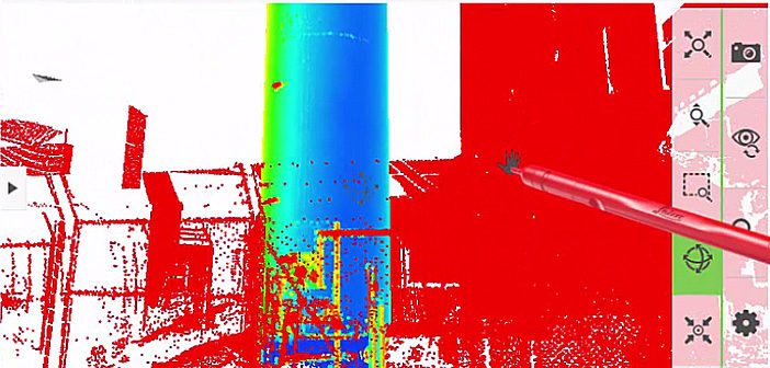
I think our users will find more than I can think of! But I could imagine the checking of vertical walls, checking the positioning of silos, checking dam walls and many, many more – in all cases, lots of time will be saved. Look at some examples below.


Which instruments can use this app?
The app is only available within Leica Captivate, not for SmartWorx Viva. It can run on the CS20 field controller, the CS35 tablet and on-board the TS16, TS60 and MS60. If you run the app on the CS20 or CS35 then the app can be used with any total station to which the CS20 or CS35 can connect.
So this app is not only for MultiStations?
No, all total stations can use the app – simply measure points in the normal way and compare these measured points with the design surface. But of course, it is a lot faster to measure a lot more points with an MS60 MultiStation.
How can someone find out more about this app?
Best way to find out more is to watch the below video.
Do watch it all the way to the end – it covers 4 use cases – but as I said, I am sure users will find many, many more…
Thanks for your time!
Best regards,
Alastair Green

Alastair Green, business director of field measurement software and field controllers at Leica Geosystems


