


Reality Capture with the Pegasus:Backpack for as-built conditions in large buildings
Wearable, rapid and mobile. These are only a few of the reasons why Multivista, a world leader in construction photo and video documentation, is pioneering the use of Leica Pegasus:Backpack to capture and visualise large building projects.
Benefitting from the Pegasus:Backpack’s speed in both data acquisition and processing, Multivista is exploring the use of Leica Geosystems’s mobile mapping platform on large building projects in Las Vegas, United States.
Brian Smith, product manager of emerging technologies at Multivista, during HxGN LIVE 2018 gave a presentation on how reality capture mobile mapping technology can be applied to collect data on existing building conditions. Along with practical examples, Smith also gave best practices and tips to how to use the Pegasus:Backpack efficiently.
“The Pegasus:Backpack is an amazing piece of hardware that is a testament to Leica Geosystems’s engineering and software ingenuity,” said Smith.
Mapping indoors, outdoors, anywhere
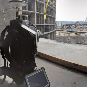
 The Leica Pegasus:Backpack combines five cameras offering fully calibrated 360 degrees view and two LiDAR profilers with an ultra-light carbon fibre chassis. It enables accurate mapping where GNSS position data is unavailable, such as in large buildings.
Besides leveraging the position-independence of Pegasus:Backpack, Multivista took advantage of:
- Rapid data collection
- Creating complete and measurable LiDAR datasets
- Visualising complex datasets
- Quickly adapting to new environments and places.
These features enabled Multivista to achieve time critical analysation of existing building conditions at the construction of the Resorts World Las Vegas and the Fontainebleau casino resort complex.
Analysing existing building conditions with mobile mapping
Over 100,000 square feet (sq ft) of gaming space and an elaborate Chinese-themed garden would attract the future visitors of the Resorts World Las Vegas casino complex. However, the construction stopped in 2010. After many delays, the project has begun again in late 2017 but there was no up-to-date information and documentation of the unfinished building. Therefore, Multivista experts were requested to capture the building complex and develop a 3D model of the existing conditions.
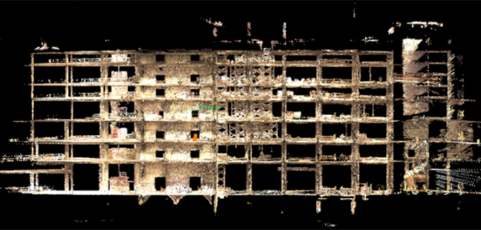
The Leica Pegasus:Backpack enabled Multivista to collect data faster, and to develop more comprehensive 3D views and analysis of the:
- 3,400 hotel rooms
- 10,000 sq ft casino
- 3,200-seat theatre
- 150,000 sq ft of convention space.
The data collected with Pegasus:Backpack is used to fill the information gap left by incomplete, old, or inaccurate as-built data of the resort and helped stakeholders to make more informed decisions.
Gaining a better understanding of the as-built environment
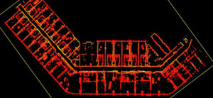
The Fontainebleau Las Vegas casino complex was announced in May 2005 with initial plans to open by 2008. Construction work stopped in 2009 and started again in 2018. Due to the delays, information of the as-built environment and the original plans were lost. To begin the construction work, Multivista was requested to collect the existing as-built data of the 68-storey high-rise.
With the Pegasus:Backpack, Multivista experts captured more than 4,000 rooms, the spherical images helped the customer understand the various floors and their different state of completion before starting the construction work.
Best practices for indoor reality capture
After deploying the Pegasus:Backpack in several indoor surveying projects, the construction technologist, Brian Smith, collected the best practices and tips capturing existing building conditions:
- Test the Pegasus:Backpack before arriving at the site
- Walk around the site before beginning the mission (access, familiarise yourself with the environment)
- Identify two stairwells on opposite sides of the project to walk up and down
- Walk in paths that overlap and figure 8’s to maximise alignment for SLAM (Simultaneous Localisation and Mapping)
- Following a routine is the only way to ensure consistent quality results.
Mobile mapping differs from static, terrestrial laser scanning, as the Pegasus:Backpack captures the surrounding while it is being moved in the scene. Familiarising with the environment before using the Backpack and following an assigned route, helps consistently collecting quality data.
With the Pegasus:Backpack, Multivista experts captured large, difficult to access construction areas from a safe distance, faster than traditional survey or laser scanning methods. Integrating the results with Multivista´s image viewer helped the customers gaining a better understanding of the as-built environment and enabled them to make more informed decisions before the constructions would have started.