


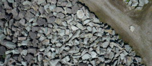
To make informed decisions based on your data, you need to trust the survey data you collect. When you capture UAV data for photogrammetry, the needs for the images are different from when taking aerial overview images or doing an inspection flight. Highest accuracy results come from high-quality images. That’s a no-brainer, right?
Photogrammetry needs flat, low contrast, sharp and in-focus images. You get them with a correctly focused lens, slightly underexposed images and even lighting conditions. However, accuracy does not only depend on the image quality. What should you know before you capture your data? Below is a list with the things you need to keep in mind when you are collecting UAV data for photogrammetry:
Make your photos look sharp and clear
Finding and matching features from blurry images is hard for photogrammetry software. Basically, if the feature isn’t visible in the image (or it’s blurry), it cannot be matched. Here are some tips to help you avoid having blurry images
- Flight speed: A good rule of thumb is to fly less or equal to 5m/s to take sharp images. The optimal speed of course depends on the flight height, your sensor and the light conditions (possible shutter speeds).
- Depth field: Having a deep depth field allows all the objects of different height to be equally in focus in under the camera. Still, remember not to overplay it – too high number means less sharp images. Most recommended f-stops are f/5.6-f/8.0 but still depends on lighting conditions.
- If you have adjustable focus on your lens, set it to near infinity. Usually far infinity means less sharp images.
If you just could affect the weather – Avoid deep shadows
One might think that bright sunny day with blue skies offers the ideal conditions for data collection. Stratus cloud cover is the best lighting condition as there are usually no deep shadows, but still adequate lighting for images. Light even cloud cover is best, as it diffuses the light. You will have even colours in all parts of the covered area, less reflection and softer shadows with fully covered skies.
If you are flying in a bright daylight, try to time it between 10am and 2pm to take advantage of high sun angle and avoid long shadows. Remember that if you have a large area to cover and process, the weather conditions should be consistent throughout the whole collection time for best results.
Choose the right lens and adjust it – It matters more than you would think
Choosing a right lens for photogrammetry could be a blog post on its own. Choosing a high-quality lens that has less distortion and the right qualities makes a difference in the end result.
Even if your lens has autofocus, choose manual focus for photogrammetry as all the images in the flight should be taken with same parameters.
Prepare you flight plan – And adjust it if needed
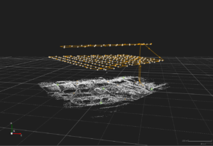 If you need high accuracy in your results, fly two flights over the same survey area to make the photogrammetric block stronger. The flight lines should be perpendicular to each other and on different heights. The second one being ±1.5x the original flight height. During the second flyover, you don’t need to cover the whole area, two to four flight lines are enough.
Don’t save time in overlap; It might feel tempting to have less overlap to cover a larger area on the flight time you have but the more you have overlap, the more the photogrammetry software has options to match features. A good rule of thumb is to have same overlap on side and front and it should always be more than 60%, preferably 80%.
Make final adjustments to your flight plan when you know the flight conditions. If the weather is bright and sunny, you can fly faster as the shutter times can be shorter. But remember, if you are repetitively collecting the same data for comparison over time, it might be better to always fly with the same plan and parameters.
Ground control points are always a good idea – In search for higher accuracy
If you need high accuracy in your data, measure and use ground control points (GCPs) even if you are flying a UAV that has survey-grade GNSS integrated. GCPs can help resolve many camera ambiguities such as focal length and distortion model problems.
Aim for at least four GCPs with five 5 GCPs being the optimal amount. Add more than 5 GCPs if the area you cover is large or varies highly in height or shape. Three is also doable but it is tricky as they can cause bad geometry in the photogrammetric block. This depends on the shape of the area you are flying – three might be enough if your area is a triangle. Two control points is too little as they form a line and the point cloud can turn in space around it.
Choosing the places of the GCPs isn’t quite trivial; they should be evenly distributed by position and height representing the area as clear as possible. They should be placed under the flight lines if possible, and be on a flat area that is clear from vegetation and well visible from the sky.
In addition, to the GCPs you are using for controlling, measure at least three check points to ensure your data is as accurate as it should be.
In the end, collecting data is easy and flying is fun but knowing that you can trust the results and you got the results you were after is all that matters. Take your time creating the flight plan, choosing settings and finding the right conditions and you will be pleased seeing the results.
If you want to know more on good quality your data collection, contact your Leica Aibot representative. Leica Geosystems has a UAV solution that has been designed for professional use. For more information on the workflow and solutions click here
Anne Pitkaenen
Product Marketing Manager UAV