


The tracing and mapping of utilities is an essential part of any project looking to build on a site, whether it’s for the design team to find utilities to connect with or for avoidance for the ground workers to excavate safely. This can be a time-consuming effort taking it from plan request to producing an accurate detailed map of the utility network below ground and varies dependent on how big a site is and how many utilities are present.
This is workflow will consist of:
- Statutory records investigation in office
- Manhole inspections on site
- EML tracing of metallic utilities
- GPR acquisitions on site
- Survey all located utilities
- Post process GPR findings
- Integrate all findings to one map
Utility surveyors undertake this kind of project all the time and the steps involved have changed little in the past half-century. However, over the past few years the technology and software available to achieve this have improved to a point where they can deliver big efficiencies.
The hardware
When we talk hardware in utility surveying we are talking precision electromagnetic locators (EMLs), GPR, positioning equipment and all the tracing accessories. Some of this equipment has come a long way in recent years. With the precision EMLs we have seen a jump from basic avoidance tools to more powerful and informative tracing equipment with inbuilt Bluetooth and GPS. These new smart devices are capable of linking to tablets, smartphones and more accurate positioning equipment to log serious amounts of data.
Improvements in GPR equipment has mainly been in the area of data transmission from the GPR device instantly to the device’s own onboard tablet. Now the data viewed on the tablet can be marked in real time, to produce onsite reports based on overlaying data to satellite images or open maps. The link to precise measuring such as GNSS and TPS allows all data captured to be georeferenced for future works that may need the sites utility plans.

Leica Geosystems Detection Systems
The software
Recent developments in software have been where the real time-savings can be found, moving the industry from heavily paper-reliant to almost paperless, introducing real-time data transfer from site to the office and improving maintenance workflows beyond recognition. This real-time integration has improved and speeded up the post-processing of site data massively, as well as streamlined site management by introducing the ability to project manage all elements of site paperwork in one central database.
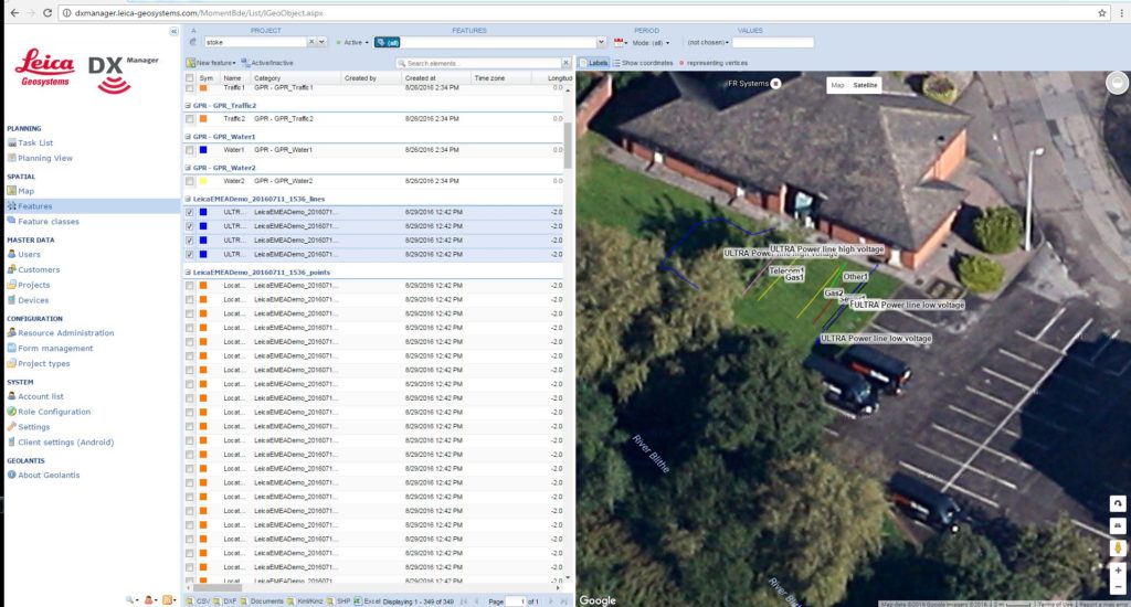
View of DX Manager
Using DX Manager for Mapping means just by taking a depth to a utility, an automatic process starts by actioning the target to be coded and displayed in the office immediately. This eradicates any time delay in coding, resurveying marks and travel time. This real-time approach links the data from EML, GPR, positioning and cameras all in one project that can be analysed and exported in all common formats for CAD technicians or GIS platforms.
These mapped areas can be made accessible to view for all site workers on their smartphones or tablets, keeping them up to date and not relying on someone to create the correct paper plan. All information gathered from the mapping phase including photos and details down within the palm of the worker’s hand.
Moving forward in the process, the development of real-time data transmission from site to office means that the post-processing task of the project can begin before the surveyor has even left site, by their colleagues in the office.
The project can then also be updated and added to within DX Manager over time, meaning that your maps are up-to-date, available centrally and when using Leica equipment – accurate.
Add to this the digital forms for manhole inspection, method statements and procedures the site can become predominantly digital through one central software.
For more information on our detection equipment and software, visit the detection section of our website.
In fact, we can go a whole step backward and take a look at how they know what site to go to. With the introduction of tasking within the system, it becomes a project management tool with task assignments linked to specific jobs including where it is, what needs to be done and who should go.
Moving forward in the process, the development of real-time data transmission from site to the office means that the post-processing part of the project can begin before the surveyor has even left site, by their colleagues in the office.
The project can then also be updated and added within DX Manager over time, meaning that your maps are up-to-date, available centrally and when using Leica Geosystems equipment – accurate.
For more information on our detection equipment and software, visit the detection section of our website.
https://leica-geosystems.com/products/detection-systems