


The city Gothenburg, the second-largest city in Sweden, lies along the Göta River estuary. With an almost-sea-level height, the city is flanked by water and partially built on clay ground. Parts of the town have more than 100 meters of clay, which makes piling mandatory in any construction work.
As piling starts, the clay-based ground begins to move; attributed to the volume of the piles which displaces and moves the clay. Movements of 50 – 100 mm are not uncommon affecting both plane and height of buildings. These movements also create problems for surveyors as their fixed points are continually being moved around by the piling works. These movements force surveyors to remeasure the network of fix points constantly – a time consuming and expensive process.
As expected, the movements of the backsight also caused problems for the automated GeoMoS monitoring system. To solve this challenge a chief surveyor in one of the projects asked the Leica Geosystems TPS/GNSS/Monitoring support team in Sweden if the problem could be solved by adding automated GNSS post processing to the GeoMoS monitoring system. Our team installed four GNSS systems, solving the issues of moving prims.
Steps to set up the monitoring system at Gothenburg
Five monitoring systems have been set up between 2015 and 2019 in Gothenburg. With only 1 or 2 fix points in solid rock in most of the projects, the addition of GNSS post-processed fix points has become mandatory.
Under each GNSS antenna, a 360 ° prism was installed. GNSS Spider software provides automated post processing and Leica GeoMoS monitoring software collects the calculated points and uses the prisms under the GNSS antenna as backsights for the resection (free station). Realising these GNSS points could also be used as fix points for the surveyors, coordinates from GeoMoS were then also shared with surveyors so they could use the GNSS/360 prism as backsights.
The equipment used for establishing a reference point network includes:
- Leica GM30 receivers for monitoring
- AR10 GNSS antennae
- 360 ° prisms
- Leica GNSS Spider software
Using GNSS and 24-hour post-processing works well provided that, over time, movements are relatively small. For quicker movements, one can use shorter timeframes, but the accuracy then declines from mm to cm level.
-
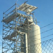
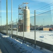
- The pictures show one of six pillars built, all of them with 9-meter height, 55-ton weight and spaced 300 meters apart.
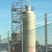
Each pillar is equipped with:
- Leica Nova TM50 monitoring total stations
- Leica GM30 receivers for GNSS.
- AR10 GNSS antennae
- Round prisms GRZ122 (MPR122 can also be used)
Then we asked ourselves– could we add automated network adjustment so that all prism, including the monitoring prisms could become potential fix point?
Leica Geosystems’ GeoMoS Adjustment is the software for this job as it adds automated network adjustment to GeoMoS.
The GNSS measurements, together with measurements to the monitoring prisms, are all collected by GeoMoS Monitor, which then automatically trigger network adjustment in the GeoMoS Adjustment software.
GeoMoS Adjustment then adjusts the coordinates of the prisms for the entire network and writes this data both to GeoMoS and to a CSV text file. For our use, the CSV file is what we needed. This file is distributed to surveyors who can now use any prims at sight as a potential backsight.
The adjusted coordinates can, of course, be used in the deformation detection but for us, the primary need was to get more backsights for the surveyors.
By adding GeoMoS Adjustment, each monitoring prism which belongs to this project can also be used as a backsight by surveyors.
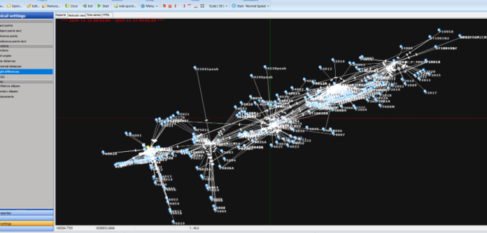
The image shows another network geared with six total stations and six GNSS antenna/receiver combination.
Two birds with one stone
In 2015 we had two issues to solve, caused by ground instability and moving reference points:
- Problems in surveying works due to moving backsights: This forced surveyors to remeasure the backsights constantly or to accept degrading accuracy.
- Problems in monitoring systems: With the movements of the reference points being projected to the monitoring points it was challenging to detect real movements.
The addition of automated GNSS post proccing to GeoMoS was a big step forward. This solved the pain of having to remeasure the fix points constantly.
The addition of GeoMoS Adjustment has increased the accuracy and significantly increased the flexibility of choosing backsight points for surveyors when performing resections in their daily work.
Surveyors in Gothenburg are pleased with the quality of the free-station coordinates since GeoMoS Adjustment was introduced. One project has been completed so far, but the others are soon to follow.
As of now, we have close to 30 GNSS systems (GM30, AR10, 360 prisms) in operation in Gothenburg with one project using 18 GNSS in one system.
Learn how our monitoring solutions can adapt to your project’s environment.
For more details and questions on the monitoring system created in Gothenburg, please contact frederick.somerville@leica-geosystems.com

Frederick Somerville
Leica-Geosystems
TPS/GPS/Monitoring support Sweden