


3D laser scanning technology allows surveyors to capture millions of 3D data points in minutes accurately. These combined data points, known as point clouds, provide a complete, clear and precise digital record – or ‘digital twin’. Having a digital twin based on accurate data provides surveyors with the ability to measure what meets and escapes the eye and visualise data in a variety of ways.
Don Smith, licensed professional land surveyor, senior project manager and principal with BL Companies, shares why his firm uses laser scanning and 3D field software, resulting in improved and collaborative workflows and immediate deliverable that its clients can visualise.
This blog extracts Smith’s five key benefits and provides you with the easiest way surveyors can get started with laser scanning.
-
Open a competitive advantage
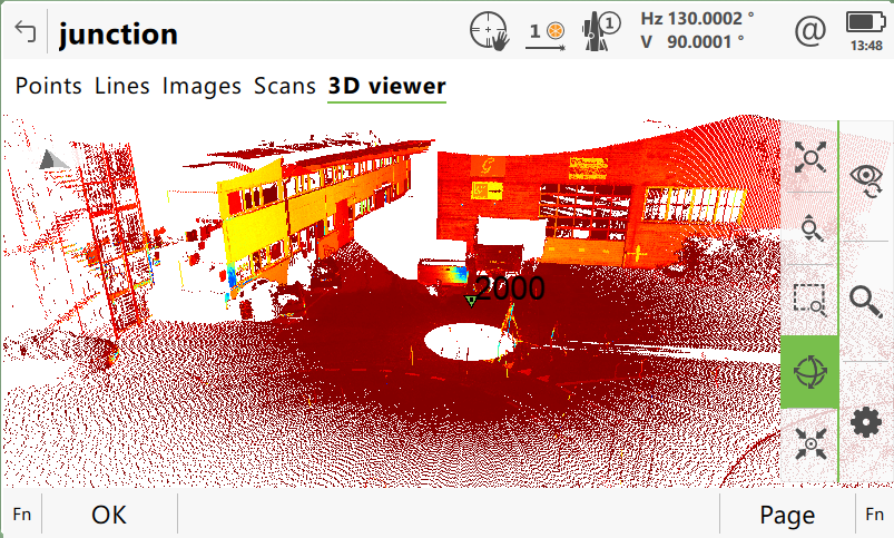
Point cloud collected with the Leica MS60 MultiStation displayed on Leica Captivate 3D viewer.
With a ‘digital twin’ of the captured reality surveyors can visualise data in a 3D environment. Data collected is processed to extract actionable information and create various deliverables that are used for multiple applications, opening the door for surveying companies to provide new services and higher value deliverables. Surveying companies that integrate laser scanning can also gain a competitive advantage through faster project turnarounds, improved safety and management.
“Only if we have done a really good job at reproducing that [recorded information]can we hope to understand the limitations that may be applied or opportunities or future developments and uses[…] The unmistakable shift to a 3D environment, a true 3D experience and design development platform has never been more realised than it is right now,” explains Smith.
-
Work collaboratively
As in many other fields, surveying companies have an increasing need to collaborate instantly. Working on 3D environments created with laser scanning brings collaborators through cloud-based software into one single 3D model that can be visualised to make decisions from anywhere on any device, bringing work functions closer together to improve workflows.
It is possible to virtually walk through the digital twin of the captured environment and take snapshots, make measurements, create visualisations and create mark-ups with tags.
“The need for us to be able to transform the way we work and how we collect and display our data[…] and have interactive communication with our clients, not just our colleagues, in a project management format and a client communications based tool. The need to shift towards this interactive collaboration based on this 3D cloud geometry has never been more important,” explains Smith.
How can surveyors get started with laser scanning?
Surveyors can get started with laser scanning with the workflows and apps that are familiar to them. Surveyors can use the Leica Nova MS60 MultiStation to perform traditional total station surveying tasks and easily scan at a speed of up to 30,000 points per second – all in one instrument. With a high-end total station that includes scanning, digital imaging and GNSS connectivity, surveyors can easily switch between angle and distance, reflectorless, imaging and scanning data capture methods – and merge all data into one dataset.
Combined with Leica Infinity, surveying companies can rely on their known seamless dataflow combining MultiStation, total station and GNSS data to complete valuable deliverables. With intuitive on-board Leica Captivate software, surveyors can also bring 2D and 3D digital design data into the field and at their fingertips, making informed decisions in a timely manner in the field. Surveyors can also enjoy point clouds that are already registered onboard the total station via the setup application.
The MS60 MultiStation features surveying-specific functionality for data collection for volume calculations and grids to measure, visualise and report deviations from a design object or a previously scanned surface.
Being familiar with the equipment allows field crews at BL companies to accurately capture more high-quality data in less time and reduce training time and costs.
“The Captivate touch software has been beneficial in a number of ways because it provides the software platform in which our total stations and our GPS units are able to interact. The menus are the same – they’re seamless. Once you’re trained on one, we very quickly pick up how to utilise it for the other pieces of equipment, including the MS60,” explains Smith.
The MS60 is a great starting point for users who haven’t scanned before and an easy way for surveyors to get into point cloud. For faster laser scanning discover our portfolio of terrestrial laser scanners.
-
Save time and increase productivity
Laser scanning is easier and faster than traditional methods and produces more comprehensive results. Laser scanners can create an accurate, as-built scan in a matter of minutes, instead of taking hours using more traditional measurement methods. With 3D laser scanning, it’s easy to get a comprehensive scan of a site and collect thorough accurate data in one visit, avoiding the cost of re-visits and increasing the safety of your team as they can collect data from a distance.
Beyond the fast, complete and accurate data provided, BL Companies also saves time using the same familiar workflows of the MS60 MultiStation and Captivate.
“The time savings alone with being able to have the same routines, and not using two different pieces of equipment with different software and different coding. The familiarity on all the pieces of equipment cuts down the time anywhere between 50 and 25%. Training is much more efficient for our crews and the consistency of integrating that same software to operate them – invaluable,” says Smith.
-
- Point cloud captured with MS60 visualised on Captivate.
-
- Point cloud captured with MS60 visualised on Infinity.
-
Visualise data
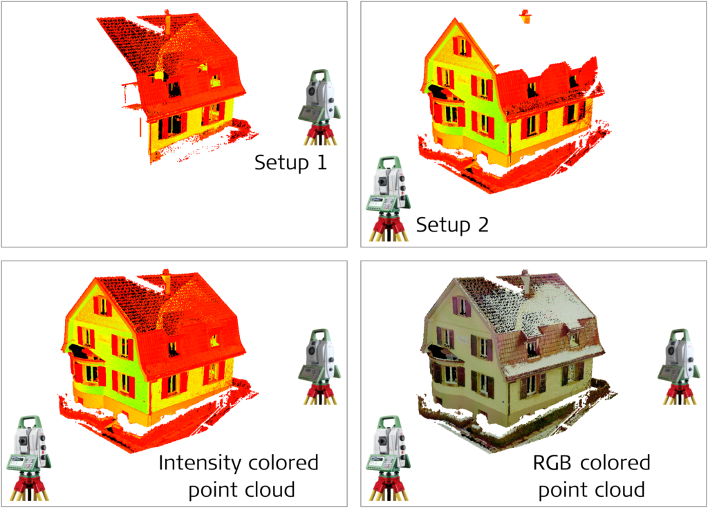
This collage shows the point clouds are already registered when traversing around a house and form a complete geo-referenced model directly in the field, displayed with intensity values or in true colour.
With visualised data to measure, create plans, track and share progress with key stakeholders, projects are more efficient and productive. Laser scanning allows to visualise data in the field and share it with project collaborators in real time. Data can also be viewed in CAD packages to develop as-built drawings and extract any features to create a wide variety of deliverables. With the ability to access data remotely, exposure to potential hazards is minimised, ensuring the safety of crews.
Besides having an accurate point cloud collaborators can visualise, BL Companies has all surveying data in one place, GNSS and TPS information included, into the same dataset.
“The overlay of the scan data on top of our traditional field locations, whether it’s from the total stations or the GPS receivers is one of those immediate deliverables that are our clients can see what we’re doing. With the scan data from the MS60 you’re able to graphically show the same day it’s collected the locations in the field to any layperson,” tells Smith.
-
Increased communication and accountability
Added costs, progress on the project, meeting deadlines and quality of the services are some of the concerns surveyor’s clients may have. Laser scanning provides the foundation for a 3D digital twin that clients can easily navigate and walk-around the site, providing a rich visual to discard any concerns and build trust. Having an accurate digital replica -or digital twin- throughout the lifecycle of a project enables digital access to any captured site, avoiding revisits, cutting travel costs and making it easier to work with contractors based off-site.
“They [clients]want to make sure that what they’re investing in is in your service. ‘Are you providing it? are you delaying my project? is it going to cost me money?’ those are their concerns. When you have an increased level of communication with them and a deliverable they can see – you’ve just got a repeat client,” concludes Smith.
Click here to learn how you can grow your business with laser scanning.
Or visit our e-learning page to get started with laser scanning.