


As governments and organisations seek to mitigate the effect of the pandemic on their economies, construction companies adopting integrated digitalised solutions are powering a transformative change across the world.
With the pace of transition accelerating to support economic recovery, companies investing in innovative geospatial technologies and processes are positioning their businesses to deliver complex projects on time, on budget and within specification.
Budget overruns – worldwide – are one of the construction industry’s greatest challenges. According to Forbes, China’s Three Gorges Dam, for example, was 163% over budget, but overspends are not limited to Asia.
The pressure on businesses to stay competitive, by demonstrating greater cost-effectiveness in their work practices, is likely to increase in the wake of an economic slowdown.
In a recent report, the McKinsey Global Institute predicts a $49 trillion investment in civil infrastructure will be needed by 2030, just to keep pace with global demand.
With governments and stakeholders taking the opportunity to further invest in transformative urban construction and smart city technology over the next 10 years, companies using advanced, digital geospatial solutions will be well placed to withstand the impact of any future disruption.
What steps can construction companies take to stay competitive and productive in a changing world?
- Reduce errors and control costs
The use of Hexagon’s digital solutions, from design to completion allows the financial sustainability of a project to be tracked at every stage, providing the insight needed to make faster and earlier cost corrections.
Digitalisation also provides connectivity between office, field, and home working teams. Gaining instant access to a single source of accurate information avoids time-consuming, costly processes, especially when combining data from different devices.
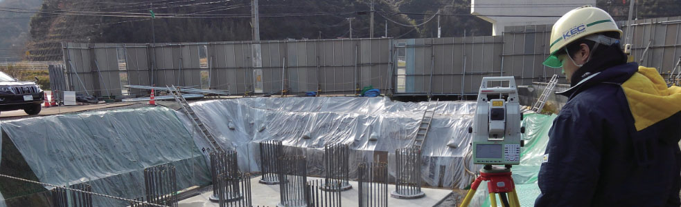
A consortium of four companies, led by Kanatsugiken, and invited by the Japanese Ministry of Land, Infrastructure and Transport (MLIT), undertook a trial as-built project, showing how innovative technology improves productivity and reduces errors on construction sites.
Kanatsugiken chose Leica Geosystems’ Leica Nova MS60 MultiStation, an instrument capable of 3D laser scanning and photography, with the surveying functions of a robotic total station. Concrete structures were scanned and the acquired point cloud data was used for as-built verification.
Using traditional survey methods, the as-built verification is time-consuming and labour intensive because much of the measurement and analysis of disparities is done manually, impacting on project costs. The consortium conducted field measurements and data analysis at five sites. The MS60 not only cut the manhours for the measurement work to less than half, but also reduced downtime significantly from 83.3 man hours to 37.27 hours, as compared to conventional methods and techniques.
- Increase remote offsite inspection
Working remotely has many benefits, over and above accessing site data. Teams can enable remote inspection processes to document existing conditions, keeping projects on track and to the correct quality standards.
With social distancing restrictions impacting on-site operations, digital solutions by Hexagon can keep businesses productive and their employees safe through the use of one-man reality capture devices.
Fast and efficient, laser scanners, mobile mapping devices and UAVs, together with a range of digital geospatial technology, including Building Information Modeling (BIM), can be used to create a precise digital replica of onsite conditions. Work can be documented in virtual inspections and as subcontractors and stakeholders have access to real-time information, informed decisions can be made whilst working remotely.
- Improve performance and profitability
Even before the current crisis, organisations have been using digital technology to collaborate, increase their productivity, and help them maintain the level of work amid a shortage of skilled workers.
Forward-thinking government initiatives, including Singapore’s Building and Construction Authority’s (BCA) Integrated Digital Delivery (IDD) implementation plan, are encouraging more built environment sector firms to go digital.
Digitalising workflows and automating processes, whilst also ensuring all stakeholders have access to dynamic, critical information, saves time, keeps projects costs down and reduces operational risk.
Digital geospatial technology enables teams to collaborate and stay productive even when social distancing restrictions apply and border controls limit the supply of personnel.
- Reduce health and safety risks
Reality capture solutions such as laser scanning, mobile mapping and UAV systems allow a single team member to gather site data quickly and accurately, minimising risks to personal safety.
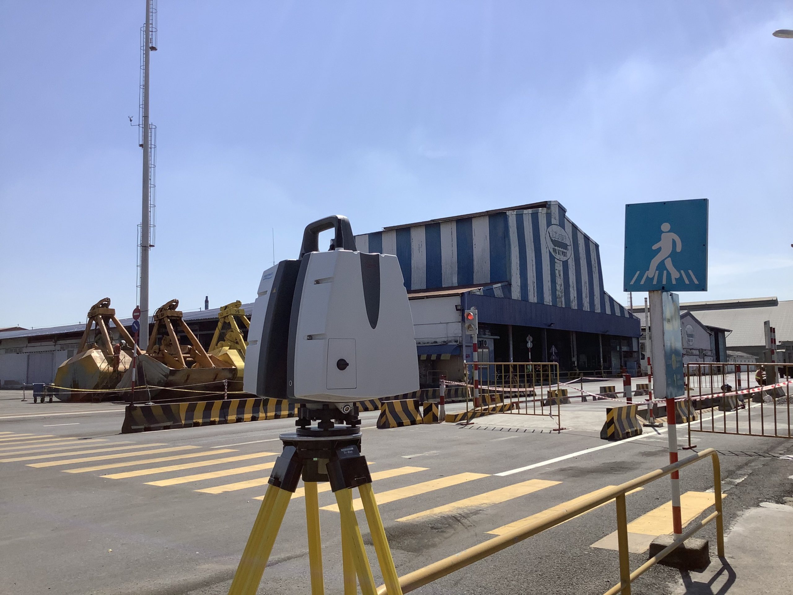
The busy cargo port, Phu My Port in southern Vietnam, operational 24 hours a day, required laser scanning to collect data for a 3D BIM model. Bringing a large team to a site increases operational risk, especially in rapidly changing tropical weather conditions, with heavy traffic areas.
Vietnam’s leading port and coastal survey consultants Portcoast had previously carried out pioneering work using the Leica ScanStation P50 for data capture at Hyosung Vina Chemicals Port, reducing the topographic survey time there from 12 hours to just three, and with less personnel.
At Phu My Port, Portcoast was commissioned to produce an inspection report for the 132-metre main berth and 72-metre long access bridge, along with 3D laser scanning the whole site to create a digital twin for ongoing inspection and maintenance.
Portcoast used the ScanStation P50 across large areas and the Leica RTC360 and Leica BLK360 laser scanners for 3D scanning the isolated and inaccessible areas under the berth. Rapid capture and transfer of data was imperative in the unpredictable and ever-changing tropical climate of the region. Using Leica Infinity and Leica Cyclone software, data transfer was immediate so both office and field teams could view and process in real-time.
Portcoast built the point cloud model for the whole port incorporating all the information from each element into the BIM model. The accuracy of data capture allows the project to be viewed through VR/AR, enabling the team to carry out quality checks, and stakeholders to monitor all the survey data without visiting the construction site.
- Innovate to stay relevant and survive
The limitations imposed by a pandemic further highlight the relevance of digital solutions that enable collaboration between office, field, home workers and clients, throughout the construction process. From digital levels, manual and robotic total stations, to GPR, GNSS and reality capture instrumentation, Leica Geosystems’ suite of geomatics products and solutions are designed to meet any future construction challenge.
To become more efficient and remain competitive, construction companies need to examine their current procedures, products, and solutions in order to accommodate digitalisation.
Leica Geosystems has been revolutionising the world of measurement and survey for 200 years and the products include many world firsts, such as the MS60 MultiStation, integrating total station and reality capture technology.
Disrupting other sectors, Leica Geosystems ground penetrating radar (GPR) technology brings efficiency and digitalised workflows to utility mapping. The Leica DSX utility detection solution was designed for surveyors with no GPR experience who need to locate, avoid or map buried utilities in a safe, fast, and reliable way.
Helping businesses achieve their goals
As every site and project presents unique challenges, these can be mitigated by working with a world-leading technology provider to identify the right tools and foster a holistic approach. Leica Geosystems’ portfolio of integrated products and technical specialists guide businesses to make the changes that will help them gain a competitive advantage.
Companies that invest in digitalisation increase the accuracy and proficiency of their projects, whilst ensuring their business stays ahead of the game, as construction moves into a digitally focussed, smart era.
Visit Pure Surveying – Shaping every phase of construction and get inspired to deliver civil engineering surveying services on time and within budget while reducing waste and increasing safety in every construction phase.

With more than 20 years of business experience, Mark Concannon serves as Hexagon’s Geosystems Division executive vice president for the Emerging Europe, Middle East and Africa regions. In this role, he is responsible for developing channel and M&A strategies for multiple countries, driving sales across various segments resulting in rapid growth.