


The Challenges of Vertical Construction
The construction of high-rise (100-250m) and super high-rise buildings (above 250m) poses significant challenges due to their height and slender design, which reduces their resistance to deformation and demands precise vertical alignment for structural integrity. Environmental forces, such as solar radiation, wind loads, and temperature variations, impact buildings by causing structural deflection and uneven expansion, depending on their stiffness, location, and exposure. Increasing structural loads during construction result in compression and differential settlement in lower elements, requiring vertical datum adjustments and the use of advanced survey and control methods to manage these complexities effectively.

The effect of environmental forces and live loads on tall buildings.
The Challenges of Conventional Survey Control Methods
Conventional survey control methods face numerous challenges in high-rise construction, primarily due to the need for meticulous planning and adaptation as floors rise, often requiring the use of to total stations, plumbing lasers, and other tools to transfer height and alignment. These methods demand clear vertical lines of sight, which are difficult to achieve in dense urban areas, leading to hazardous conditions and inefficiencies, such as leaving box-outs open. The reliance on manual techniques like plumb bobs and vertical lasers can be time-consuming and prone to error, especially with dynamic movement or environmental shifts impacting precision. Traditional methods also lack real-time data capabilities and continuous monitoring, which are essential for maintaining accuracy and meeting the demands of modern high-rise projects, thus limiting their effectiveness in contemporary construction.
Dynamic Survey Control (DSC) for tall buildings
Dynamic Survey Control (DSC) is an innovative solution developed by Leica Geosystems, part of Hexagon, to address the complexities of constructing tall buildings. By integrating advanced surveying and monitoring technologies, DSC provides continuous, real-time positional data crucial for maintaining survey control in high-rise structures.
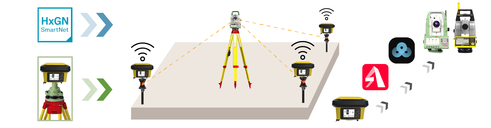
Components of Dynamic Survey Control:
- GNSS positioning with Leica iCG160: This unit offers high accuracy, real-time coordinates, and independence from line-of-sight constraints. It features a built-in screen for easy configuration and allows for convenient re-installation across building heights. The intelligence in the iCG160 GNSS sensor can simultaneously read the correction service, compute a fixed GNSS solution, and output a final computed position as an NMEA GGA string.
- GeoMoS iControl subscription: Provides subscription-based services for comprehensive coordinate computation of survey control points, enabling instant result sharing over file output to GeoCloud Drive or via e-mail.
Leica Geosystems’ Dynamic Survey Control Solution for High-Rise Building Construction
- Base Station/HxGN SmartNet: Provides a stable reference for GNSS data, ensuring high accuracy and reliability in real-time positioning without requiring line-of-sight visibility.
- GeoCloud Drive: Facilitates seamless cloud-based data sharing, ensuring instant access to survey control information as construction progresses. By this, Leica Captivate and iCON field solutions can immediately access up-to-date coordinates from GeoCloud Drive, right on the highest floor level.
- Total Stations for stakeout and validation: Adding 360° prisms below the computed GNSS control points enables total stations to establish resections at the building’s top deck. Additionally, total stations offer independent verification of GNSS data, ensuring accuracy in positioning structural elements.
Benefits:

Benefits of Dynamic Survey Control
Dynamic Survey Control minimizes structural voids and reduces the need for vertical openings, speeding up computations to provide results in as little as 30 minutes with an accuracy of up to ±5mm. It ensures the highest accuracy through continual checking and validation, providing live, on-demand data for compression loads and XY positioning. With efficient staff operations, elimination of cumbersome logistics, and 24/7 real-time data logging, DSC enhances construction accuracy and safety for super-tall buildings.
DSC Application in Other Industries
Dynamic Survey Control extends its transformative capabilities to other large-scale projects. Beyond building construction, DSC’s ability to address blocked or dynamic line-of-sight issues and facilitate precise control in challenging environments makes it ideal for industries such as chip and battery plants, expansive data centers, highways and roadworks, and large property developments. These sectors often encounter similar challenges, including obstructed or damaged control points that necessitate frequent re-establishment of survey references. DSC’s integration of GNSS, TPS sensors, cloud services, and automated workflows ensures reliable, real-time data, improving safety, accuracy, and efficiency across large-scale projects.

Dynamic Survey Control in Veracious Industries
Contact our experts today to learn more about Dynamic Survey Control — our innovative solution designed to ensure precision and efficiency in your vertical construction project. We’re here to help!