


Improved scanning technology offers many options for geospatial professionals who are contemplating purchasing an airborne LiDAR system, ranging from high powered lasers on planes to lightweight sensors on unmanned aerial vehicles (UAV). The detection method selected — single photon or linear-mode — impacts the laser power needed, the flying speed and height of the aircraft and the accuracy of the resulting data. Multispectral LiDAR sensors are also starting to enter the market to address land cover/land use applications and shallow-water bathymetry. To assess the pros and cons of differing LiDAR mapping approaches, consider the following:
- Terrain
Terrain is important when selecting an effective LiDAR system. Do your projects typically include forest, mountains, flat fields, or coastal areas? If you are collecting data to create topographic maps over vegetated or forested areas, LiDAR is the answer. On the other hand, if you are delivering digital elevation models (DEM) over flat bare fields, an imaging system combined with dense matching software could produce the necessary results. One of LiDAR’s most valuable capabilities is penetrating foliage, which cannot be accomplished with an imaging system because of the challenges in getting a clear view of the same point on the forest floor from multiple airborne positions.
The terrain also impacts flying height. In a mountainous area, for example, if you need to fly at 2,000-metre elevations to avoid a crash, a higher powered system installed on an aircraft is required. In a smaller area without obstacles, a UAV carrying a compact LiDAR can fly at a much lower elevation and achieve the desired accuracy. - Data quality level
The system you purchase must be able to meet the specifications of your customer. United States Geological Survey (USGS) mapping standards define LiDAR quality levels by accuracy, point density and precision (repeatability of a measurement). Other countries are adapting these specs to suit local needs. The two most common levels, Q2 and Q1, require accuracy of 10 centimetres, precision of 6 cm and point density of 2 and 8 points per square metre, respectively. Q0 requires accuracy of better than 5 cm, precision of 3 cm and point density of 8 ppsm.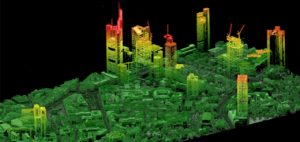
Different technologies deliver varying results. As an example, Leica Geosystems’ linear-mode LiDAR sensor TerrainMapper produces USGS Q0 data while flying at up to 2 km altitude, while the single photon LiDAR system SPL100 meets the requirements for Q1 and Q2, albeit while flying at higher altitude over larger areas with higher coverage rates. - Area of project
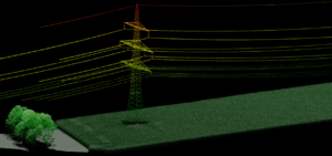
For collection of small areas (site surveys up to a few square km), a compact UAV-mounted system may be the way to go, representing the least expensive system to field for this job type. Linear-mode LiDAR sensors on UAV platforms are quite effective for applications like stockpile volume analysis, infrastructure inspections and utility line monitoring, which require frequent, but localised, revisits.
In general, state and regional mapping is more efficiently conducted with an aircraft rather than a drone. More area can be collected in a shorter period at a higher flight height, while still meeting the point density requirements. Covering more area per hour is important in jobs where total cost is dominated by the amount of time spent in the air. For projects ranging from 10 to tens of thousands of square kilometres, linear-mode sensors are appropriate.
For the very largest-area projects (country or continental scale, generally exceeding 30,000 sq km) with deliverables of Q1 data, single photon technology is more efficient. The Leica SPL100 single photon sensor can collect up to 6 million points per second, which results in a low cost per data point over such large areas. - Radiometric fidelity
To analyse imagery, a colour-infrared band is typically used by automated classification algorithms to discern variations in land cover and land use. With LiDAR point clouds, the intensity data can be used for this type of analysis. The radiometric fidelity of the intensity data is impacted by the strength of the laser pulses reflected to the sensor, and the ability of the detection system to discern various intensity values that might be similar.
If automated classification is being employed and high radiometric fidelity is required to ensure accurate classification, linear-mode is a better choice than single photon because it produces more consistent intensity data with a wider dynamic range. - Scan methodology
Point patterns on the ground can have different spacing in both the along-track (flight) direction and cross-track direction depending on the pulse rate, field of view (FOV), scan rate, flight height and flight speed employed. When extracting features, automated classification algorithms perform better if point spacing relative to one another and density stay consistent, with a good balance between along-track and cross-track spacing.
For a small, flat construction site, a UAV with a compact linear-mode LiDAR can collect the necessary data. However, for larger area mapping with uneven terrain, a manned linear-mode airborne platform operated from a higher elevation will collect data more efficiently. Leica Geosystems has opted to use a Risley prism scanner that generates a conical scan pattern, this scanning technique enhances the point density on vertical surfaces. This design allows a user to employ any FOV with no reductions of maximum scan rate. The pulse rate stays the same with wide or narrow swaths, so the along-track spacing can be maintained, regardless of FOV selected.
Several additional considerations could also impact your purchase decision. For instance, you might find it valuable to have red-green-blue (RGB) or colour-infrared (CIR) ortho-images collected simultaneously with your LiDAR point cloud. Several LiDAR sensors on the market, such as Leica’s SPL100, are equipped with a camera, and offer both RGB and RGB/CIR options. To protect these additional cameras from the elements, a fully integrated camera system is highly desirable, such as the one offered with Leica TerrainMapper. This integration also provides the benefit of simultaneous processing of camera and LiDAR data, as done in the Leica HxMap workflow.
Expandability is another important factor, particularly for new entrants in the market. If you purchase a basic LiDAR system today, can it be expanded to meet your company’s needs as the firm grows? Firms with significant growth plans do not want to simply toss out their lower-performing sensors when they want to expand their range of mapping services. Systems like Leica TerrainMapper can be upgraded from basic LiDAR systems to LiDAR + Imaging to full oblique imaging systems, preserving invested capital along the way. The modular design of a LiDAR system can pay dividends by allowing various components to be upgraded as new technologies become available. For example, CityMapper and TerrainMapper systems can have the imaging sensors upgraded from the current RCD30 systems to the new MFC150, while preserving the Lidar, georeferencing and mission management subsystems
With so many great options on the market, deciding which airborne LiDAR platform to purchase can be daunting. Feel free to contact me at ron.roth@hexagon.com with any questions.

Ron Roth
Product Mgr, Airborne Topographic LiDAR
Leica Geosystems AG