


Continuously changing environments and an increasing population brings the need to construct more buildings and renovate existing ones. This is visible as we look around while we commute, mainly through cities and suburbs.
 Infrastructure, especially relating to buried utilities, must also move with the development pace, continually being maintained, repaired, or extended to catch up with the increasing rate of new construction and renovation of buildings and the expansion of city limits. These tasks’ main challenge is not knowing the accurate position of existing utilities due to poorly maintained, non-existing, or simply just inaccurate maps.
One way to relieve the problems of that challenge is to use the available technologies for underground detection and mapping of buried infrastructure. The accuracy levels required for detecting this infrastructure are critical. If the utility’s location is wrongly detected, or if the utility cannot be detected, this can lead to hazardous situations such as accidents and damages. To protect people and assets, the quality of the detection for infrastructure and the consequent positional mapping must be ensured – this can be achieved by using robust workflow procedures and the right technology and equipment for the task.
Globally there are no enforced standards for utility detection or mapping. Individual countries, however, have adopted methodology and recognised guideline solutions for the mapping of buried utilities. The key players being;
- USA – ASCE 38-02
- UK – PAS 128:2014 (Also adopted by Hong Kong, El Salvador and other Middle Eastern countries)
- Malaysia Standard Guideline for Underground Utility Mapping
- CSA Standards S250 (CANADA)
- Standards Australia Committee AS 5488-2013
- Ecuadorian Institute for Standardization NTE INEN 2873
These standards are robust workflows and work very well, they all differ slightly from region to region, but all follow the same basic principles.
A simple yet common sense approach to utility detection and mapping can be adopted for emerging regions or countries where legislation is still to be realised.
Before legislation was defined, documented, and implemented, The Survey Association (TSA) set out such an approach in the United Kingdom. The process was simple, a boots and braces approach from planning to delivery and the foundation blocks of more stringent legislation that followed. Six levels of quality for utility detection workflow were defined. These levels gave reference to surveyors and project owners regarding types of survey, their relevance provided at each level and the hierarchical approach to achieve a standard of survey. Each level requires tools to perform utility location tasks. Based on the type of tool, the quality of the detection increases as the level increases; the higher the number, the higher the survey’s quality.
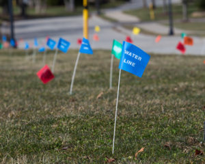
Level 1 – A desktop search of utility company records.
The desktop survey should be the starting point for any project. Some records can be procured for free, but in general, a third party company, at a relatively low cost, can collate and supply the necessary documents in a report document. It should be noted that existing record information is not mandatory in some countries and cannot always be gathered.
There are different service levels for this type of service. Each level will ultimately be determined by price and the number of owners they contact. However, these reports’ limiting factor is that they only show known utilities and typically are a representation only, without accurate location or coordinates. As these records are updated, human nature takes over, and the need to show current live services on a clear and easily understood map takes priority against historical relevance of abandoned service positions that remain in the ground. This may be detrimental to the locating company as they will find unknown detections that could have been classified as an abandoned but identified service.
Level 2 – Performing an Electromagnetic Locator (EML) search in active and passive modes.
EML devices, also called cable locators, can detect conductive metallic services such as power and communications cables or metal pipes. Using Leica DD or Leica Ultra Locator systems, users can simplify the detection process of buried utilities, whether a minimal detection task for small excavation or more complicated route tracing of power, communication cables and metal pipes. Level 2 surveying is ideal for avoidance applications where the services will not be mapped and marked on the ground. The limitations of this type of survey are as follows;
- Using only EML devices, it is impossible to detect non-conductive lines such as concrete, clay and plastic pipes or fibre optic cables.
- Not lifting covers limits the use of active signal application to some services.
- To understand more about Passive and Active mode of EMLs, please read our blog post How cable locators work – Principles of buried utility detection
Level 3 – A Level 2 survey with results plotted onto digital base map in CAD software.
For Level 3, the user can either mark the detected utilities positions on the ground surface and collect the points later with a positioning device such as a Leica total station or Leica GNSS antenna, or you can connect your Leica DD SMART Cable Locator or Leica Ultra with a Zeno GIS Collector and collect data points from detected cables and pipes using Zeno Mobile Mapping software. Digitally mapping the position and depth of buried utilities makes renovation more efficient and saves construction costs.
Level 4 – A Level 3 survey with lifting of manhole and inspection pit covers. Results are digitally recorded and output produced in CAD.
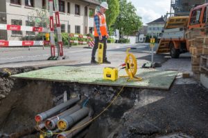
A more comprehensive survey level involves opening manhole covers, inspection chambers and cable access points. More tasks to perform with this level help identify characteristics of utilities such as type, dimension, and material and facilitate the application of more direct signal application through accessories such as signal clamps, connection leads, and sewer sondes. With the range of Leica sondes and conductive threading lines, you can trace drainage and sewer lines after opening the manhole covers and inserting the relevant accessory along the line. Results can be quickly recorded digitally by using Zeno Mobile Mapping.
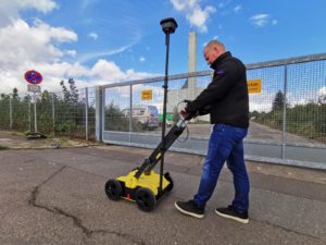
Level 5 – A Level 4 but with a predefined percentage of the survey area covered with close-centred recorded radar scans. This radar data is post-processed and interpreted at a later stage for incorporation into digital mapping along with the Level 4 data.
The main advantage of using Ground Penetrating Radar (GPR) for utility detection is detecting non-conductive materials. With Leica DS2000 Utility Detection Radar, you can detect, position and map utilities on site. Combining Electromagnetic Locating positions marked on the ground, GPR results can instantly be given functionality through live target assigning. Metallic conductive targets can be marked in the data, leaving any non-metallic targets more easily identifiable as they won’t be highlighted. As this level uses a selective approach to GPR data and its collection, the Leica DSX Utility Detection Solution could be deployed. The Leica DSX maximises productivity with cutting-edge software that automates data analysis and creates a 3D utility map in the field without needing to post-process that data collected with the GPR back at base.
Level 6 – A combined survey level of all previous levels but with 100 percent coverage of the survey area and close-centred recorded radar scans.
In addition to the Level 5 specification, this level requires the user to perform 100 percent coverage of the area with GPR scans. This is the highest level of survey and, as such, has the highest perceived quality. Leica Geosystems brings efficiency in workflow and has a solution for every level of survey, culminating with a Level 6 survey and complete system solution.
The recommended approach is to not pick one technique over the other but to use both EML and GPR to complement each other. As both methods will give different results, there will be commonality with the two sets; combining the two gives the best overall results.
Whether you are working in a region under current legislative control or whether performing location tasks in a robust manner as listed above, then the Leica Detection Range of products and solutions will complement your commercial portfolio.
To learn more about detection solutions, go to Leica Geosystems.
For more information regarding EML training, GPR training, or combining the two for utility surveyor training, Leica Geosystems offers Detection Campus for all your training needs. Spend several days with detection experts learning about best practices of performing utility detection and mapping… When it has to be right.
Steve Davies
Global Trainer – Detection Products
Leica Geosystems part of Hexagon