


Speed, height and trajectory.
These are the three elements Dan Sharp, senior imaging officer for West Yorkshire Police in Wakefield, and his team processes, analyses and visualises to provide court-ready deliverables, helping to solve different crimes in the United Kingdom.
Sharp’s team reconstructs crime scenes that can be revisited from user-defined advantage points and obtains actionable data using reality capture technology that generates point clouds for 3D and 2D modelling.
The senior imaging officer also combines video evidence (Closed Circuit TV or CCTV) with point clouds to determine positions, distances heights and other key measurements. Over the past eight years, three methods have been used by West Yorkshire’s crime surveying team, helping to convict aggressors for crimes, including murder, armed robbery and death by dangerous driving:
- Suspect height analysis
- Speed analysis
- Bullet trajectory analysis
When an incident occurs, forensic teams can capture and document every detail of a crime scene with a Leica Geosystems 3D laser scanner within minutes, helping to clear scenes faster. With a 3D environment that can be explored, anyone can analyse from different viewpoints, fly-though, zoom-in, measure, overlay trajectories and annotate imagery on every scene. The 3D models deliver impactful court-ready evidence in various formats, such as sketches, animations, TruViews, reports, trajectory paths reconstruction and analysis.
Suspect height analysis
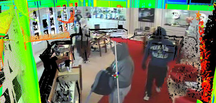
New reverse projection techniques equip investigators with the ability to place the video evidence directly on the 3D point cloud, enabling them to get accurate measurements and show new perspectives.
Three suspects were caught on camera in a series of five armed robberies in the UK. The suspects caught on camera with covered faces left no trace behind. By stitching 3D laser scans and CCTV footage together, Sharp’s team accurately assessed the suspects’ height and discovered the same three individuals were involved in the same five robberies. Sharp’s evidence led to the suspects being measured in custody and matched to the heights calculated, which were given as compelling evidence in court.
Speed analysis
Using speed analysis, Sharp could calculate the speed of a suspect who claimed he had been accidentally walking behind to a man who had been killed. The senior imaging officer laser scanned the area to recreate the scene and the speed of the victim and the suspects. Using crime reconstruction tools in the mapping suite point cloud software and CCTV footage, Sharp proved the suspects took a sprint to deliberately attack the victim.
Using the same technique, which can be used to determine vehicle speed prior to a crash, Sharp’s team provided solid evidence to convict a speeding driver who killed a man and denied speeding.
Bullet trajectory analysis
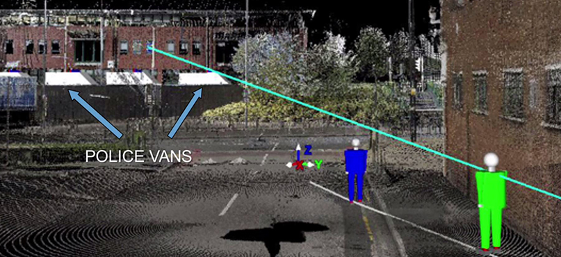
When bullet trajectory rods are placed and scanned, experts can compare the trajectory analysis to the actual position of the firearm at the time of the discharge. Trajectory analysis can also be validated with video overlays.
In the aftermath of a riot in Birmingham, Sharp’s team laser scanned the scene where shots were fired. Suspects claimed they were shooting at the air. The evidence from the crime surveying team proved the opposite. The police vans were stitched into the scene and the trajectory of the bullet was traced, proving the shot missed the head of an officer by less than one metre.
Read full Dan Sharp’s story at PoliceOne, “How a UK agency is combining 3D laser scanning with CCTV tech to solve cases.”
Just like Sharp’s team, officers, detectives and forensic investigators can obtain actionable data and deliver 3D visualisation from captured scan data for a variety of public safety applications. Some of the deliverables powered by reality capture technology are crime scene reconstruction, trajectory and blood spatter analysis, crash simulation, crime and crash scene drawing and event pre-planning.
So, how can you leverage reality capture technology to understand threats and risks in digital reality and provide court-ready evidence through automated verification tools?
Simple to use 3D laser scanning technology, such as the Leica RTC360 reality capture solution, enables fast, accurate and precise laser scanning, allowing crime and crash scene investigators to capture the complete environment around a scene quickly. To support the processing and use of reality capture data in the production of court-ready deliverables, Leica Geosystems has developed Leica Geosystems Incident Mapping Suite (IMS) and Leica Map360.
Leica Map360 is a desktop software solution that lets users import, process, analyse, visualise and create court-ready deliverables. Map360 allows importing evidence measurements from multiple sensors, including support for total stations, laser scanning, GNSS, MultiStations, UAVs and Pegasus mobile scanning solutions while providing a common user experience.
Users can access valuable scene reconstruction tools and work on ready-to-use templates to create diagrams for exhibits. Map360 allows to quickly and easily draw 2D and 3D lines, such as roadway lines, tire marks, guard rails, fences, utilities and more. Sophisticated crash and crime scene reconstruction and analysis tools are included for a variety of reconstruction calculations, including speed, deacceleration factor, kinetic energy, momentum, kinematics and more.
Below are some of the Map360 features and extensions you can leverage to produce court-ready deliverables like Sharp and his team.
Witness Viewpoint analysis
Corroborate or disprove witness statements about what they could or could not see during the incident. Pick a point, add a viewpoint at a specific height and take a look in vivid 3D. There is an option to define the witness viewpoint and switch from different witness viewpoints from any angle. Users can name the view, pick the location and set the height of the witness. Views can be turned into drawings and be exported.
Animation extension
Create dynamic animated views from different standpoints and witness’ views and switch between camera setups based on key events defined in the animation.
Bullet path reconstruction
Accurately determine bullet trajectory from measured or scanned trajectory rods. If users scanned the rod, Map360 computes the best fit trajectory with the points defined by the user. If another method, like a total station, was used to capture the start and endpoints for a rod, users can draw a trajectory cone.
Learn more about Leica Geosystems Incident Mapping Suite: https://leica-geosystems.com/products/laser-scanners/software/ims
Check out the training opportunities at Leica Geosystems IMS school: https://leica-geosystems.com/products/laser-scanners/software/ims/training
Visit Leica Geosystems’ Public Safety Groups: https://psg.leica-geosystems.us/
https://leica-geosystems.com/industries/public-safety/leica-geosystems-public-safety/laser-scanning-for-forensics-and-public-safet

By Renata Barradas, Communications Manager at Hexagon Geosystems