


Combining measurements and imagery, 3D laser scanners can capture any site, for example plants, buildings or crime scenes, to create a 3D digital model. The resulting 3D data can be used for design and comparison purposes, to ensure site safety in inhospitable environments or as evidence in a criminal case, capturing every detail with to-the-millimetre accuracy. In this blog, we discuss how recent laser scanning technology combines one-touch operation with portability and speed to deliver high levels of accuracy, automation and the ability to create 3D environments in a matter of minutes.
Laser scanning and 3D reality capture
Laser scanning is an integral part of the overall reality capture portfolio. Since Leica Geosystems brought laser scanners to the market more than 15 years ago, the technology spearheaded the 3D documentation and surveying experience for many customers. Laser scanning technology is now very well accustomed to the workflows of many customers, and it is considered as one of the most essential components in the 3D reality capture basket. “Other key technologies that our customers deploy range from mobile mapping systems mounted on a vehicle or moving platforms, airborne systems, and, of course, the Leica BLK360, which has further revolutionised the experience of deploying laser scanning technology for 3D reality capture purposes. From a software perspective, our in-field and office solutions extend into the same experience,” says Faheem Khan, Vice President Survey Solutions at Leica Geosystems.
Democratising reality capture
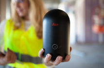
Hexagon has taken a leading role in democratising reality capture technology and make it available for the masses in two ways – the collection phase of a project and the consumption phase of a project. From a collection perspective, the introduction of the BLK360 in 2016 set a benchmark in the industry in terms of size, weight and ease-of-use. With a one push-button solution that weighs less than 1 kg, portability and ease-of-use made this technology massively available to data producers who wouldn’t normally consider using such technology. Software solution workflows have been extended to connect multiple industries and multiple domain experts, leveraging 3D reality information to address business needs. “If you are an architect, you can very quickly take a 3-dimensional document of your facility and carry out a design. If you are a police officer, you can very quickly preserve the crime scene and carry out an investigation. If you are a surveyor, you can very easily, at the push of one button, compute volumetric information that would have taken hours in the past,” explains Khan.
Digitalising workflows
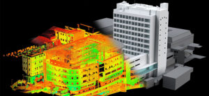
Leica Geosystems’ reality capture solutions create digital twins of reality. “We collect a digital 3D point cloud and present the as-built situation of the captured scene. In this digital representation of reality, any measurements or computations can be made. This includes distance measurements, volume calculations, clash detection, and more. In the past, many of these tasks required a lot of analogue measurements, like tape measurements, and yet not all are possible with such analogue methods,” describes Hans Tuexsen, Business Director Terrestrial Laser Scanning at Leica Geosystems.
Opening opportunities for new industries and professionals
With the latest introductions to our reality capture portfolio, we open the door to many other professionals from many other industries. The main driving factor for the broad adoption of Leica Geosystems solutions are ease-of-use, productivity and portability of the equipment. Automated workflows in the field and in the office make our technology attractive for everybody interested in capturing and visualising 3D data.
Improving efficiency and productivity
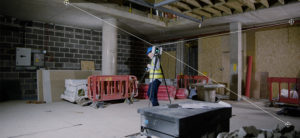
Efficiency and productivity are the main goals when designing and developing the latest generation reality capture products. The Leica RTC360 is the fastest 3D laser scanner in the market today. With a scan speed of 2 million points per second and its unique spherical camera system, the RTC360 captures a complete 3D scan and panoramic High-Dynamic Range (HDR) imagery in less than two minutes. However, there’s other unique and efficient technology contained in this product. “The Visual Inertial System (VIS Technology) automatically tracks the scanner movement from station to station when you are on site, leading to an automatic pre-registration directly in the field and on a mobile device. Leaving the field to final registration and reporting in the office, only a click away. In the office, it’s as easy as drag, drop, done,” explains Tuexsen.
Technology benefits for customers
Apply Capnor, a company in Norway working in the onshore and offshore plant industry, uses reality capture technology as part of their day-to-day business. Especially in the offshore environment, speed, data quality and safety of the workers are non-negotiable. No disturbances of the daily operation or expensive shutdowns are accepted in this environment, and a minimum of time spent on site equals to a minimum of safety issues. Apply Capnor invested into several RTC360 3D laser scanner systems as speed and reliability were key when deciding on the equipment needed on site.
Another example is Enel, an electricity company in Italy, who invested in a whole fleet of Leica Geosystems reality capture products. For the company, speed and simplicity, as well as fast and reliable data capturing to document its facilities, were the main reasons to invest in our products. This means scanning hundreds or even thousands of electrical cabinets in a single facility. Also, high quality of imaging for 3D documentation was another strong argument for the RTC360.
Leveraging other state-of-the-art technologies
There are many ways to leverage technologies that we hear about every day. “We hear about artificial intelligence (AI) all the time. We hear about how AI is shaping lives, but it is also making significant impacts in reality capture workflows,” says Khan. “Investments made in AI machine learning is starting to pay dividends. Customers can turn to Leica Pegasus:Manager, a software product that processes mobile mapping data, to run the routine of classifying the dataset automatically and be able to extract features with less inaccuracies and with higher speed. Those are some of the benefits and dividends AI produced for us.”
We see customers leveraging Virtual Reality (VR) and Augmented Reality (AR) technologies to conduct site training and create virtual site visits. This is also starting to provide some mainstream value to public safety agencies. Cloud technology has been a major enabler for several workflows. Leica Geosystems offers Leica TruView Cloud, which allows customers to collect data from the field and consume this in downstream applications in minutes.
Reality-capture data tends to be very rich in information (and size), solutions like TruView simplifies this richness into a lightweight representation of reality. Leveraging this lightweight cloud technology and edge computing allows us to connect with multiple downstream applications. One example is the connection with Hexagon PPM’s SDx product, which allows owner operators running their facilities to be safer, more efficient in really executing their work processes.
The future of reality capture
Reality capture is only getting better. There has been a big performance leap in the industry in the last three years. A project that would have taken a week to complete now finishes in a day. “Hexagon will continue to drive this productivity gain so customers benefit. From collection to getting final actionable data, you can use reality capture to visualise actionable data to make better-informed decisions. For example, if you are running a building construction project and you want to make sure a slab is fabricated correctly, you can turn to reality capture for quality information, even on site. Speed, automation, simplicity of workflow and end-to-end productivity drives this. Making reality capture as simple as using a smartphone is one of the goals. Judging from the recent deployment of technology, it’s heading in the right direction,” explains Khan.
To listen to the podcast, click here: https://hxgnspotlight.com/3d-environments-matter-minutes-outlook-recent-reality-capture-technology/
Michelle Byrne
Senior Marketing Communications Manager, Terrestrial Laser Scanning
Global Product Marketing Communications, Reality Capture Division