


Working smart and efficiently is a vital aspect and expectation of an organisation, frequently projects require inputs from many disciplines spread across multiple sites which present many challenges and frustrations. Centralising data brings many benefits especially if it is easily accessed via a hosted system. Once you have a centralised system, reporting becomes an automated process reducing the workforce burden, potential errors and costs associated with tasking an employee or organisation with the job. With the correct system in place you get the information you need when you need it in a timely and cost-effective manner.
A connected world
A trend to centralise data, maximise I.T infrastructure and use the latest connected technology is often seen as essential in achieving improvements on site.
Embracing technology is common especially in consumer markets where there are apps to control everyday use items, such as heating systems, lightbulbs, speakers, voice-activated search engines etc.
In the workplace, connected technology is similarly being embraced and information from multiples sites and disciplines can be transmitted directly from the site to a central hosted system providing organisations with accessible data in near real time. The value behind this is immeasurable and when the right formula is found it delivers significant improvements in key performance measures including workforce efficiency, quality and safety.
Let’s take a couple of examples on how connectivity can improve utility detection.
Our utility software suite DX Shield and DX Mapping for utility detection solutions allows organisations to centralise site information.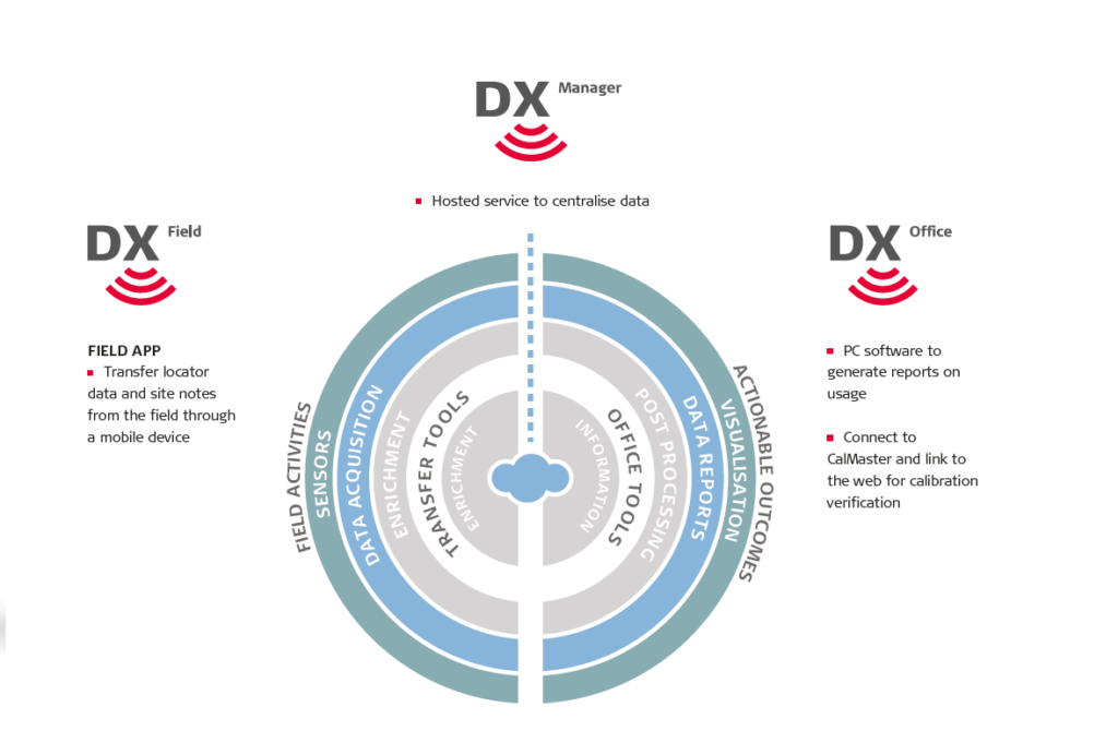
With DX Manager Mapping, surveyors can turn up on site log into the software and see every form or task they need. Ground surveys can be conducted by connecting hardware and software and this can be transmitted in real-time from the site to the office for post-processing. This means that utility maps can be updated before the surveyor has left the site or additional survey information can be requested by their colleagues in the office, increasing speed and efficiency on many levels.
The project can also be updated and added to the hosted DX Manager Mapping over time, meaning that your utility maps are always up-to-date, available centrally and, when using Leica Geosystems equipment – accurate.
With DX Shield software, groundworkers can positively contribute to a reduction in utility damage and help organisations to develop or improve safe systems of work, protecting workers and utilities from harm. Connecting hardware and software provides an automated upload process for locator scan information and site notes, such as risk assessments and photos detailing where, when, and how the excavation process or site work has been carried out. The uploaded data is saved to the hosted DX Manager Shield where team leaders and managers can login and analyse performance in near real time or over longer periods to make process improvements or to identify training needs. The data can be retrieved and reviewed for future work or client requests.
Using DX Software utility work becomes streamlined, data is centralised and can be recalled with ease. Digitalising the workflow process means organisations can significantly reduce costs and expenditure whilst driving improvements in key performance measures especially when projects are complex and widespread. Centralised information becomes available and can be easily retrieved for future use helping organisations to work safer, smarter and simpler.
For more information on utility detection solutions visit: leica-geosystems.com/products/detection-systems