


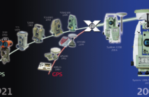
While the origins of our company date back an impressive 200 years to the founding of Kern & Co. in 1819, today, we embark on a journey to explore the key surveying innovations that have shaped the last 30 years of Leica Geosystems.
At Leica Geosystems, surveying is not just a profession; it’s ingrained in our DNA. Since the beginning, we have been at the forefront of groundbreaking innovations, transforming the surveying landscape and reshaping how professionals interact with their environments. Watch the video to learn how we have grown by becoming the world’s first in surveying innovation.
When focussing on the previous three decades, with the introduction of handheld laser distance meters in the ’90s to the democratisation of laser scanning technology in the 2010s, surveyors have witnessed a continuous evolution that has reshaped their profession. As we reflect on the key evolutions in the geospatial sector, it becomes evident that the future holds even more exciting opportunities and challenges for surveyors.
Let’s take a walk down memory lane to appreciate the key milestones that have defined our journey.
The ’90s: Pioneering Handheld Laser Distance Measurement
The decade of the ’90s marked a pivotal period of change and innovation. In 1993, we unveiled the Leica DISTO, the world’s first handheld laser distance meter exhibited in Paris. This device revolutionised precision measurement, setting the stage for a new era in surveying technology. In 1995, the GPS system 300 was introduced, enabling high-precision navigation with real-time surveying—a game-changer that allowed precise coordinates to be received while still in the field. By 1998, the introduction of total stations TPS300 and TPS 1100 introduced reflectorless measurement, streamlining measurement processes. In the year 2000, a groundbreaking moment unfolded with the debut of the ADS40, the world’s inaugural digital aerial sensor. This revolutionary technology fully digitized aerial images, marking a pivotal advancement in the field of photogrammetry.
-
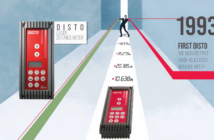
- The first Leica DISTO, the world‘s first hand-held laser distance meter (exhibited in 1993 in Paris).
-
- In 1995, the GPS System 300 introduced high-precision navigation and real-time surveying, providing accurate coordinates directly in the field.
-
- In 1998, the introduction of total stations TPS300 and TPS 1100 enabled reflectorless measurements for the first time.
-
- In 2000, the ADS40, the world’s first digital aerial sensor, digitally transformed aerial images, revolutionizing photogrammetry.
The 2000s: Convergence of Technologies
As we entered the new millennium, the 2000s witnessed the convergence of technologies under the umbrella of System 1200. In 2004, satellite geodesy and tachymetry were successfully combined, providing surveyors with a unified platform for enhanced efficiency. The GPS1200+, introduced in 2008, demonstrated our commitment to staying ahead, capable of receiving all available and future-planned GNSS signals. The Leica ScanStation C10, introduced in 2009, pushed the boundaries of laser scanning technology, allowing for the acquisition of up to 50,000 points per second with unparalleled accuracy.
-
- In 2004, Satellite geodesy and tachymetry were successfully combined in a unified platform called System 1200.
-

- In 2008, the GPS1200+ could receive all current and future GNSS signals.
-
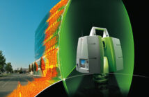
- In 2009, the Leica ScanStation C10 enabled capturing 50,000 points per second up to 300 meters away with millimeter-level accuracy.
The 2010s: Accelerating into New Frontiers
The last decade not only strengthened but accelerated the geospatial sector into new markets. In 2012, the launch of the Leica ScanStation P20 broke barriers, achieving previously unattainable scanning speeds of up to one million points per second. The Leica BLK360, introduced in 2016, democratised laser scanning technology, paving the way for a family of disruptive BLK products, including the BLK2GO, BLK247, BLK2FLY and BLK ARC. These innovations showcased our commitment to making surveying more accessible, versatile and autonomous.
The fusion of laser scanning with technologies like edge computing resulted in transformative solutions such as the Leica RTC360, redefining reality capture. Fusing sensors led to groundbreaking innovations like Leica CityMapper, combining newly developed cameras and laser sensors. The Leica GS18 T GNSS RTK rover, eliminating the need to hold the pole vertically, and the Leica GS18 I GNSS RTK, adding visual positioning technology, revolutionised how surveying professionals measure with unparalleled safety, ease and accuracy, even in challenging terrains.
-
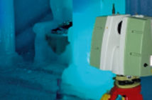
- In 2012, the ScanStation P20 introduced unprecedented scanning speeds, reaching up to one million points per second, while maintaining excellent precision over distances up to 120 meters.
-

- In 2016, the Leica BLK360 was introduced, making laser scanning technology more accessible to the public.
-
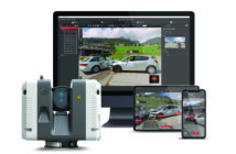
- Laser scanning, combined with modern technologies such as edge computing, has given rise to innovative reality capture solutions like the Leica RTC360.
-
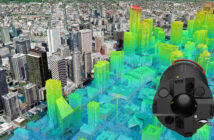
- City Mapper exemplifies geospatial innovation by combining advanced cameras and laser sensors.
-
- The GS18 T GNSS RTK rover, enabling non-vertical pole use, and the GS18 I GNSS RTK with visual positioning tech, have revolutionized surveying techniques.
Predictions for the Future
Looking ahead, the surveying profession is poised to face new challenges and opportunities. As an applied science, geomatics is encountering ongoing innovation challenges due to rapidly changing technologies such as LiDAR, cloud computing, IoT, and AI. IT expertise is becoming increasingly important, and surveyors will need to adapt to these changes continually. Yet, the future appears ripe with opportunities for surveyors who embrace diversification and innovative technologies, positioning themselves at the forefront of geospatial evolution.
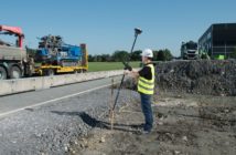
To succeed, surveyors must diversify their offerings, exploring areas like 3D laser scanning, deformation monitoring, mobile mapping, and underground utility detection. Adopting new positioning and measuring technology is crucial for surveyors to thrive. Safety remains paramount, with technologies like ground-penetrating radar and UAVs aiding in hazard-free surveying. Finally, surveyors are best positioned to play a pivotal role in establishing smart cities by seamlessly integrating diverse datasets.
Surveying: A Journey of Evolution with Leica Geosystems
The surveying profession has witnessed a remarkable journey over the past 30 years, embracing digital transformation and continuously evolving with technological advancements.
As we step into the future, it’s clear that surveying is not just a profession for us—it’s a journey of evolution. From pioneering handheld laser distance measurement to democratising laser scanning technology and embracing transformative solutions, Leica Geosystems remains committed to shaping the future of surveying. Surveying is not just in our history; it’s in our DNA, and we’re excited to continue this journey of innovation, collaboration, and excellence in the years to come with you, our customer.
Explore the essence of surveying in our DNA by clicking here to learn more.