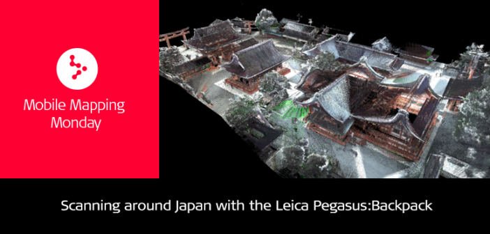
Point Cloud of Fushimi Inari Shrines in Cyclone
I was recently in Japan for two weeks to train a new client who recently acquired the Leica Pegasus:Backpack. During the weekend, I challenged myself to collect data in as many fascinating places as I could – alone. In just one day, I visited mountain trails, shrines, busy pedestrian intersections, and other well-known districts – then just as efficiently, I prepared demos for my colleagues in Japan. How was I able to scan such varied environments in just one day?
Autonomy

Pegasus:Backpack scanning and imaging inside thousands of torii at Fushimi shrine
One of the absolute greatest aspects of the Pegasus:Backpack is its autonomy. There is no planning needed and no need for extra personnel to help in the logistics or processing. In other words, show up when you want and GO!
Speed
Client training was in Osaka, Japan and ended Friday afternoon. After training, I traveled by taxi and then 15 minutes by bullet train to Kyoto, Japan with some luggages and the Pegasus:Backpack. I choose Kyoto because it was the Imperial Capital of Japan for over a thousand years (794 through 1868); hence there are thousands of beautiful, well preserved palaces, Buddhist temples and Shinto shrines to scan. After a brief search on “Kyoto”, I decided on scanning:
- Fushimi Inari Shrine – Shinto shrine famous for its thousands of vermilion Torii Gates
- Arashiyama Bamboo Grove – soaring bamboo forest (sure to cause GNSS outages)
- Yasaka Jinja – one of the most famous shrines in Kyoto founded over 1350 years ago
- Gion District – Kyoto’s most famous Geisha district filled with shops and restaurants
I started my Sunday at sunrise to scan Fushimi first. After a 15 min taxi ride, I was at the base of Inari Mountain which houses Fushimi shrines; the picture below (left) is the trajectory as seen by Google Earth; the picture below (right) is the resulting point cloud from Cyclone.

Surveyed half a mountain in under two hours including elevation differences of over 270 meters

Overall Point Cloud and front Torii Gate of Fushimi Shrine in Cyclone
Overall, I scanned the entire 2.5 km Fushimi Inari trail and shrines in under two hours with an estimated 3D positional accuracy of 0.018m.
Up next was a 20 min taxi ride to Arashiyama Bamboo Grove. This area was a little over 1 km with lots of GNSS loss due to thick bamboo stalks. Accuracy was under 3 cm. The scanning time was longer than needed, 45 min, because I took my time to admire the beauty of the scenery.

Arashiyama Bamboo Grove with some bamboo over 20m tall (GNSS loss)

Pegasus:Backpack scanning and imaging Arashiyama Bamboo Grove
After another 20 min taxi ride, I was in the heart of Kyoto for the Yasaka Jinja and Gion Districts. Total scanning time for both was under an hour for 3.5 km.

Photo of Yasaka Jinja

Point cloud of Yasaka Jinja with colors from internal camera

Greater map of Kyoto showing all the Pegasus:Backpack surveys performed in one afternoon (conventional tripod mounted scanners would have taken several weeks with multiple field personnel)
Transportability

Trajectory of Shibuya Crossing

Transporting Pegasus:Backpack on bullet train
My next meeting was in our Leica Geosystems Tokyo office, scheduled for Monday morning. I took a three-hour bullet train from Kyoto to Tokyo that Sunday afternoon after scanning the four Kyoto sites. Arriving in Tokyo roughly at 4pm, I had a few hours of sun left and decided to scan Shibuya crossing, the busiest intersection in the world! People, traffic, and an urban canyon resulting in GNSS loss was again no problem.
For a video point cloud tour of these sites please click here:
The Leica Pegasus:Backpack is a unique mobile mapping solution created for rapid and regular reality capture. Designed to be completely portable, it fills the gap where traditional mobile scanning systems reach their limits.

Frank Collazo
MED (Mobile 3D) Reality Capture Consultant at Leica Geosystems AG


