


How advancements in spatial data collection are enabling smarter urban planning
Recent developments in reality capture technology are making it easier for more people involved in city planning and urban management to collect data for smart city projects. With simplified hardware and software, simpler workflows and AI algorithms doing the heavy lifting, cities can be more creative in what they can measure and model. Here, we look at three ground-breaking examples of projects using digital twins to solve urban problems of litter and fly-tipping, traffic jams and infrastructure planning.
Why smarter cities matter:
- Attracting talent and skills: Smart cities with good infrastructure and economic conditions attract talent and skills, which in turn attracts business investment. This helps counteract shortages of skilled workers.
- Enhanced security: Smart cities employ digital twins and simulations to model complex urban challenges. This allows errors and problems to be addressed in virtual environments before manifesting in the real world. This enhances security for citizens.
- Sustainability: Digital twins and data analytics support efficient and informed decision-making around sustainability initiatives, like renewable energy generation. Being able to model and optimise plans digitally contributes to the faster adoption of sustainability projects.
Tackling urban environmental pollution
Urban environmental pollution, from fly-tipping of domestic and industrial waste to graffiti defacing public and private property, causes significant harm. Not only is it unpleasant to look at, but it can prevent those with accessibility issues from being able to navigate public spaces. It is an expensive problem for local authorities and municipalities to deal with, from the administration required to report waste or vandalism to the cost of proper disposal.
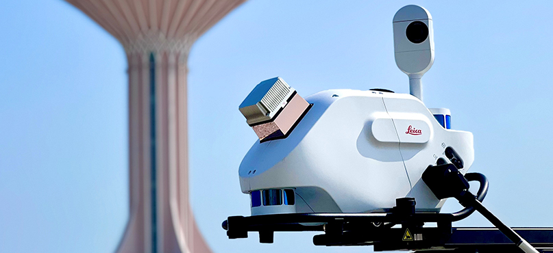
One of our customers has developed an innovative solution to tackle urban environmental pollution more efficiently. They are piloting reality capture technology to identify incidents and automatically assign them to contractors. By visually mapping the city environment, they can detect waste or abandoned cars, broken lamp posts, graffiti, and street damage or outdated street furniture. They capture imagery across the city using mobile mapping, continuously monitoring for anomalies. With lamp posts for example, by using automated point cloud analysis in Leica Cyclone 3DR, the system can identify any posts that are not vertical. This is only possible using a solution like the Leica Pegasus TRK, combining high-resolution cameras, LiDAR scanners, and GNSS receivers to capture precise 3D imagery and point clouds.
By combining this sensor data with geospatial analytics tools, they can pinpoint the location of any incidents for follow-up. The technology provides data to monitor the state of infrastructure continuously. Software solutions then transform this into actionable information on the ground. Automated workflows allow assigning jobs like cleaning or maintenance directly to the responsible departments and contractors.
The project is still in the early phases but shows the immense opportunity of reality capture technology beyond 3D city modelling. Reality capture data moves city management from sporadic surveys to near real-time status updates. And it exemplifies the breadth of applications possible once a digital replica of the urban environment exists.
Population data collection for infrastructure development
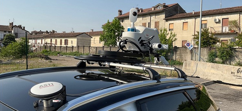
In Italy, one of our customers – a telecommunications company – is mapping city infrastructure to inform its planning. By visually mapping buildings in an area, the company can extract house numbers, mailboxes, and intercom systems to calculate how many homes and businesses are in the area. They are then using this information to plan for broadband expansion. Using mobile mapping, this approach has proved 60% quicker than traditional surveying techniques. Historically, this information would have been gathered from census data, which may have been outdated, and/or by recruiting and training a temporary workforce to map an area. The data they collected would then need to be processed, edited, and tabulated, all work which can be automated using a reality capture solution.
This is an interesting example because the type of data gathered by the telecommunications company through mobile mapping has many further uses. Combined with other GIS data sources, it could provide valuable city-level insights for local government and lay the foundation for all kinds of planning decisions, from broadband to schools to waste management. This process could even replace or bolster traditional data-gathering techniques used in population censuses.
Fewer traffic jams and faster last-mile deliveries
Cities like Munich and Hamburg in Germany are leading the way in using reality capture technology to enable better urban planning decisions. For example, Munich’s city authority has implemented digital twins to simulate optimised traffic flows around construction sites. The results of the simulations are used to create traffic diversion routes that minimise congestion. In Hamburg, reality capture data from mobile mapping is used to optimise last-mile delivery logistics. The authority is using data on existing infrastructure to identify ideal parking locations for unloading zones that minimise distances between trucks and shops. The digital replica of the city allows for testing different planning scenarios to find the most efficient option.
Recent advancements in reality capture technology are breaking down barriers that once put smart city projects out of reach. Simplified solutions combined with the power of spatial analytics make the promise of data-driven planning attainable for cities of all sizes. The expanding applications demonstrate why these capabilities are a critical investment in future competitiveness. Cities that leverage these innovations can start improving the quality of life for citizens immediately. Unlocking the full potential of spatial data to monitor, analyse, and optimise urban infrastructure is critical to not just smart cities but responsive, resilient, and liveable cities.

Christian Schäfer
Business Director Mobile Mapping Systems
Reality Capture division
Click here to learn more about reality capture and mobile mapping systems.