The heavy construction industry is familiar with the challenges of managing complex projects, strict deadlines, and demanding budgets. However, the industry has witnessed a transformative shift in using reality capture technology in recent years. This innovative approach combines hardware and software solutions that are designed to revolutionise various phases of the heavy construction workflow. It allows surveying professionals working in the industry to provide accurate information more quickly, creating better decision-making conditions before, during and after a build. In this blog, we explore the significant impact of reality capture technology throughout five phases of a heavy construction project, from planning to maintenance.
Common across each phase is how reality capture technology can increase profit for surveying companies. It is easier to use and faster to set up than traditional equipment, reducing the hours required on-site. It can also reduce the size of the teams needed to conduct a survey as most reality capture hardware is suitable for one-person operation. The ground covered in the same timeframe is much larger, improving efficiency.
Using reality capture technology means surveyors can capture 3D spatial data from a distance. Most importantly, this has safety benefits in allowing a surveyor to capture a hazardous site from a position of safety. Still, it can also save money in preventing the need to survey outside of site working hours. By bringing these benefits together, reality capture technology can increase the number of projects a surveying professional can take on.
Mobile mapping or terrestrial laser scanning?
There are broadly two types of reality capture hardware: mobile mapping using mobile laser scanners that scan while they move and terrestrial laser scanners that are static, mounted to a tripod. Depending on requirements, both types have uses within the different stages of the heavy construction workflow. Mobile mapping is more efficient for coverage of a large area, but there is a slight payoff in accuracy. For road building projects for example, the speed and convenience of mobile mapping makes it a great solution, with those benefits multiplied over longer distances. A terrestrial scanner is more suitable when you need millimetre accuracy at a shorter range.
In this introductory article we give examples of how different products and solutions can be used in the various phases of heavy construction, however, it is by no means conclusive! In reality, the same solutions can be used for different jobs in every phase and we are always inspired by seeing how our customers use our technology in innovative ways to solve their specific challenges.
 1. Design and capture: Unveiling the current site conditions
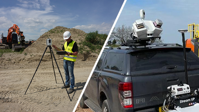
Accurate knowledge of site conditions is essential in heavy construction before any above-ground or in-ground infrastructure can be developed. Pre-construction calculations for planning and logistics need to be determined. Reality capture technology, such as 3D laser scanning or UAV-based photogrammetry, allows construction professionals to capture highly detailed and accurate data of the existing environment.
This data serves as a foundation for project planning, logistics, and pre-construction calculations. By reducing guesswork and accurately representing the site, reality capture technology minimises errors, reduces costly rework, and improves decision-making processes. Reality capture allows professionals to avoid uncertainty about site conditions between all parties working on a construction project. It creates ‘one truth’: a holistic representation of reality, which can be shared with all stakeholders, avoiding inconsistencies between different project plans.
Solutions include:
- The Leica BLK2GO handheld imaging laser scanner is mobile, wireless, and lightweight, designed for fast reality capture on the move, allowing you to capture site conditions quickly and easily.
- For surveying a large area above ground, the Leica BLK2FLY autonomous flying laser scanner creates 3D point clouds while flying.
- The Leica Cyclone FIELD 360 mobile app directly links the 3D data acquisition in the field with the Leica RTC360 laser scanner. This combination allows you to accurately assess site conditions immediately at speed.
- The Leica CloudWorx CAD plugins offer users the unique ability to work with reality capture data directly inside a CAD system of choice. Various tools and smart automation speed up 2D drawing creation and model 3D objects and surfaces. CloudWorx is frequently part of the heavy construction workflow, turning scan data into digital terrain models.
 2. Estimate and plan: Data processing for accurate estimates
Reality capture technology accurately captures site conditions and provides comprehensive data sets that can be processed using specialised software. This data processing enables professionals to generate accurate estimates and forecasts. By leveraging advanced algorithms and modelling techniques, the software can extract essential information from the captured data, such as measurements, material quantities, and spatial relationships. With this valuable insight, construction companies can produce more precise estimates, reducing the risk of budget overruns and improving project planning.
Solutions include:
- After scanning a site with the RTC360, scan data can be imported into Leica Cyclone REGISTER 360 PLUS for further post-processing. Taking advantage of the RTC360’s Visual Inertial System (VIS), Cyclone REGISTER 360 PLUS will automatically place project data on real-world coordinates and complete a registration with minimal manual assistance from the user.
- Then, point clouds can be exported and used in Leica Cyclone 3DR for its many applications. Whether it is volume calculations, checking verticality, auto-extracting ground to create TIN, creating cross-section reports, or checking as-built versus design.
 3. Mobilise and prepare: Streamlining on-site planning
During the mobilisation and preparation phase, surveyors working in heavy construction focus on planning resources, materials, and equipment required for the project. While reality capture technology may not be directly deployed in this phase, the data captured earlier can significantly inform and optimise planning processes. Accurate and up-to-date site information obtained from reality capture technology can assist in identifying potential challenges and enable efficient allocation of resources, thereby enhancing overall project productivity.
Solutions include:
- For projects involving different suppliers and contractors, Leica Cyclone ENTERPRISE is a simplified enterprise-level management and collaboration platform. Powered by Leica Geosystems’ JetStream technology, Cyclone ENTERPRISE is a single source of truth, eliminating redundant and duplicated data sources. It enables a common project view, thereby improving quality and productivity.
 4. Construct and build: Tracking progress and ensuring quality
Reality capture technology is vital in the construct and build phase by facilitating progress tracking, quality assurance, and documentation. With the ability to capture data at different stages of construction, professionals can monitor the project’s progress against the original design. By comparing as-built conditions to the planned design, any discrepancies or potential issues can be identified early, enabling prompt corrective measures. Additionally, the captured data can serve as a visual documentation of the project’s evolution, facilitating effective communication with stakeholders and proof of work for accurate billing, such as monitoring bulk earthworks and calculating daily volumes. It minimises the risks of human error and incomplete data while monitoring any movement next to construction sites and improving quality through visualisation, verification, and validation of work, allowing informed and fast decision-making.
All of this can be achieved with minimal disruption. Some reality capture solutions are ideal for long-range scanning from a distance, meaning that surveying professionals can capture detailed data without disturbing building work or putting surveyors at risk. Other solutions are highly portable, and in the case of the Leica BLK2FLY autonomous flying laser scanner, aerial.
Solutions include:
- The Leica ScanStation P50 is ideal for long-range scanning at a high level of detail. It maximises productivity by scanning inaccessible places at a safe position on site. The Cyclone FIELD 360 app links the 3D data acquisition in the field with the ScanStation P50 laser scanner and final data registration in the office with Cyclone REGISTER 360
- The Leica iCON site applications let you use point cloud data to increase performance and accuracy in all site tasks. For example, if you are working on cut and fill calculations or on pave milling, you can verify as-built data against design models much more quickly than verifying manually, speeding up project progress.
 5. Operate and maintain: Long-term monitoring for sustainability
Once the build phase is complete, reality capture technology benefits the heavy construction industry. By implementing long-term monitoring systems, such as IoT sensors or reality capture scans at periodic intervals, construction companies can ensure the integrity and safety of their structures and create a complete digital record of projects. These systems provide valuable data on structural movement, environmental changes, and asset performance, enabling proactive maintenance and minimising the risk of costly failures. By embracing reality capture technology for long-term monitoring, construction professionals can optimise the lifespan and sustainability of their projects.
Solutions include:
- The Leica Pegasus TRK700 Neo is a mobile mapping solution that captures over a million data points per second. It is robust enough to travel on uneven surfaces while mounted to the roof of a vehicle, making it ideal for monitoring the conditions of roads and runways regularly. Monitoring can be done without closing a road and is much faster than traditional methods of manually taking measurements at five or 10-metre intervals.
- For asset management, Hexagon’s Scan-to-EAM solution combines reality capture data with the identification of assets to import into an EAM solution database. This increases efficiency and reduces costs for facility managers, who will always know the status of every asset.
- Reality Cloud Studio, powered by HxDR, is a powerful cloud application for reality capture data visualisation, collaboration and storage. It allows you to mix and match devices, merge scans and register 3D data automatically. It is the natural step in the evolution of digital transformation on any site.
Reality capture technology has emerged as a game-changer in the heavy construction industry, transforming traditional surveying processes and revolutionising project outcomes. From accurately capturing site conditions to streamlining planning, tracking progress, and enabling long-term monitoring, reality capture technology offers many benefits throughout the various heavy construction phases. By embracing this innovative approach, surveying professionals can enhance efficiency, improve communication, reduce errors, and deliver projects on time and within budget. As reality capture technology continues to evolve, more and more construction companies are realising its potential to reshape and improve their workflows and project outcomes.