


British heritage charity The Dudley Canal and Tunnel Trust (DCTT) is responsible for maintaining and preserving The Dudley Tunnel, the second-longest canal tunnel on the UK’s canal network. More than 200 years old, the tunnel is now a popular tourist attraction, where visitors can explore abandoned mines via the canal network and learn about the lives of the 18th-century canal and mine workers. DCTT – with the support of Historic England – has a goal to use digital twin technology to improve many aspects of its work, from inspections to training to the visitor experience. Here we look at three ways that reality capture supports this transformation with insights relevant to projects across the heritage sector.
 1. Moving from a reactive to a proactive approach to conservation
The DCTT began to explore reality capture as a vital technology that would enable the team to take a more proactive approach to their preservation work. Seeing the whole site in a high level of detail – including difficult to access areas – would make it easier to inspect the tunnel and cave network and identify potential problems before they arose. To do this, Traci Dix-Williams, Chief Executive Officer, Dudley Canal and Tunnel Trust, explains, “we had to review and adapt our current monitoring and inspection approach and bring in new technology.”
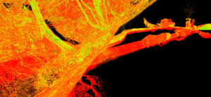
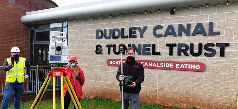
Johnson Poole & Bloomer Ltd (JPB) – an independent multidisciplinary engineering and scientific consultancy company – was contacted by the Trust to provide them with a georeferenced point cloud model of the site, both above and below ground. In collaboration with SCCS, The Survey Equipment Company, point cloud data was captured using Leica Geosystems 3D laser scanning and mobile mapping solutions and then processed for digital modelling.
The various solutions implemented enabled the Dudley Tunnel to be mapped and viewed completely, allowing for reliable data analysis and dissemination for monitoring and conservation recording. The Trust is now using point cloud data as an integral part of its ongoing inspection approach.
 2. Making difficult-to-access areas accessible to the organisation and the public
The objective of the DCCT’s project was to create a complete 360 degrees understanding of the canal system by scanning above and below ground and joining the two disparate layers together for the first time. This mix of environments posed a challenge for JPB, and to overcome the different obstacles and environments, the team decided to supplement traditional surveying methodologies with portable reality capture equipment.
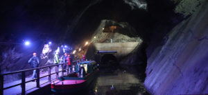
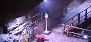
The Dudley Tunnel is over 2.5km long and accessible only by boat. The underground caves are even harder to access and difficult to map using traditional surveying technology with few places where the signal from a total station or GNSS could be used to provide geolocation. To scan in the tunnels, JPB and DCTT used one of the Trust’s smaller watercraft to carry a cross-tunnel support beam, on which a highly portable and highly-automated Leica RTC360 3D laser scanner could be mounted at different points throughout the tunnel using a prop and clamp system. Not only did this allow for the maximum amount of data to be captured, it also removed the risk of the scans being corrupted by the movements from the boat. The portal building was also scanned externally with the RTC360 on a telescopic tripod system.
To quickly scan the woodland topography above the tunnels and caverns, they used the Leica BLK2GO handheld imaging laser scanner, the fastest and easiest way to scan a large environment on foot. This was also used for specific smaller sections of the tunnels and throughout the internals of the portal building, taking advantage of the scanner’s handheld size and speed of data capture for minimal disruption to ongoing works. Finally, a Leica ScanStation P40 high-definition 3D laser scanning solution was mounted on fixed pillar positions throughout the largest cavern for detailed capture of the complex rock geometry and installed safety measures.
The Trust will use the exported point cloud data to explore the 3D models which can be used not only by the team, for example, structural monitoring, conservation recording and health and safety demonstrations, but have big plans for post-processing the 3D data into new digital visitor engagement including flythroughs, 3D printed artefacts and augmented and virtual reality experiences.
 3. Simple point cloud registration software makes it easy to manage multiple data sources – even for beginners
Developments in point cloud registration software have made it easier to take information from multiple data capture technologies and process them in one place. For the DCTT’s project, JPB used the same point cloud registration software throughout (Leica Cyclone REGISTER 360).
James Deacon, Geomatics Surveyor, JPB, explains: “Through Leica Geosystems reality capture solutions, we were able to address the topography mapping, the measured building surveying, the handheld scanning areas of the tunnels, caverns and buildings and the fast terrestrial-based scanning of the caverns, tunnels and portal environment. All solutions were brought together in one piece of software to create the required product which would otherwise require several different software suites adding time and complexity to the production of the required outputs.”
Simple point cloud management makes reality capture accessible to more organisations, reducing the learning curve of using new technology while offering the ability to create a wide variety of outputs.
Just the start of the digital transformation journey
DCCT has been impressed with its first reality capture project. The point cloud data has created new opportunities for the Trust to digitise and supplement current and future operations. Traci Dix-Williams, Dudley Canal and Tunnel Trust explain the multiple ways in which the data will be put to use: “Our goal was to produce engagement and interpretation materials for specialist and general public interest, as well as to raise the profile of the unique environment.”
Information captured will be made available on a public platform projects running in 2021, with the further objective to apply for additional funding to expand the project to include exploration of non-public areas.
 James Deacon
Geomatics Surveyor
Johnson Poole & Bloomer
Click here to read the case study from SCCS and how reality capture technology is providing innovative and safe ways to map more environments.
For more information on Leica Geosystems 3D laser scanning technology, visit our website.