


Accurate data collection is the foundation of modern forensic mapping, crash reconstruction, and public safety response. For law enforcement agencies working at the intersection of technology and justice, the Leica Zeno FLX100 plus Smart Antenna, paired with Zeno Mobile One, offers a reliable, cost-effective, and court-admissible solution for capturing evidence with centimetre-level precision.

A rugged GNSS solution built for public safety
The Zeno FLX100 plus is a compact, lightweight GNSS smart antenna engineered for fieldwork under pressure. With IP67 protection, it’s fully dustproof and water-resistant, capable of withstanding rain, mud, and other harsh environmental conditions common at crash and crime scenes. Drop-tested to 1.2 metres, it remains operational even in unpredictable terrain.
Whether mounted on a pole, attached to a mobile device, or used handheld, officers can collect high-precision geospatial data in real time without the need for complex setup or bulky equipment. Its tilt compensation capability also means evidence can be recorded in hard-to-reach or hazardous areas safely and without compromising accuracy.
Seamless integration with Zeno Mobile One
The Zeno Mobile One app enables intuitive data collection and mapping directly from a smartphone or tablet. Compatible with iOS and Android, it simplifies workflows while ensuring full integration with backend GIS or CAD platforms.

Key features include:
• Simple point collection with metadata
• Customisable forms for consistent data input
• Real-time positioning with RTK corrections
• Offline capabilities for remote locations
This makes the FLX100 plus a valuable tool not just for expert reconstruction teams but also for patrol officers, investigators, or first responders who need to document scenes accurately on the spot.
Supporting drone-based investigations with ground control
Drones have become powerful assets in the law enforcement scene documentation, providing aerial imagery that captures wide areas quickly and safely. However, for drone data to be legally admissible and accurately reconstructed in 3D, it must be georeferenced using Ground Control Points (GCPs) and checkpoints.
This is where the FLX100 plus plays a critical role. Officers can easily deploy it to record precise GCPs before or after drone flights, ensuring the resulting models are aligned to real-world coordinates.
This process enhances:
• 3D photogrammetry accuracy
• Multi-sensor data integration (e.g., drone + laser scanner + GNSS)
• Legal defensibility of geospatial evidence in court
With checkpoints, users can also validate the accuracy of drone reconstructions post-processing, giving confidence that the data meets the required standards for forensic investigation.

Read the related article: The Critical Role of Ground Control Points and Checkpoints in Drone-Based Scene Investigations
Why it matters for law enforcement
In today’s legal environment, accuracy, repeatability, and verifiability are non-negotiable. Whether it’s for documenting a complex collision, reconstructing a crime scene, or responding to a disaster, the Zeno FLX100 plus gives law enforcement professionals the tools they need to:
• Collect field evidence quickly and safely
• Achieve centimetre-level positional accuracy
• Ensure the data stands up in court
• Support rapid analysis and reconstruction
With its low learning curve, cross-platform compatibility, and rugged design, this solution democratises precision mapping for all units, not just specialised teams.
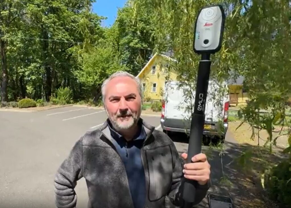 Watch the video on how William Henningsen of Collision & Crime Forensic Solutions demonstrates the Leica Zeno FLX100 smart antenna, an easy-to-use, rugged, and cost-effective tool for establishing ground control in forensic investigations.
Conclusion
From drone scene documentation to on-the-ground evidence capture, the Leica Zeno FLX100 plus with Zeno Mobile One is redefining what’s possible for law enforcement professionals in the field. It’s simple. It’s accurate. And most importantly, it’s trusted.
📌 Learn more about this topic here.
👉 Request a demo here.
Follow our Public Safety & Forensics LinkedIn channel here.