


Christopher Drye, “Chris”, reflects on the journey that led him and his company, NV5|CALYX, providing engineering and consulting services to invest in the smallest imaging laser scanner.
Since joining the NV5|CALYX surveying team almost 20 years ago, I have been involved with developing our firm’s terrestrial laser scanning capabilities. I grew up on the Leica HDS3000 and was on a panel that helped the North Carolina Department of Transportation (NCDOT) develop a workflow for scanning roadway surfaces in our state. Over the years, technology has advanced, and we are currently using the Leica ScanStation P40 3D laser scanner. This scanner allows us to accurately capture data along heavily travelled corridors that would typically be unsafe for our crews to survey conventionally. We get all the data that we need and keep our crews out of harm’s way – a win for us and our clients. We are also leading the way in using the P40 to help NCDOT check mobile lidar mapping provided by other consultants. In addition to roadway projects, we are improving our structural scanning capabilities throughout our company with the help of the Leica RTC360 3D laser scanner, Leica BLK360 imaging laser scanner and P-Series laser scanners.
Whether you are looking for a short, medium or long-range scanner, below are five tips that can help you to choose the right solution for your needs.
Tip 1: Define the applications for which you need the scanner

Back in 2017, we were working on a topographic survey for the Charlotte Douglas International Airport that involved accurately mapping the location of some very deep storm drain structures on the tarmac. We were using a cloth tape with a railroad spike on the end to weight it down to get the inverts we needed. These structures were over 30 feet deep and some had holes punched in the top of the storm system for water to leave the site. We were not able to accurately establish the size type and material of the system due to their depth. At that point, I decided to find a better solution that would allow us to accurately establish this information using laser scanning technology. My research brought me to the
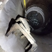
BLK360 – exactly what I was looking for. The BLK360 is easy to run, provides accurate data, and is small enough to enter areas that would typically be inaccessible by our field crews.
Tip 2: Get in touch with a sales representative
I got in touch with a Leica Geosystems representative, Matt Brown, who presented one BLK360 for a demo test run. We gathered the necessary equipment to run the BLK360 inverted and headed out to a site where we had previously been unable to map an underground storm vault because of the size of the structure and confined space issues.
Tip 3: Test the entire solution – hardware and software
NV5|CALYX’s Survey Coordinator, Justin Bennett, and I successfully scanned and mapped every detail of the structure using the BLK360 and coordinately positioned the structure using targets, site control, and Leica Cyclone REGISTER office software. All of this was accomplished without entering the system, and we were able to record highly accurate data in an extremely safe manner. We knew we were on to something, and shortly after this test, NV5|CALYX and Survey Program Manager, David Lee, agreed to invest in the BLK360. We immediately started working on a new service, Subsurface Gravity Utility Investigation, for our clients.
Tip 4: Consider the benefits and applications you will be able to provide with the new equipment
Over the next year, our team developed our workflow and QA/QC procedures for subsurface gravity utility investigation. Currently, we are using the BLK360 to safely determine the size, type of material, direction, and inverts of underground systems that would normally be inaccessible by typical survey methods. We have found buried underground junction boxes that clients didn’t know were there, identified an inaccessible bend in a culvert where the manhole lid had been buried, and mapped oversized underground structures – all with our employees safely above ground.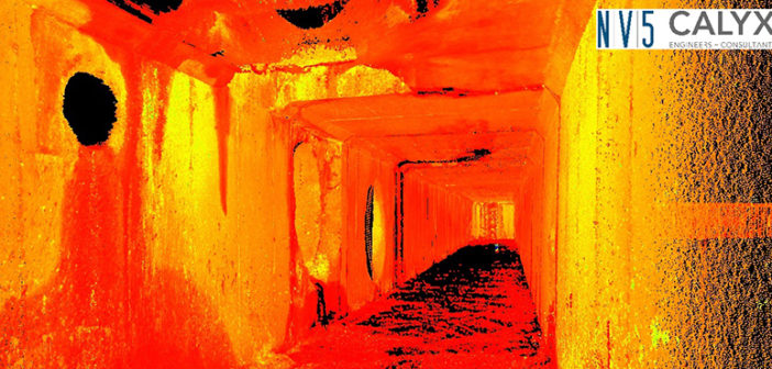
Tip 5: Reflect on the competitive advantage the new solution will bring
This latest addition to our toolbox has put our survey professionals a step above the rest. With the use of the data captured by the BLK360, our clients no longer wonder about the unknowns. NV5|CALYX is doing everything we can to give our clients all the information they need at the onset of the project so they can make informed design decisions.
Contact the BLK360 sales team or download the 3D laser scanner comparison chart to decide which one is the right for you.

Christopher Drye
Survey Project Manager at NV5, Formerly CALYX