so·lu·tion (n) – means of solving a problem or dealing with a difficult situation
To find the solution, one must first identify the problem. This may be more difficult than you first think due to various internal and external pressures within any organisation.
How to identify the problem
It has been said that knowing the problem is half the battle. Once the problem is identified, a plan can be developed, resources can be deployed, and action can take place. So, how do you identify the problem?
- Note all regular business processes
Whether large or small, a thorough review of how an organisation runs provides deep insight. While performing tasks, look for potential gains, whether it be financial, time-savings, efficiency or other. - Identify business drivers
Stop and ask “why.” Why are you sub-contracting that task? Why doesn’t the skill exist within the organisation? Why aren’t there resources for training? Discovering the answers to “why” brings you another step closer to finding the solution. - Spot issues
The final part, and the most important, is to spot any issues that are preventing you from realising the gains. These hurdles are the heart of your problems and where your plan needs to come from, where your resources need to go, and where your action needs to take place.
Recognising challenges in utility surveying
In the utilities industry, traditional methods of working are just one of the problems that can be identified using the above method. Utility providers need to be able to locate, record and measure assets to a high degree of accuracy. Traditional ways of working using measuring tapes and pencil and paper are proving a hindrance. Innovative technology needs to be embraced and used to help realise gains.
You can broadly group other challenges the utilities industry faces when measuring assets:
Environment
- Problem: Utility construction sites are almost always outside and, so being, at the mercy of the weather.
Solution: Equipment used should be waterproof and strong enough to withstand a wide range of conditions. - Problem: Sites will often have uneven surfaces and obstacles that can increase the chance of equipment being dropped or damaged in other ways.
Solution: Instruments should be robust to withstand drops and topples.
Technology
- Problem: Data capture needs to be of a high degree of accuracy to satisfy tight regulations. Using tape measures and other older measuring techniques are not accurate enough.
Solution: New technology should be able to measure positions within centimetres. - Problem: Field crews should be able to be trained easily without it costing lots of money.
Solution: New technology should be easy to use with little training required.
Workflow
- Problem: Using paper records is inefficient and costly when it comes to storage.
Solution: New working practices should be digital so data and information can be easily stored and accessed - Problem: Information often needs to be shared between different systems with the organisation or external stakeholders.
Solution: Data collected should be in an interoperable format and being able to do so in a choice of application is even better.
Efficiency
- Problem: These days all organisations are expected to do more with less, and time pressures are always there.
Solution: Embracing new technology can speed up the time it takes for data to be collected in the field to reach decision makers. - Problem: Digging locations for utility construction work can be costly business.
Solution: By having accurate records of assets, less reinstatement work has to be carried out and less roads/public areas have to be closed as a result.
A new solution for utility surveying
While all these challenges may seem daunting at first, as long as the right products are put together in one package, customers can have one solution that addresses all of the issues together. This saves money, time on procurement and training, and also provides the benefit of dealing with one trusted supplier.
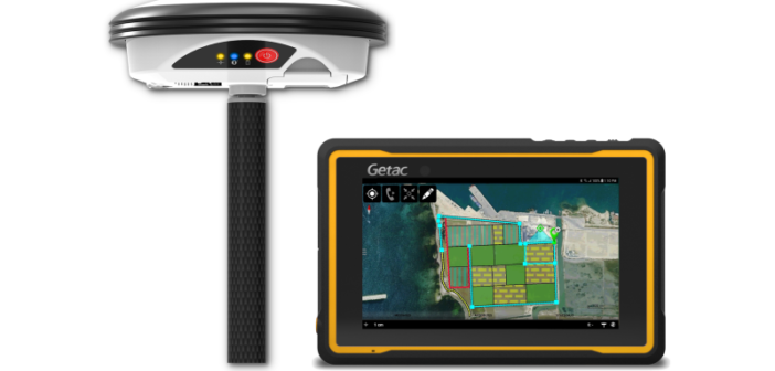
The Leica Zeno GG04 plus Tablet solution is one such package that can address all the problems discussed, by combining the best hardware and software elements of the Leica Zeno range with Leica Geosystems trusted support and services.
- The Zeno GG04 plus smart antenna can improve data accuracy with measurements of down to 1 centimetre achievable in real time thanks to the latest GNSS technology.
- The Leica Zeno Tab 1 Android tablet can improve efficiency by enabling users to work outdoors in demanding conditions thanks to its rugged and ergonomic design.
- Leica Zeno Mobile for third party smartphones and tablets can increase productivity by saving time in the field thanks to it’s simple-to-use interface and professional set of tools.
With half the battle won by identifying the problems in utility surveying, the solution is attainable with the GG04 plus Tablet. To learn more, contact your local Leica Geosystems representative.

Alexander MacDonald is an applications engineer at Leica Geosystems.


