


According to McKinsey, the construction industry has seen only a 1% increase in productivity over the past twenty years. The industry may have been on a slower path to digital transformation than others, but adoption is speeding up. Here we look at the recent breakthroughs in reality capture – namely mobile devices and real-time solutions – that are delivering instant insights to BIM. We believe this has the potential to bring considerable improvements in efficiency, with positive knock-on effects for the entire industry.
A brief history of BIM
Since its introduction, Building Information Modelling (BIM) has helped improve construction processes. It moved the industry from using 2D renderings to working from accurate 3D replicas of a site. These replicas make the detail of a site visible to other team members and any third parties involved in a build. They have uses at every stage of construction, from changing the footprint, all the way through to planning plug sockets. It’s important not to simplify BIM as just the 3D data. For example, the inclusion of time data will show the order of construction. BIM can also include information about materials. However, regardless of the objective, reality capture technology plays an essential role in the process of creating the data to form the basis of BIM.
Reality capture technology allows real-world locations to be instantly captured in detail using geospatial technology. The development of Light Detection and Ranging (LiDAR) solutions – where lasers capture millions of data points per second – improved both the speed and accuracy of reality capture and solutions based on LiDAR, and can create digital twins of spaces within minutes.
 Game-changing mobility
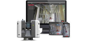
Demand for more portable and quicker solutions is driving innovation in reality capture. In hardware, devices have become lighter and able to be included in Unmanned Aerial Vehicles (UAVs), radically increasing the ground they can cover. Scanning devices have become able to operate while the user is moving, recording where they have been. The capture of instant 3D analytics is thanks to the integration of SLAM technology. SLAM is Simultaneous Localization and Mapping and does what it says – accurately following a user’s location as it maps a site. Here are a couple of examples of devices that can give real-time insights into any building or construction site:
- The Leica BLK2GO handheld imaging laser scanner. This device combines SLAM technology with the smallest dual-axis LiDAR to scan up to 420,000 points per second. We call this combination of dual-axis LiDAR, multi-camera vision system and inertial measurement unit for self-navigation, “Grand SLAM”.
- The Leica RTC360 3D laser scanner – already being used in the construction space – this device features edge computing to keep relative positioning up to date. The scanner remembers where it has been even when it has been moved around different locations. Its scans can later be combined or stitched together automatically in the field.
The second breakthrough has been in user-friendly software applications, capable of real-time processing and autonomous action. This is what we’re championing at Leica Geosystems because they improve efficiency and productivity. A couple of examples include:
- The Leica Cyclone FIELD 360 mobile-device app automatically pre-registers scan data in real-time directly in the field with the RTC360 laser scanner or BLK360 imaging laser scanner.
- The Leica Cyclone REGISTER 360 post-processing office software integrates 3D data into a user’s workflow, providing simple, guided workflows to automate registration and client-ready deliverables with the click of a button.
These latest reality capture innovations enable today’s contractors to digitise entire spaces in minutes as well as acquire and process data using purpose-built programmes. Reducing the time spent on site gives professionals back more time to spend on other tasks. Tasks that require human strategising, including fully exploring the possibilities of BIM. By capturing more detail around infrastructure, these solutions help contractors to be more efficient. They can ‘do a job well, do it once’ and use the information gathered in one visit for other purposes, like planning for routine maintenance or as the foundation for later structural modifications. In both the short and long-term, mobile and handheld reality capture technology is set to significantly improve efficiency in the construction industry.
For more information about our reality capture solutions, please contact us.
 GEOSYSTEMS Executive Vice President
Emerging Europe, Middle East, Africa and Asia
With more than 20 years of business experience, Mark Concannon serves as Hexagon’s Geosystems Division Executive Vice President for the EMEA and Asia regions. In this role, he is responsible for developing channel and M&A strategies for multiple countries, driving sales across various segments resulting in rapid growth.
Beginning his career with Hexagon in a sales role, Concannon has steadily progressed through the corporate structure. He has held managing director and senior vice president roles, introducing new technologies into markets while successfully negotiating multi-million-Euro deals. Concannon was the first president of Geosystems’ Machine Control division, restructuring the underperforming business into a successful and profitable business.