


Today’s infrastructure is extremely complex, and surveying tasks need to be done quickly, reliably, and with precision to remain on budget. This increases the pressure on companies and surveyors to complete tasks more efficiently and increase productivity.
With the ability to check the survey completeness, transfer projects from one instrument to another, and make quick decisions directly in the field, surveying field software can be your best ally in saving costs and reducing time. Yet, not all field software for surveying can provide you with the before-mentioned benefits on an intuitive and easy-to-learn interface. When deciding to purchase surveying equipment, be sure that the associated field software can deliver the benefits mentioned in this blog and help you to save costs and reduce time.
The examples below present how four different surveying companies have reduced unnecessary costs and delays by leveraging the benefits of Leica Captivate surveying field software.
Have an intuitive and easy-to-learn surveying field software
Fact #1: Training is an investment. However, by combining an easy-to-use software with familiar apps, helpful wizards, and extensive learning tools, training time can be reduced, resulting in more immediate and enhanced productivity in the field.
Captivate benefit: Surveyors only need to learn Captivate once to use it across TPS and GNSS instruments, maximising the return on investment. Staff members, learning all about how to use Captivate, will not only pick up on how to use your current instruments, but also new ones you will be adding to an expanding fleet. Learning just one field surveying software for all TPS or GNSS equipment can help tasks and projects move faster. We support surveyors to learn Captivate by delivering specific training with local specialists, free how-to videos, and quality online training.
Customer story: Titcomb associates, a thriving survey business in Maine, USA, is achieving a faster turnaround on high-quality deliverables using automated routines and simplified workflows with targeted apps in Captivate. With data that is clearly and graphically displayed and an intuitive interface, it has been quick and easy to onboard everyone in the team.
Watch what Titcomb associates has to say about this Captivating experience:
Have a standardised surveying field software across your equipment
Fact #2: Using one standard field software between surveying instruments enables a cohesive work environment and saves time when switching projects.
Captivate benefit: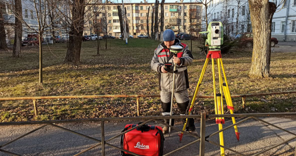 With Captivate, data from total stations, multi-stations, and GNSS sensors are collected and stored in the same way, so any crew member can operate any instrument and easily combine data from different sensor types. This means that staff can pick the right tool for any task, knowing they will be able to use it right away and review the data they create in a familiar and efficient way.
Customer story: Be it construction, cadastral, surveying, façades, or monitoring project, surveyor Alexey Petrin switches between total stations and GNSS equipment, relying on just one software – Captivate Field Software. Since all Leica Geosystems total station and GNSS instruments come with Captivate, Petrin can switch between his portfolio. With familiar workflows tailored for surveying, Petrin can focus on the reliability of the obtained data, the accuracy and the ability to work regardless of the surroundings.
“The combination of instruments helps me remain flexible and follow site restrictions – e.g. when a site does not allow to use GNSS equipment, I conduct the entire survey with a total station. This way, I really have an answer to any project requirement and can make ad hoc decisions on site. The part that wraps up the package is Leica Captivate – I find it easy to learn as it basically ‘thinks’ as a surveyor does,” explained Petrin.
Read Petrin’s story, “Why surveying is more than just a job.”
Have a field software that simplifies surveying tasks and helps surveyors experience data
Fact #3: Data insight combined with productive workflows tailored for surveyors, ensure users understand their data and tasks better than ever before.
Captivate benefit: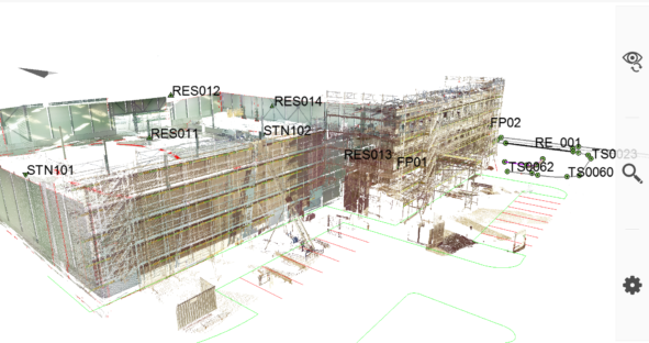 Captivate software enables fast and easy understanding for crews on site. Tasks can be better understood thanks to clearly defined workflows and tools, such as the easy follow stake instructions or the powerful coding and linework interface.
Additionally, crews on site can see and interact with all measured and design data: points, lines, scans, digital terrain models (DTMs), and alignments or data from DXF files in 3D at any location, everywhere.
Customer story: Nelson Surveys, based in Seaford, Australia, offers surveying services for some of South Australia’s largest infrastructure projects. Be it steel or concrete bridge constructions, building or road setouts, as-built reporting or volume surveys, thanks to Captivate software Nelson Surveys can tell precisely what is on site, supplying vital information for construction projects.
“Leica Captivate has brought design data to life. Users can zoom, pan and rotate, as needed, to understand any project,” explains Nelson Boquin, director of Nelson Surveys. “This 3D software gives a great visualisation of what the final finished product will look like on-site. Construction issues can be easily resolved with the aid of Leica Captivate by checking the alignment (horizontal and vertical) levels and grades.”
Read Nelson Surveys story, “Seeing the entire picture in detail.”
Have a surveying software that allows you to make decisions in the field
Fact #4: Interacting and viewing data in 3D helps surveyors to better understand and verify projects in real time. With 3D models combined with collected points, lines, and point clouds in a single view, surveyors can make decisions directly in the field by performing data analysis, such as flatness analysis and as-built checks.
Captivate benefit: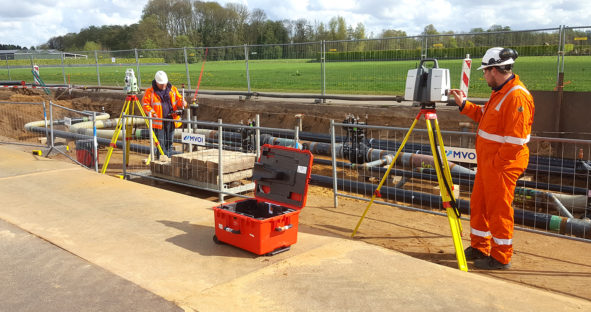 Captivate not only simplifies workflows to help surveyors achieve tasks and desired measurement precision, but also empowers them with real-time on site visualisation of collected data, enabling more informed decisions to be made.
With Captivate, surveyors can easily viewpoints, lines, point clouds and design data together in an easy to navigate 3D viewer simplifying the identification of even complicated plans. Crews can, therefore, quickly understand designs, add background images, inspect surfaces, compare data, and make appropriate decisions directly on site.
Customer story: Gasunie maintains, replaces and designs pipes, delivering gas to end customers in Netherlands and Germany. New pipe installations assembled on site are checked using a Leica GS16 GNSS Smart Antenna and a Leica MS60 MultiStation with Captivate software. The team of surveyors use the Inspect Surface app inside Captivate to look at whether there are deviations between model and as-built situation.
“The system Leica Geosystems has developed fits optimally to optimise our workflows. From the design to the final stage of a construction, this method of working reduces time and, therefore, saves money. In particular, the saved point cloud as asset information during the construction phase may become useful many years later,” said Sijbrand Stratingh, senior pipeline engineer at Gasunie.
Read Gasunie’s success story, “From the laser scanner to office in near real time.”
Read our 5 top tips on what to look for in a surveying field software or download the white paper: Lowest total cost of ownership to find out about what you need to consider when purchasing a total station.
Discover the benefits of Leica Captivate.