


 Author: Sarah Walker, Marketing Manager, PointFuse
3D modelling has the ability to transform the way we work; from construction to medicine to the gaming industry, it helps us visualise challenges in a way we never thought possible. Until recently, however, it’s been quite a beast to manage—with large files which could take weeks to process and a huge skill set required to operate the software, it wasn’t a job for the faint-hearted.
An exciting partnership between PointFuse and Leica Geosystems looks set to change all that, however. We talked to Eric Richie, Product Manager, Leica Geosystems, and Mark Senior, Director, PointFuse to find out more about PointFuse powered by JetStream (PPJ).
How did this partnership come about?
Eric, Leica Geosystems: When Leica Geosystems launched the Leica BLK2GO handheld imaging laser scanner, it spoke to a whole new group of users. The BLK2GO allows for fast, accurate and comprehensive reality capture, and the beauty is that anyone can use it—you don’t need to be an expert scanning technician. For these users, the one-and-done aspect of PointFuse was a great fit. It lets them take advantage of the powerful JetStream environment without needing a background in CAD.
 And who is it primarily aimed at?
Mark, PointFuse: PPJ is a powerful solution for anyone looking to use reality capture data more efficiently, but it is particularly beneficial for individuals or organisations engaged in visualisation, digital construction, or space/facilities management work.
And thanks to its optimisation of the transition from data capture to data utilisation, it really comes into its own when it comes to projects that need to be delivered fast—such as refitting an office or factory space for COVID-safe working.
When did you launch this solution, and how’s it working out?
 Eric: We launched in August 2020, and we’re already seeing exciting results in the field, particularly around reduced processing times and file sizes.
Mark: Absolutely. Users are typically reporting a 70% reduction in modelling time, freeing up key resources, saving time and money, as well as providing users with a scalable solution. So you are seriously reducing the file size without compromising the quality of the data.
Could you tell us a bit more about PPJ? What’s the proposition here?
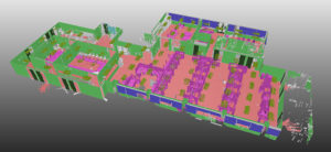
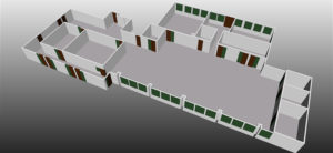
Mark: There are so many uses for this product. PPJ’s intelligent mesh models are typically being used in common digital construction workflows such as coordination and clash detection, and for visualisation purposes like site inspection and familiarisation. PPJ’s Space Creator workflow is designed as a fast and intuitive solution for users looking to create and model space both in 2D and 3D for facility management.
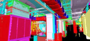 One situation that benefits greatly from this solution is where you need to share specific onsite information between a variety of design disciplines, fast. You can quickly classify the mesh data into trades and then export it to small file sizes for sharing via cloud collaboration or common authoring software.
PPJ integrates seamlessly with a variety of CAD packages, such as the Autodesk BIM 360 environment, and supports many of the common exchange formats like IFC, FBX, and OBJ.
What are the key differences between standard PointFuse and PointFuse powered by JetStream?
Mark: PointFuse powered by JetStream has the same core functionality as our regular PointFuse product but it gets extra power and speed from Leica Geosystems’ JetStream technology—it supports the LGS file format and you will really notice the speed difference as soon as you start using it. Importing LGS files is almost instantaneous compared to E57 files, so you can get to work on the fun stuff straightaway.
We’re really pleased that PointFuse is part of this JetStream ecosystem—it adds a lot of value for people who are already working with other products from Leica Geosystems since they can work from one common file, eliminating redundancy and confusion. One of these benefits is seen with the GeoTag function in Leica Cyclone FIELD 360 which provides the field team with simplified onsite asset verification. PPJ uses the GeoTag information within the LGS file format to automatically recognise and classify surfaces. This helps to minimise miscommunication between the remote site and the office.
What is the JetStream ecosystem and how does it integrate into this new product?
Eric: When we talk about the JetStream ecosystem, we’re actually talking about more than 20 products that can tap into JetStream technology to access data. That technology powers the JetStream Enterprise server product as well as LGS files, which we fondly refer to as “JetStream projects in a file.”
Leica CloudWorx was the first product to access JetStream but that has grown to include products like Leica Cyclone 3DR, the free JetStream Viewer (now known as TruView) and now, PointFuse powered by JetStream.
JetStream technology allows products to render data incredibly fast for that “all the points, all the time” experience but it also lets them collaborate with each other in a meaningful way because they are all pulling data from the same central source.
 Someone could be creating linework in AutoCAD from the same project that is being accessed in PointFuse to create an LOD200 BIM, and also taking advantage of the curb extraction and DTM functions in Cyclone 3DR—and they can have confidence that all of those deliverables are based on the same data.
Or someone could be marking up a dataset in the free viewer and then accessing those mark-ups in other products so they know where to focus their efforts.
What challenges does this product help solve, and how?
Mark: One of the key challenges people face is navigating the learning curve, both for the software and the technology. The BLK2GO handheld imaging laser scanner is really simple to use and simplicity is a theme that runs through this solution. It really changes who can be trained up—and how.
So how can people get hands-on with PPJ and put it to the test?
Mark: You can get a free 15-day trial of the product by visiting the PointFuse website (www.pointfuse.com) and you will be put in touch with a Leica Geosystems representative to get your licence. We are also offering everyone 3,000 square feet (280 sqm) of our ‘Space Creator’ export functionality so you can try out all of the software’s functionality.
Eric: If you’re ready to buy, you can contact Leica Geosystems directly to purchase the product. PointFuse powered by JetStream is being offered exclusively by Leica Geosystems but if you were to reach out to PointFuse and asked for the powered by JetStream product, they’d put you in touch with us, no problem.
And what’s on the horizon for PPJ?
We have a lot of big updates coming in 2021 and beyond, with a release taking place each quarter. We are focusing on integrating even more tightly with the Leica Geosystems Reality Capture workflow including tapping into the fieldwork side of things and further automating how our deliverables are being created by taking advantage of work that field capture teams are already doing.
PPJ will be able to utilise more information from the JetStream ecosystem within the PPJ workflows to include additional data like imagery and equal rectangular images produced by static laser scanners. We anticipate these images will aid and further streamline the classification process. It’s a very exciting roadmap, and we can’t wait to make it a reality.
Eric Richie and Mark Senior also took part in a video call with GIS Café’s Sanjay Gangal. You can check it out here.