


From robot dogs armed with cameras to long-range 3D laser scanners, advances in reality capture make it easier for surveyors to conquer hard-to-access areas. Often, survey sites are challenging: they may be dangerous or inconvenient to map, or simply be inaccessible with standard equipment. However, new solutions are changing what’s possible. Autonomous reality capture can replace humans with robots in dangerous conditions. Small mobile mapping solutions can be attached to cars, boats, and UAVs to open up better angles, while the longer ranges on static, survey-grade 3D laser scanners are putting surveyors well out of harm’s way. Here we explore how the latest reality capture technologies are solving longstanding site access challenges.
Autonomous Reality Capture Solutions: Walking Boston Dynamics Spot
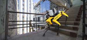 Leica Geosystems, with Boston Dynamics has introduced an agile, mobile robot solution that can complete autonomous scans of terrain that may be difficult or hazardous for a human operator. Boston Dynamics robot Spot is fitted with the Leica RTC360 3D laser scanner. Using a mobile device to control the laser scanner, users can essentially “walk” Spot through a site. The RTC360’s Visual Inertial System (VIS) technology uses five cameras to track the scanner’s movement within a site between scans. Automated workflows can be set up for faster scanning. For example, the user can trigger scans remotely via their mobile device and Spot, and the RTC360 will navigate programmed scanning paths. Once Spot and the RTC360 learn a programmed scanning route through a location, they can more easily and quickly repeat that route for regular scanning. Spot is an ideal solution for high-risk environments such as power stations, highways or natural disaster sites.
Mobile Mapping: New angles and perspectives for difficult sites
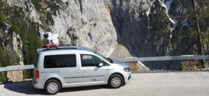 Leica Geosystems’ mobile sensor platforms enable digital reality captures from car, train, or boat, opening up creative ways to solve site access challenges. For example, Ing Geovision recently used an unconventional attachment of a Leica Pegasus Two:Ultimate mobile mapping platform to get the best view of the retaining walls of an alpine road in Germany. With a 23% slope in some places and huge drops into the valley below, the roads in Berchtesgadener Land are not easy to survey. It’s challenging to access both sides of the retaining walls, as they are built on steep, heavily overgrown terrain. Ingeniously, the Pegasus Two:Ultimate mounted to the roof of a car and to the bucket of an excavator allowed the system to hang over the edge of the wall and capture the exterior, with no risk to human safety.
Long-range 3D Terrestrial Laser Scanners: Scanning from a safe distance
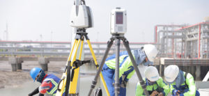 For industry professionals looking to scan inaccessible places, Leica ScanStation P50 is the fastest and safest long-range, survey-grade 3D laser scanner, delivering accurate data over a distance of up to 1km. When Vietnam’s leading port and coastal survey consultants, Portcoast, were engaged to carry out 3D mapping work at the Hyosung Vina Chemicals Port they faced several challenges, including ongoing construction work and traffic on site. Using the ScanStation P50 meant that they could scan at an elevated location away from the hazards without losing any detail.
This was not the only difficulty that Portcoast faced. The team needed to use a combination of solutions to capture everything required, including liquid tanks, pipeline systems, marine loading arm and areas and access bridge. The team used a Leica RTC360 and BLK360 to reach into narrow areas of the pipeline where the distance was only 20 centimetres. Thanks to their one-button operation design, these devices could be lowered into position using customised cranes and were operated remotely. Read Portcoast’s: 5 tips to laser scanning in a challenging environment.
UAV Platforms: Capturing complex data from above
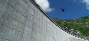 The Leica Aibot provides a complete UAV solution for surveying and mapping areas difficult to study from the ground. For example, the Axpo Group, the largest producer of electricity from hydropower in Switzerland, uses a Leica Aibot UAV solution to inspect the huge Lai da Nalps dam. Before surveying with UAVs, a surveyor had to take images from below the dam and the mountain walls surrounding it, occasionally climbing or standing inside a basket or a gondola. Even with precise planning and the perfect locations, these methods were very time-consuming, sometimes even dangerous, and couldn’t deliver as highly detailed images and quality results as those taken with a UAV facing the dam from an approximate 10-metre distance.
Our latest surveying technology is making it possible to safely and quickly capture more of our environments and is helping surveying service providers to expand the services they can offer.

Valentina Albano
Product Engineer
Reality Capture Division
Find out more about how we can help you to improve your reality capture workflow and prepare for the future at www.leica-geosystems.com