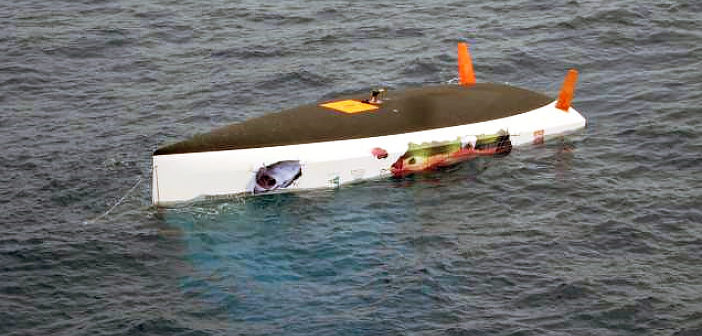
Is this truly the unhappy ending of such an amazing journey? Well, certainly for the chickens it was but was the Eco40 and the entire data truly lost at sea?
Just as you start to think the story is over – it seems to come back stronger than ever with – it appears – a life of its own…Just as the final update was ready to be posted, a mail was received from the professor…
The ESA (European Space Agency) received news that the Eco40 had been sighted and that a Spanish fishing ship off the Brazilian Coast had broadcast it on Twitter. After confirming that this was indeed a recently taken photo, the professors decided to contact the Brazilian Search and Rescue (SAR) service. It was determined that the images were already five days old and at present nobody is following the movement of the boat.
At present the Eco40 is about 700 nautical miles off of Brazil, drifting an average of 140 degrees with a speed of 0.6 nodes, in 24 days this equates to 350 miles. This route is still in the area we presumed it would be after floating with the current.
Unfortunately, it is heading out to sea not towards the coastline!
The story that was supposed to be posted earlier today is sensational enough without the “news flash” from above, so we added it here. Enjoy your read:
After the Eco40 was lost, Matteo and Professor Paolo de Girolamo of the project Roma Ocean World, organised a team of friends to help with the recovery of the sailboat. There was a satellite tracker still inside the Eco40 that was sending signals from wherever the underwater current was taking the boat. Time was of utmost importance, as the tracker would stop when the battery ran out.

Matteo Miceli (front left) together with Paolo De Girolamo (front right) and 3 other friends in Brazil organising the recovery of eco40.
After planning the complicated procedure of recovering the Eco40, as well as how to stabilise and transport the vessel once recovered, the team set out with high hopes.
A few days after setting out to recover the boat, the team began losing the tracker’s signal for hours on end, only to pick it up again if they waited patiently. However the last tracker signal had been received a day or so earlier and the team realised the battery was finally dead.
They still headed for the last known location of the vessel, assessing and reassessing exactly where the nautical recovery operation should begin. This depended on the force of the underwater current in which the Eco40 floated.
They were still roughly 30+ hours away from the search area. Without the tracker signal sending position information, the area was just too big. The team waited another 60 hours, baking in the sun, trying to search a large circular area but unfortunately found nothing.
On Saturday, April 4th, the search for the Eco40 was finally suspended. The team went home.
Yet Matteo had managed to save the removable SD cards from the Leica GR25 receiver. These cards had all the data collected up to the last time the 8GB cards were full and needed to be exchanged on February 28, 2015.
The last calculated position based on the recorded data from Feb 28 using the Leica SpiderQC software was
44° 07′ 58.38377″ S 46° 12′ 18.69666″ W
The professors in Turin and Rome now have the SD cards with the data collected from the sailor’s journey.
They look forward to analysing and passing along the results to all eagerly waiting parties.
What an amazing story indeed and should the boat be recovered, the Leica Geosystems equipment will most certainly be tested to discover just how rugged this equipment truly is.
Stay tuned…and happy winds to all!


