


Peter Glueck
Product Manager, Terrestrial Laser Scanning
Reality Capture Division
Sometimes known as a 3D visualisation, a 3D point cloud is the step before an accurate 3D model of the real world is created. It’s the starting point for digital reality, a map of points in space which are processed to become 3D models of almost any object. At a large scale, this includes buildings, factories, manufacturing plants, crime/crash scenes, civil infrastructure, historical sites, cityscapes and much more.
3D models based on point cloud data are being used in a growing number of industries for visualisation, planning and customisation. The data has the power to transform – and is transforming – the way that buildings are planned and maintained, improving the accuracy of the information available to everyone from architects to operations managers.
To increase understanding of this important technology, here we go back to basics to look at the whole point cloud process, covering:
- What a point cloud contains
- How it’s generated
- Some ways that point cloud data is used now, and
- How we predict it will be used in the near future
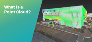 What is a point cloud?
A point cloud is a collection of an enormous number of measurements: a set of data points or coordinates in three dimensions. The measurements are usually made by 3D laser scanners and Light Detection and Ranging (LIDAR) technology. A laser measures where the light hits surfaces within its line of sight. To give a sense of the huge number of points taken, the Leica RTC360 3D laser scanner has a measuring rate of up to two million points per second. It can create an HDR-coloured 3D point cloud of its environment in under two minutes. Let’s look at how it creates a point cloud in more detail.
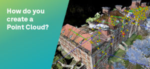 How do you create a point cloud?
The RTC360 laser scanner is portable, fast and precise, while at the same time being highly automated and very simple to use. In simple terms, the scanner sits on top of a tripod, you set it up within view of what you want to measure and start the process with a single push of a button. A high-speed rotating mirror allows extremely high measurement rates and a Visual Inertial System (VIS) with clever algorithms tells the scanner where it is – its relative position and orientation – when it is moved between different setups.
In a recent unconventional project, Top Geocart used the RTC360 3D laser scanner to capture and generate data to study and manage a 6,298-metre cave in Romania. In this example, the laser scanners were fitted with waterproof covers and transported along the river that ran through the cave system, literally drifting from scan location to location. It took the team two hours to scan at 750m per hour – sometimes in chest-height water.
There are many different technologies available to create a point cloud. Leica Geosystems offers a range of different types of 3D terrestrial laser scanner to suit different situations – Leica ScanStation P-Series for long ranges and scanning at a safe distance, through to the highly portable Leica BLK360 imaging laser scanner. We also offer mobile scanning solutions, including the Leica BLK2GO, which is handheld and designed to capture reality on the move. To help surveyors get started with laser scanning, some of our more traditional total stations also include laser scanning capabilities, for example, the Leica Nova MS60 MultiStation.
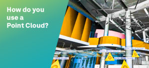 How do you use point cloud data?
A point cloud needs to be processed to create a 3D model of the reality. In reality capture terminology, you need to register and mesh the final data.
Point cloud registration is where you align overlapping point clouds – if you moved your laser scanner to different positions on site to capture a larger or more complete scene – to form one accurate model of the area. Meshing is where software converts point cloud data into triangles or polygons to represent the surface of scanned objects; the mesh stores the data of the original points, but is smaller and faster to work with.
Some of the coordinates you collected won’t be needed and further processing can filter and refine your data. For example, if you scan a shopping centre, you will capture a lot of people moving around. By enabling the Double Scan feature in the RTC360, final registration processing will remove these undesired ghost objects so that you have a cleaner, smaller and more accurate dataset.
Some point cloud processing starts while you are still on site. Leica Cyclone FIELD 360 is an app for mobile devices (iOS and Android) that connects to your laser scanner to immediately pre-register the data. Being able to visualise the data you have collected while on site means that you can make corrections or take extra scans without needing a second visit. For final registration back in the office, Leica Cyclone REGISTER 360 provides guided registration workflows to assist new users and speed the process for experienced users. For meshing and further processing, Leica Cyclone 3DR includes a range of adaptable tools that can be used to create an assortment of final 3D deliverables and reports. For project storage that enables 3D data visualisation and collaboration on the web, the new Cyclone ENTERPRISE provides a central source of truth for project stakeholders.
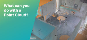 What can you do with a point cloud?
Once point cloud data becomes a 3D model its benefits are unlocked. These differ by industry and application but are mainly based on increased accuracy and safety. Let’s look at examples in a few industries where point clouds are commonly used.
Engineers and architects can use Leica CloudWorx for Revit software to efficiently and accurately create a Building Information Model (BIM) of an existing structure or update original design models with real-world conditions post-construction. When they are working on retrofit design projects, they can experience a virtual site presence and check for conflicts with the existing conditions. This helps stop critical errors in their tracks before they slow or halt a project.
In public safety projects, point cloud data can lead to more accurate modelling. For example, in Switzerland, a flood prevention project uses laser scanning to evaluate the effects of projected safety measures and experiments in landscaping. In archaeology, point cloud data can provide accurate data on existing conditions of site structures to help conservation and restoration planning or help researchers develop a clearer view of a site’s scale and layout. For example, when filming a National Geographic show about Lost Cities with Albert Lin, surveyors were part of the production team. A difficulty in studying some sites was the dense vegetation. Using 3DReshaper (Cyclone 3DR) in post-processing of point cloud data they could strip away the tree and ground cover to better visualise structural formations that had been overgrown.
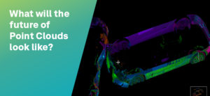 What will the future look like for point clouds?
The technology to create and process point clouds is getting progressively cheaper and easier to use. For example, ten years ago, on a construction site, it would take two or three surveyors a day to create a point cloud using a laser scanner the size of a chest freezer. Now, laser scanners like the BLK2GO fit in one hand and scans are done within minutes.
Coupled with our ability to process and store larger amounts of data than ever before, point clouds are becoming accessible to more users. In areas like construction, where point clouds are commonly used, the scale of what’s captured will increase. For example, we can now create a digital reality from a whole city mixing airborne and earthbound data captures, creating huge opportunities for the future of urban planning. We recently launched HxDR, a cloud-based, digital reality visualisation platform. HxDR creates accurate digital representations of the real world through the seamless combination of reality capture data from airborne, ground and mobile sensors. We anticipate HxDR will play a critical role in the formation of smart city and smart nation platforms that will increasingly reflect the needs of citizens today and in the future.
Point cloud data will be used in more industries via visualisation by VR. VR based on point cloud data will be more realistic, more accurate and more engaging. Not just used in entertainment, VR has many serious applications where it is useful to be at a location but may be too expensive or dangerous to visit. These include training, allowing you to learn visually and make mistakes, exploration of historical sites, without disturbing or eroding them and even investigation of a crime scene that has been cleared and no longer exists.
Finally, innovation will continue at pace in reality capture technology and in point cloud processing. It’s common for scanners to be used in UAVs and mobile mapping solutions. In the future, terrestrial laser scanners will become more automated, with users needing to spend less time on site.
Using robotics, scans could be carried out by a specialist surveyor on the other side of the world. Looking even further ahead into a world of ‘big point cloud data’ machine learning and AI will eventually automate the interpretation of point clouds. Computers will be programmed to detect certain objects in models as part of an intelligent workflow, saving a huge amount of time and increasing the amount of data that it’s possible to process.
For more information on our laser scanning technology, visit our website.
Visit our e-learning page to get started with 3D laser scanning.