


During the lifecycle of a building, it is necessary to know exactly what you are dealing with. A Scan-to-Plan workflow helps to create 2D and 3D deliverables from the collected data of the construction site. Such a workflow improves efficiency and, at the same time, save costs that would result from reworks caused by unnoticed errors. With the right hardware and software solutions for your projects, you will notice immediate benefits for your team.
Scan-to-Plan: A workflow to increase efficiency
Depending on who you ask, the term Scan-to-Plan has a different definition. Scan-to-Plan generally includes all workflows that convert point clouds into 2D or 3D deliverables. Throughout the construction project, tracking everything necessary and ensuring it is built according to plan is essential.
A Scan-to-Plan workflow could look something like this:
- Define areas that need to be scanned
- Scan the defined areas of the building
- Export the captured data into the correct format
- Import the data into a software solution
- Process the data and generate 2D or 3D deliverables
- Make improvements on or off the construction site.
You can create many deliverables from 2D sketches and linework to 3D BIM models. The resulting 2D and 3D deliverables help visualise the current situation of the building and its assets. These deliverables can be exported in different formats to be compatible with the software used to process the data further. These deliverables make it easier to make data-driven decisions to improve the workflow.
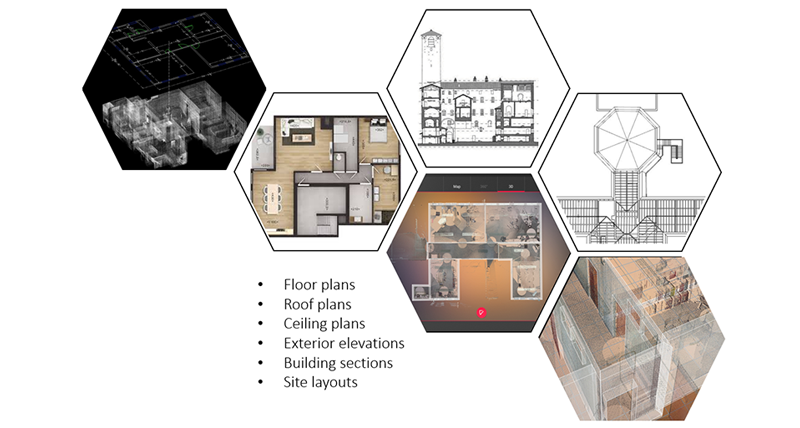
Scan-to-Plan deliverables that can be produced
Choose the fitting hardware for every task
To be able and use a Scan-to-Plan workflow you need the right hardware and software solution. There are many different solutions to choose from. Depending on the construction site and the phase you are in the needs can differ. For every task, there is a 3D laser scanner that delivers the results needed to capture the current situation of the construction site accurately.
The different scanners for a construction site can be divided roughly into five categories:
- Terrestrial
- Handheld
- Mobile
- UAV
- Robotic
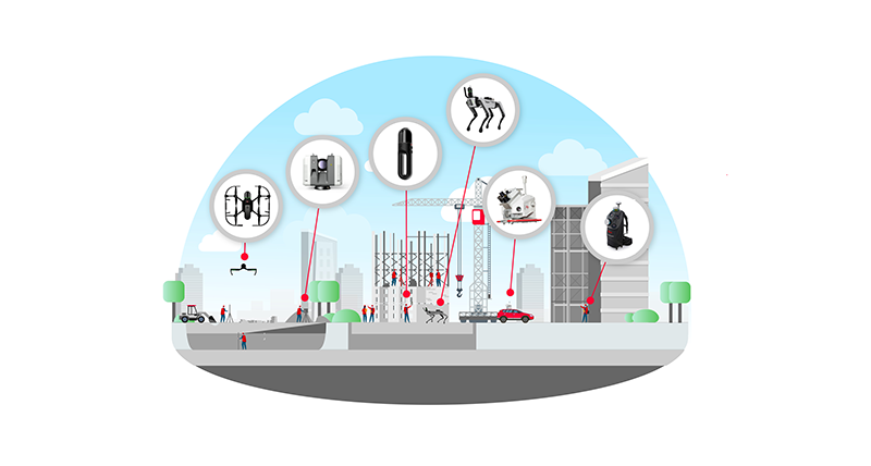
Overview of reality capture solution types for buildings
Disruptive technology, such as the Leica BLK360 and Leica BLK2GO, further democratises reality capture by making it available to a broader audience with easy-to-use products. A single-button operation of both products enables everyone to use them without vast knowledge required. The technology of the all-new BLK360 allows for fast and precise scans with 680,000 points per second (420,000 points per second with the BLK2GO and the BLK360 G1) creating an accurate point cloud of the site. Simultaneously, multiple cameras on both BLK solutions capture the surrounding area during the scanning process. This can then be combined with the point cloud for a better view of the scanned site. There are two ways to transfer the captured data to a computer effortlessly: a WiFi connection to upload it from the site to a software solution or a USB-C port. After that is done, the data can be processed within the software to create the deliverables required for the project.
Import, process and export deliverables with ease
The data needs to be processed with the construction site scanned to create the requested deliverables. There are two options to do so. One option is the legacy office software Leica Cyclone, and the other is the cloud-based platform Hexagon Digital Reality (HxDR). Both software solutions offer different ways to create deliverables.
With a broad selection of plugins for Cyclone, it is easy to find the best way to generate 2D or 3D deliverables. For example, the field companion app Leica Cyclone FIELD 360 with the Quick Plan function can track the scanning progress live and produce a deliverable in real-time at the construction site. If third-party software is used to process the deliverables, the Leica CloudWorx plugin can help. With various plugins available for different CAD software, you can export the CAD or BIM deliverables in the correct format. Leica Cyclone 3DR is a supporting tool with its guided workflows to help users create 2D plans. After processing the data with Cyclone 3DR, it is possible to either export the deliverable in the correct format or directly send it to the CAD software with a single push button within Cyclone 3DR.
The other option is Hexagon Digital Reality (HxDR), a cloud-based platform to visualise and share the captured data. This allows all involved parties to work with the latest data and base their decisions on it. The software can autonomously create specific deliverables with artificial intelligence and machine learning algorithms. One example is the automated mesh tool where HxDR uses the point cloud and generates a mesh file. More tools that autonomously generate deliverables from the data are planned and will be released in the future.
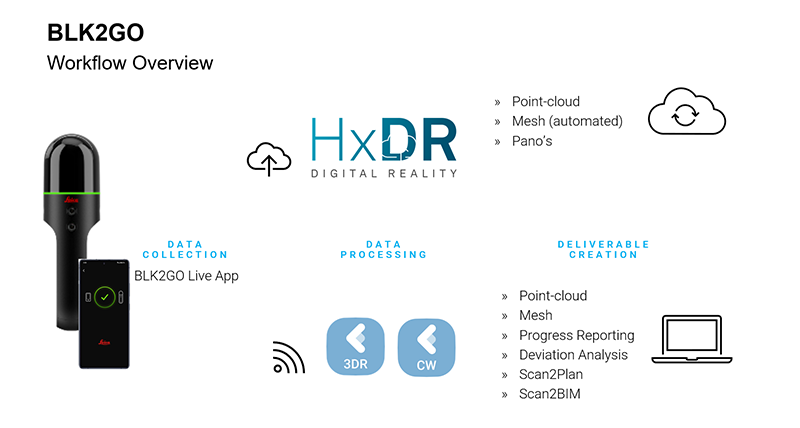
Workflow overview with HxDR and Leica Cyclone 360
How real estate and facility and property management companies create deliverables
Zibber is a real estate documentation and visualisation company based in the Netherlands that creates accurate floorplans of private and public properties using the BLK2GO. The company’s deliverables include floorplans, images, and virtual tours. As one of the first companies to use the BLK2GO for this purpose, they could create very accurate deliverables within a short period. Looking at the results, it was clear that there were considerable benefits to using this technology. The floorplans generated showed discrepancies between the original floorplans and the scans. The benefits are exciting for the clients as they can offer more accurate depictions of the building and calculate the price based on the square footage from the new floorplans.
A second company using the BLK2GO is Natisoft, a facility and property management company based in Bologna, Italy. Its services include digital as-built documentation, architectural plans, and key directories of specific assets within the building. Their database solution organises all the information in a meaningful way for their client’s properties, such as hospitals, offices, and public buildings. Adopting the BLK2GO generated many benefits for them as their productivity and accuracy increased as they could do their scans without interrupting anyone in their daily business. Using the captured data to create 2D floorplans, it became easier to show the exact location of the assets within the buildings and manage them better.

Valentina Albano
Business Development Manager Reality Capture
Leica Geosystems