Simply defined, machine control is a system that calculates the position of the tool on a piece of machinery – like the bucket of an excavator or the blade of a bulldozer – and, via a display, lets the machine operator know exactly what’s going on. It tells you how much earth has been taken out and if you have met the target depth needed for your road, for example. It’s a key part of a digitised construction site that’s making heavy construction work faster and safer. Here we give an overview of machine control and automation and outline five reasons why heavy construction can benefit from reality capture, whether you are an operator, an engineer, or a project owner.
Introducing the two types of machine control: guidance and automation
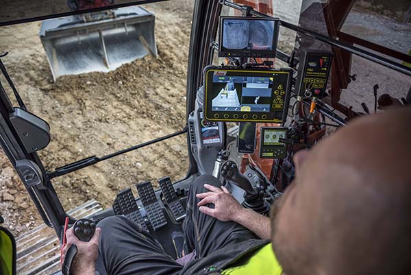
We generally split machine control into two categories. First, we have machine guidance. The system compares the position of the tool with the 3D design of the site and uses the difference between those values to tell the operator what’s going on. It’s then up to the operator to drive the machine to its required position and stop when the job is done. The 3D design normally comes in the form of triangulated surface models or digital terrain models (DTM), which are uploaded using a USB stick in the case of a single machine, or more conveniently for multiple machines, via Leica ConX, a cloud-based platform for sharing data that can be managed centrally.
Secondly, we have machine automation. Machine automation does the same calculations for the position but has an added interface that takes some of the work out of the operator’s hands. By using hydraulics or connecting to systems on the machine, machine automation can position the machine itself and meet the desired value, such as digging to the correct depth. This is generally found on dozers, graders, and paving solutions, where accuracy can be achieved much more easily than using a guidance-only system.
The trend in the industry is for guidance systems to become more and more automated. The excavator system especially has seen many developments over the past 12 months, including the semi-automatic excavator. We have drilling systems that can stop drilling automatically when the machine control tells the system that it’s hit the desired depth, and solutions for dozers and graders interface with the machines’ hydraulic system for an automated operation.

Machine operator Michael Madsen is using the machine control solution for the guidance of the excavator bucket.
How it works: positioning data
Generally, machine control requires some instruments to position itself, and there are a few ways of doing this. Firstly, in simple cases, if you’re only concerned with height, for example, you can use a rotating laser. We refer to this as a 2D machine control system. Secondly, you can use a total station tor laser scanner to acquire position and height, which is true 3D machine control. This is used for applications that require a high level of accuracy: like trimming and grading applications for roads and rail. Finally, the most common positioning type for machine control is GNSS, which will position the machine to 3D accuracy of roughly 30mm. In all these cases, the initial positioning is not done to the position of the tool itself, so there are other sensors installed to transfer the position from where the sensor sits on the back of the machine to the contact point of the tool.
![]()
Benefit one: machine operators can work more efficiently with better access to information
Machine control lets operators see all the design information on their screen in the vehicle’s car, which means they’re not relying on printed documents for levels or relying on others on-site to tell them. They can check the accuracy of their own work and easily visualise the finished product by looking at the model on the screen. All this extra information allows them to get the work right first go, reducing any rework.
![]() Benefit two: site safety is increased because people need to spend less time near machinery
Benefit two: site safety is increased because people need to spend less time near machinery
For the engineer, machine control means that there are no pegs or batteries to knock in for hours on end as the information is all there in the machine. They don’t need to have someone checking the work constantly because the operators can now check the work themselves. Therefore, the time that they need to spend near heavy machinery – a common location for accidents – is reduced.
![]() Benefit three: environmental targets are easier to meet due to more efficient working
Benefit three: environmental targets are easier to meet due to more efficient working
Machine control means that there’s less material waste as operators can be more accurate in their work. This also means less fuel is consumed, both factors in helping construction companies meet the project’s environmental targets.
![]() Benefit four: the risk of damaging utilities – and delaying the project – is reduced.
Benefit four: the risk of damaging utilities – and delaying the project – is reduced.
With the previously collected data with the Leica DSX on the location of underground utilities, you can upload this information to the machine control system and set an avoidance zone, thereby significantly reducing the risk of hitting cables or pipework and damaging a utility. It’s easy to set your avoidance zone and a trigger distance where the machine control system will alert the operator to danger. As soon as the machine goes within the trigger distance, the system sends a warning with an audible alarm, and the screen goes red.
![]() Benefit five: reporting is made easier with simple data capture
Benefit five: reporting is made easier with simple data capture
It’s possible to get data back from the machine control system in the form of measured points for the as-built reporting. The system simply creates a CSV file that populates with those points by pressing the point logging button. This can be exported by a USB stick or through the use of ConX.
Leica Geosystems’ solution for heavy construction applications offers a unified hardware platform with a common software interface across our machine control portfolio. Interchangeable between several heavy construction machines, the Leica MCP80 control unit integrates into the common software platform, Leica MC1, while Leica ConX, the cloud-based and user-friendly productivity platform for increased project efficiency, rounds off Leica Geosystems’ goal to achieve a digitised construction site.


