At Hexagon, our mission is to put data to work to enable autonomous, connected ecosystems that boost efficiency, productivity and quality for our customers.
We believe giving an accurate geospatial meaning to data is more important than ever, and to do so we develop software, hardware and services to measure precise geospatial data that enable our customers from capturing single points as precisely as possible to processing millions of data points to create digital twins of the real-world. Yet, it is our customers who give meaning to this data and make it actionable information in their daily work.
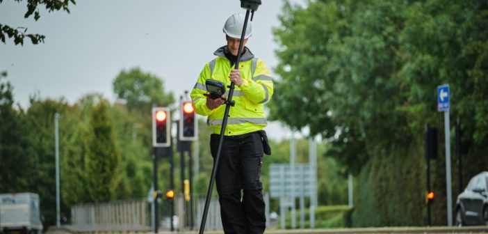
As technological innovations should aim to enhance business processes and improve workflows, we have taken enough time to understand both the workflows and business of our customers and ensure they can trust the data collected and processed. Knowing both surveyors’ needs and geospatial data workflow, we created the Leica GS18 I , a versatile, survey-grade GNSS RTK rover so powerful it enables you to measure what you see.
Measure what you see with a GNSS RTK rover?
 The Leica GS18 I is a GNSS RTK rover device: GNSS is short for global navigation satellite systems, while RTK stands for real-time kinematic positioning, a technique used to enhance the precision of position data derived from satellite-based positioning systems.
It comes equipped with all the innovative functionality of the Leica GS18 T – Hexagon’s tilt-compensating, calibration-free, immune to magnetic disturbances GNSS solution – plus the power of survey-grade Visual Positioning, which makes it suitable to capture points from a safe distance that couldn’t be reached before.
With the new GNSS RTK rover, we address a number of challenges surveyors have to overcome in the field. It has been a challenge for surveyors to efficiently and safely measure points of interest that don’t have a direct view of the sky or points that are inaccessible or located in hard-to-reach areas. Also capturing an entire area of interest in the field quickly and measuring the required points later in the office has not been possible before when using a conventional GNSS RTK rover. Like any GNSS RTK rover, GS18 I can be used anywhere where GNSS satellite signals can be received. However, since GS18 I has an integrated camera, users can use it to capture and measure points that are up to 10 meters away (that can be under a canopy, across a busy street, down in a deep trench and so on) from it by capturing the site in images.
In a nutshell, the GS18 I can capture and measure points from a safe distance where previously the surveyor would have to go into dangerous areas to take these measurements. In some situations, it might not be so clear which object is of interest. With the GS18 I the entire area of interest can be captured, and the measurement can be done later in the field or the office.
One rover, many applications
 The GS18 I is ideal for a variety of environments and applications, including survey and mapping, utility services, and public safety. One example of a use case is in crash scene investigations: With the GS18 I, the complete collection of data in the scene of a crash is done quickly and accurately. Users don’t need to disturb the evidence and they will have all details captured for further measurement. Because the data is collected efficiently, the scene can be cleared and no evidence is missed.
Overall, Visual Positioning technology opens up possibilities to reach the points that couldn’t be measured before solely with a GNSS RTK rover. We are certain our customers will discover new ways with the GS18 I to put data to work that we haven’t even thought about ourselves.
How to work with the GS18 I
Using the new rover is pretty straightforward. To measure points, the user simply needs to walk past the object being measured and choose the images containing the point of interest. By tapping on a point within an image, the global coordinates are calculated with survey-grade accuracy. The user needs to pick the point only in one image and the system matches it with the same point in other images. To make measuring on-site more efficient, we have also created some helpful functionalities, such as a snapping tool that automatically chooses the closest corner from the point user tapped. This makes selecting the right point even faster and easier.
This collection of videos will show you how to get started with the GS18 I in four simple steps.
Step 1: Capture an image group with the Leica GS18 I GNSS RTK rover.
Step 2: Measure points in images with the Leica GS18 I GNSS RTK rover.
Step 3: Add and remove points when measuring points in images with the Leica GS18 I GNSS RTK rover
Step 4: Process images captured with the Leica GS18 I GNSS RTK rover with Leica Infinity office software
Join us at HxGN LIVE Global 2022 June 20-23 in Las Vegas at the #PureSurveying Summit where you will learn how you can “Put Data to Work” with innovations like the GS18 I and network with people in your industry.
Visit the Pure Surveying website to get inspired to grow your business and upskill your staff.


