


A quiet morning at a small café north of Toronto quickly turned deadly when a gunman entered the establishment and opened fire. After 11 shots were discharged in seven seconds, the carnage left behind killed a customer and barista and seriously injured two other customers.
The chaotic scene was immediately investigated by the Forensic Identification Unit (FIU) of the York Regional Police. With eight investigators on the scene for three days, the authorities focused their efforts on trajectory analysis.
Using the laser scanning innovation of the Leica ScanStation along with the measurement technology of the Leica DISTO™, 18 scans along with hundreds of measurements of the interior and exterior of the café were captured during the forensic collection phase of the investigation. The ScanStation scan data and DISTO™ measurements were then registered and imported into the Leica Map360 crime scene diagramming and reconstruction software for trajectory analysis.
The latest version of Leica Map360 is now out with three new editions to digitise and document any crash or crime scene.
Detective Sergeant Brad Joice, the FIU officer in charge, outlined the team’s method to collect and then analyse the evidence in the recent webinar A Successful Technique for Integration Digital Crime Scene Data.
- Freeze and preserve the scene
As with any crime scene, contamination is a concern. As quickly as possible, the York FIU entered the scene and immediately began scanning. The laser scans freeze the scene in time, preserving evidence to be revisited much later when court trials begin. - Identify impact points
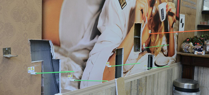
 On the wall of the café, there were six bullet impact points that were suitable for trajectory analysis. In this process, two points of contact are required to validate the trajectory. The first in this case was the wall, and the investigators then cut the wall to use the surface behind, a block wall, as the second point. Rods are placed in the impact points to easily identify paths.
- Scan again
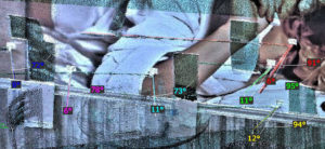 After trajectory rods were placed in the impact points, the team again took comprehensive scans of the scene. In Map360, the investigators could then easily and visually measure horizontal and vertical angles within in the point cloud.
- Analyse the evidence
Tagging every piece of evidence, creating point cloud models of the scene, mapping out the path of the bullets – all this and more is possible within Map360. Joice and his team created 2D models, as specifically requested by the prosecutor, from the point cloud for trials exhibits. The detailed evidence report was also able to be created and tracked within Map360. Using the trajectory tool in Map360, the analyst simply clicked on the rods to elongate them to 5-degree cones to better understand the bullet path. - Bonus – overlay point clouds on video
 Partnering with iNPUT ACE, Leica Geosystems is able to offer public safety customers the ability to overlay point clouds onto video for a new and even more detailed scene visualis The heinous shootout was captured on surveillance video installed in the café. Using that video plus the point clouds captured with the ScanStation and analysed in Map360, iNPUT ACE software is able to make a transparent video that brings all the evidence together in one view.
Returning to the scene of the crime
“One of the greatest advantages to using a 3D laser scanner is that you collect and capture data that isn’t significant at the time but becomes important later,” said Joice.
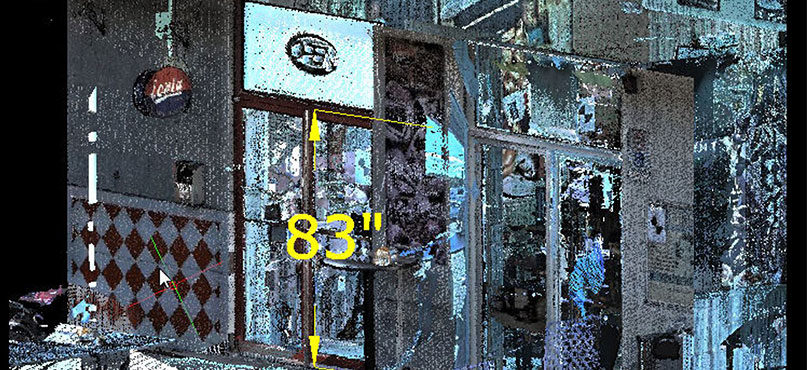
When the case went to trial two years after the incident, part of the defense’s strategy was the height of the accused. Arguing his client was much taller than the suspect in the video, the defence attorney questioned the validity of the prosecution. Using the laser scans that captured the door frames of the café, the prosecution was able to challenge this argument with factual height measurements that more accurately determined the suspect’s height. Furthermore, by the time of the trial, the establishment had undergone renovations and re-opened as another business. The door frames were no longer in the same place nor structure. Without the captured laser scanning data, investigators would not have been able to go back to the scene and re-measure.
The accused was convicted of first-degree murder of the two deaths and is currently serving a life sentence.
To learn more about using laser scanning for crime scene trajectory analysis, watch the webinar A Successful Technique for Integration Digital Crime Scene Data. For more information on Leica Geosystems 3D laser scanning solutions, please contact us.