


Businesses around the world are starting to take advantage of new and improved mobile mapping systems. These advanced systems provide exceptional efficiency and accuracy, and they enhance the safety of projects, all while offering versatility and innovation to project delivery.
The business of surveying has changed for the better, making it more inclusive and accessible to non-surveyors. In the past, this kind of advanced technology was only available to big businesses and those teams with extensive technical knowledge. But companies such as Hexagon have changed this by providing comprehensive, time-saving, cost-efficient solutions for all; from the surveyor who is just starting out to the multi-national managing projects worth billions. Everyone can make better, more informed decisions.
In this blog, we’ll explain why you should invest in a mobile mapping solution, how this technology is already helping customers around the world, which system to choose, and how Hexagon is supporting individuals and businesses at all levels.

Why invest in a mobile mapping system?
Mobile mapping systems are beneficial for many reasons: efficiency, accuracy, safety, versatility, and innovation. The Leica Pegasus TRK solution is incredibly efficient as it has been specifically developed to collect large amounts of data quickly. This saves time, money, and resources. For example, Hexagon recently worked with a customer in Germany who had previously spent two months collecting data, but it only took half a day to collect the same data set using a mobile mapping solution.
For mobile mapping applications absolute accuracy is important in order to deliver reliable data. Every product in the Pegasus TRK portfolio, including the new Leica Pegasus TRK100, offers high levels of accuracy as standard. Enhanced safety provides benefits for users and civilians. Reliable, accurate, vehicle-based solutions mean operators can map harsh or hazardous environments without compromising their well being. And as a lightweight option (minimum weight 14 kg), the versatile Pegasus TRK portfolio can be adapted for any vehicle.
In addition, the innovative technology behind the products (hardware and software) is a selling point for businesses when they’re recruiting. Digital natives and the Gen Z workforce are attracted by working with easy-to-navigate systems as they’re familiar with state-of-the-art, intuitive software.

What does a mobile mapping system offer compared to other surveying tools?
Mobile mapping systems make the collection of accurate data fast, easy, and safe. While the accuracy of products within the Pegasus TRK portfolio is on par with traditional data capture tools, the biggest difference is in the completeness of the data captured. Plus, mobile mapping is far less intrusive. For instance, when operating in densely populated areas, data can be captured from a distance while protecting the privacy of residents. People, cars, and motorcycles can be blurred out instantly.
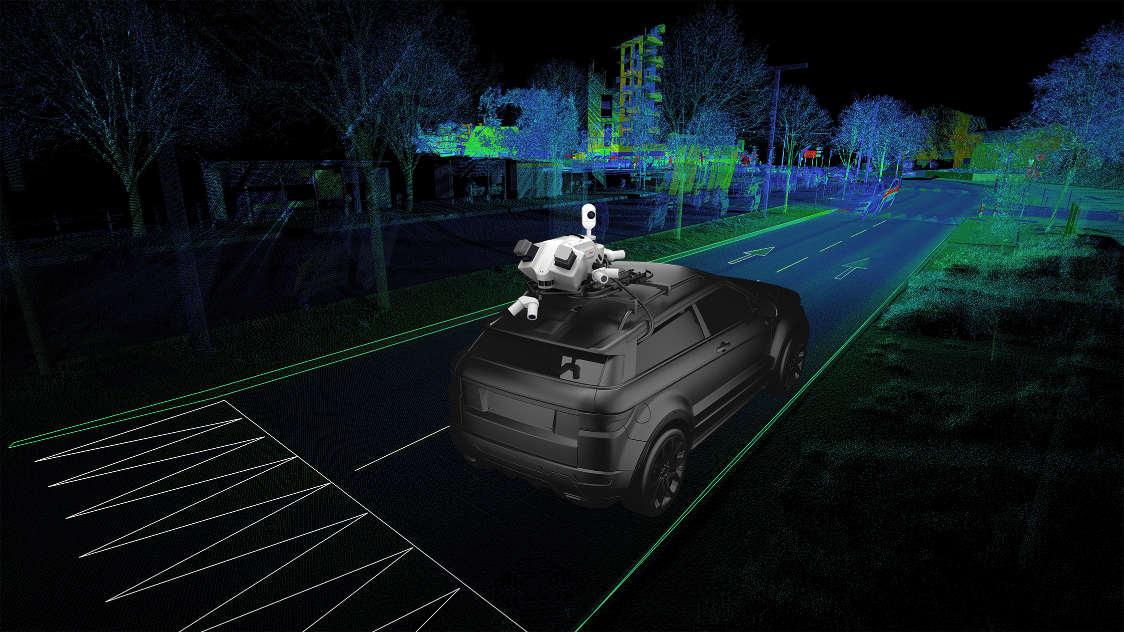
Instead of creating a single data point, as with traditional surveying techniques, Hexagon’s technology enables users to capture millions of data points through its’ enriched 3D point cloud technology, which is further enhanced by the 360° image capture technology.

The Leica Pegasus TRK500 Neo features a 360° Panoramic Camera and can capture 500,000 points per second. The Leica Pegasus TRK700 Neo, with dual scanners, can capture one million points per second. This high-res data can then be transformed into 3D models or a Digital Twin. Data from Pegasus TRK systems can be uploaded to Hexagon’s Reality Cloud Studio, powered by HxDR, which is a cloud application for reality capture data visualisation, collaboration, and storage. Users can simply upload their data to the cloud for data processing, storing and creation of photorealistic digital twins, and to share data with project collaborators quickly and securely.
Technology is constantly evolving, and so are mobile mapping systems. Artificial Intelligence (AI) is already being used to anonymise data, but in the future, it will recognise and populate more elements in a database. A key advantage of AI is the ability to process and analyse data in real time.
How does Hexagon help customers choose a mobile mapping system?
The key to finding the right solution for any customer (existing or potential) is to understand their issue: is it time, accuracy, safety, or volume of data to capture? What is their budget, and what accuracy is required for their deliverables? Gathering as much information as possible enables the Hexagon team to provide the right solution.
For new users, the Pegasus TRK100 is ideal because it captures point cloud data and accurate images quickly. It’s a lightweight, powerful yet easy-to-use, automated system, making it ideal for those who want to gain experience and transform their business. It’s comparable to the wearable Leica Pegasus: Backpack, which is also lightweight and designed for data capture indoors, outdoors, underground, and in areas a vehicle can’t access.
Other examples of different solutions meeting different applications include a customer interested in capturing power lines. In this case, the Pegasus TRK Neo was recommended because the LiDAR technology is better suited to this type of data capture. However, for engineers or the rail industry where customers need the most accurate point cloud data, the Leica Pegasus TRK Evo would be preferable. There are two options within the Pegasus TRK Evo product range, the Leica Pegasus TRK500 Evo, which offers a single scanner capable of one million measurements per second using a single line point cloud pattern, or the Leica Pegasus TRK700 Evo with a dual scanner capable of capturing two million measurements per second via a crossed line point cloud pattern.
There are subtle differences between the products within the Leica Pegasus TRK portfolio, so the team will guide customers toward the best solution for their project. This tailored approach recognises the individual needs of each customer.
Live demonstrations show customers how simple, autonomous, and intelligent the products really are. This often takes place at the customer’s site, so the system can be tested in the locations they need to map. Or they are invited to Leica Geosystems in Heerbrugg, Switzerland, which is the base for product management and development of the mobile mapping solutions.
Another benefit is every Pegasus TRK system can be upgraded. While a new user might opt for the TRK100 initially, as their business grows and project demands increase, they can upgrade to the TRK500 or TRK700 as there is a consistent workflow and software across the portfolio.
From traditional surveying to mobile mapping: when is the right time to invest?
For customers who have experience in surveying, the learning curve is not as steep as they know how to use elements such as coordinates and point clouds. Since the Pegasus TRK system was launched, Hexagon has reached far more customers, including non-surveying firms. This is because users don’t need to know about GNSS and point cloud data in detail and all the other complex elements of traditional surveying. Hexagon has automated and simplified the data collection process, making it easier. And users are supported by an immersive, online learning platform.
An example of a non-surveying company that has leveraged this technology is an optical fibre company in Italy. They’re a FTTH (Fiber to the Home) supplier working for telecom companies and part of their remit is to determine what infrastructure is already in place, and where they can deploy to reach a determined customer base.
Working in busy city environments in this case, using an on-vehicle set up is helpful in combination with the Leica BLK2GO Handheld Imaging Laser Scanner, which enables users to access areas a vehicle can’t. This example highlights the benefits of combining different reality capture systems to get a comprehensive, accurate data set.
How to make the business decision to invest in a Mobile Mapping System?
Mobile mapping is transforming surveying because of how efficient and accurate the data capture methods are. Hexagon recognises this and the need for technology to be accessible, user-friendly, automated, and intelligent.
That’s why it offers something for everyone and supports businesses at every stage. With Hexagon’s true upgrades, a business can invest in increasingly advanced mobile mapping systems as it grows. So, the question isn’t how to decide to invest in mobile mapping, it’s when.

Raphael Goudard
Global Mobile Mapping Segment Manager
Leica Geosystems, part of Hexagon