Railways connect users to their workplace, homes, service and entertainment centres, restaurants and beyond. Rail transport systems linking suburbs to city centres are essential for economic and social development. Countries are adapting and expanding their railway systems to mobilise the increasing urban growth and keep the economy on the move – Spain is no exception.
Ferrovial Agroman builds and maintains current railway infrastructures through which millions of people and goods flow. Since 1927, Ferrovial Agroman has laid more than 5,300 kilometres of railway in Spain, including 1,000 kilometres of high-speed rail lines in and outside the country.

The Railways and Transport Department of Ferrovial Agroman is involved in the maintenance and construction of railway lines throughout the Spanish territory. Among all these projects, the recent completion of two high-speed line stretches belonging to the Northwest High-Speed Corridor connecting Madrid with Galicia stand out:
- The construction of the Espiño tunnel
- The assembly and maintenance of the railway superstructure between Olmedo and Zamora.
With this amount of projects, Ferrovial Agroman needed to streamline the process of acquiring data and verifying information. The challenge was solved using a mobile mapping system that captures the railway and all its environment with the speed and efficiency that most rail projects require – the Leica Pegasus:Two.
Overcoming rail riddles
Railway tracks are purpose-built – each track is meant to smoothly guide a specific train, built with the highest specifications, so both pieces of the puzzle fit neatly together. Nothing else but the train can run or stand in the way of a railway. Surveying a railway line, therefore, requires capturing enormous amount of data with the highest precision and standards in the shortest amount of time.

In addition to the usual challenges of surveying a railway, the railway lines in Spain that Ferrovial Agroman oversees are defined by a mountainous landscape with numerous underground works and inaccessible areas. At approximately 8 km, the Espiño tunnel is one of the underground works with the longest corridor distance. The Northwest High-Speed Corridor project, which links the Spanish cities of Olmedo with Santiago de Compostela, has more than 400 km of track assembly, of which 100 km correspond to the Olmedo and Zamora section.
“Conditions to capture railway lines are challenging. If, in addition, the project is a railway line that is in service with limited work times, the speed of acquisition is key,” said David Rodríguez Vega, head of geomatics and topography at Ferrovial Agroman. “Having a system that captures data in a flexible and fast way is key to solving the problems that arise in a new project. The perfect ally to fulfil our goal is the Pegasus:Two, the most efficient and fastest mobile mapping system.”
Speed and precision
Ferrovial Agroman is aware that digital representations enable professionals to make more informed decisions. For the correct execution of rail projects, it is required to have detailed digital data of all assets that form part of the railway infrastructure. To create accurate 3D models that fuse plans with the mirrored reality, experts rely on the Leica Pegasus:Two.
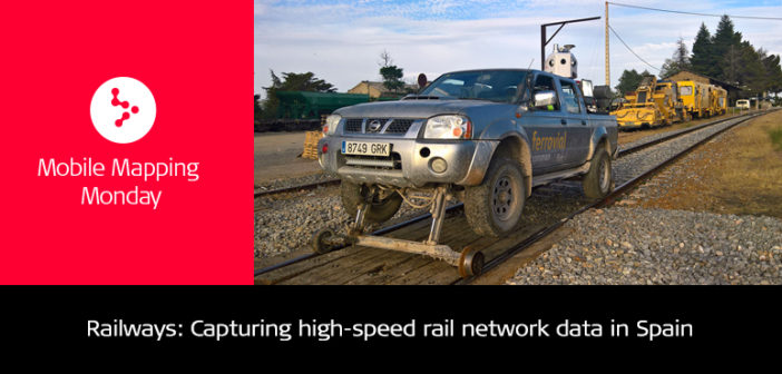
To interfere as little as possible in the railway line, the Pegasus:Two is mounted on a vehicle suitable for driving on roads and rail lines, providing flexibility to leave and occupy the line.
“Having a system that provides speed and quality in the acquisition of information is decisive. The georeferenced point clouds with overlaid images obtained with this mobile mapping system have exceeded expectations and will undoubtedly be applied to new projects,” said Rodríguez Vega.
With a mobile sensor platform that captures not only point cloud and 360° imaging data from additional sensors with survey grade accuracy but incorporates GPS and Inertial Measurement Unit (IMU) positioning systems, quality of information is guaranteed.
“Our end goal is to digitalise railway lines to have all the elements that are part of the infrastructure identified geolocated, and geometrically defined. All data and models generated is the basis for all future projects,” said Rodríguez Vega. “It is without a doubt a great advance towards the digital world – an end that our main clients are demanding.”
Above the rest
The team of experts considered speed and quality of information as the main criteria when selecting a solution to capture their railway projects. Within the commercially available mobile mapping systems, Ferrovial Agroman selected the Pegasus:Two with its specific trajectory calculation software, Leica SiRail, due to several factors that made the mobile sensor platform stand out above the rest:
- Compactness and ease of transport
- Precision with the most advanced GPS systems and IMU inertial systems
- Simplicity to assemble and disassemble the system in the vehicle, calibrate the system, and a control software that is intuitive and easy to use
- Geosystems’ commitment and effort in achieving the success of the project.
A partner you can trust
More than 90 years of experience and 55 years of international activity in 50 countries spread over five continents have made Ferrovial Agroman a leading company in the infrastructure sector.
Ferrovial Agroman trusts Geosystems solutions for large infrastructure projects with outstanding underground works, large assembly projects, and track maintenance where the details are very rigorous.
The company currently uses a wide range of Geosystems software solutions from Leica GeoOffice, Infinity, GeoMos and Cyclone, to CloudWorx plugin for 3DReshaper.


