


Surveying service providers are increasingly adding 3D laser scanning and other reality capture equipment to their technology toolbox, and for good reason. Laser scanners capture comprehensive data on buildings, infrastructure and environments through 360-degree images and millions of accurate measurement points collectively known as point clouds, allowing the captured data of various sites to be documented quickly and analysed directly in the field for QA/QC measures.
As the popularity of the technology has accelerated, so, too, has the proliferation of scanner types and brands. A quick search online or in social media pulls up a number of different options, with various claims regarding speed, accuracy and quality. How can you determine which laser scanner is the best fit for your application?
A little knowledge on the key considerations in choosing a laser scanner can go a long way toward helping you make a wise investment that will make your company more efficient and more effective for years to come. Here are seven capabilities to evaluate before you make your purchase.
1. Scan speed and image capture
One or two million points per second sounds impressive, but, what does that mean in real-world terms? What happens to the scan speed when you want a full-dome image capture of a scene along with the scan data? What if you need full-dome High-Dynamic Range (HDR) imagery to see minute details in shadows or bright light conditions – how does that affect the speed of data capture?
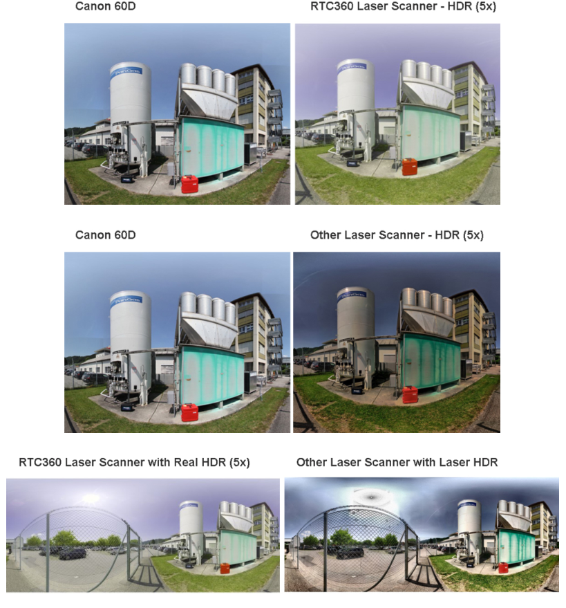
Knowing the field performance of a highly rated laser scanner can be useful for comparison. For example, the Leica RTC360 3D laser scanner scans at two million points per second (pps) and captures a full-dome HDR image in one minute. This means you can complete a full high-resolution scan (3 mm) of your scene at a 10-metre range in less than three minutes with true HDR imagery. Running the scanner at maximum speed without HDR images allows you to complete scans in less than 30 seconds.
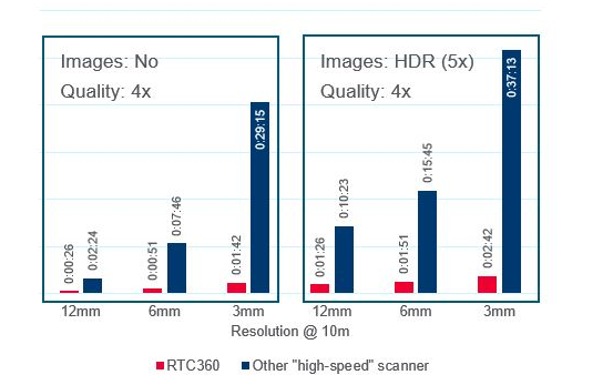
True vs. laser HDR: If you plan to use HDR as part of your scanning procedure to document your environment, be sure to check the source of the imagery. With real HDR imagery, high-resolution cameras collect high-quality source images that are overlapped so they can be blended together easily. Some laser scanners combine non–HDR imaging with laser intensity values to create more contrast in the colourised point cloud and a panoramic “HDR” image. While this approach can speed up HDR image capture in the field, it slows down processing in the office when working with the high–resolution scan data. Laser-based HDR images also lack natural colours, which can be important to the project.
When evaluating a laser scanner, look at how the scanning speed translates to the work you do every day.
2. The data quality of the scans at high speed
Data quality is important, but it’s not always an easy parameter to measure when comparing laser scanners. To get an accurate assessment of data quality, ask for a high-resolution demo scan of an area at a 10-metre range that includes complex surfaces, and evaluate the data on the following key points:
Completeness. Is any data missing? Focus especially on areas where the angle of incidence is flat; the data should be just as complete here as in other areas of the scan.
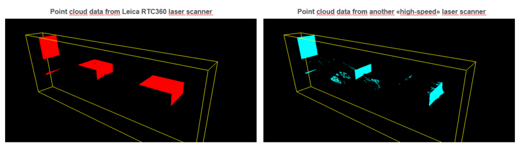
The point cloud from the Leica RTC360 is complete and clean, with no invalid points (left). The point cloud from the other high-speed laser scanner is incomplete with invalid points (right).
Cleanliness. The data should be clean and crisp, with no invalid points “floating” in the scan data.
Geometric Accuracy. The geometry of scanned objects should be correct. Watch for rounded edges.
Range Noise. On some laser scanners, achieving clean, high-quality scan data with low range noise requires significantly slower scan speeds. A laser scanner is not really high speed if it takes hours to complete a high-quality scan. Check to see if the laser scanner requires you to determine the amount of noise acceptable in your data and then choose the corresponding quality setting. If so, be aware that this process will add time and affect the geometry of your resulting scans. A better approach is to use a laser scanner that delivers the best quality automatically, without adjustments and without compromising scan speed.
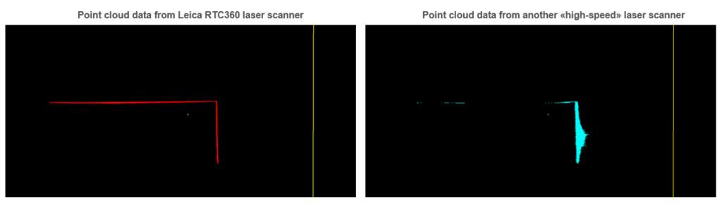
The point cloud from the Leica RTC360 is complete with low range noise and correct geometry (left). The point cloud from the other high-speed laser scanner (right) has high range noise at areas with a perpendicular incidence angle and holes in the data at areas with a flat angle of incidence. The geometry of the scanned object is also incorrect.
Mixed Pixel Filtration. How well does the scanner filter out invalid points (mixed pixels)? Look for groups of invalid and unfiltered points in the data. The data should be clean and well filtered.
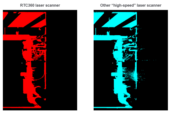
Mixed pixels between pipes, cables and wall are filtered well in the Leica RTC360 data (left), while a group of invalid and unfiltered points can be seen on the right in the data captured with the other high-speed laser scanner (right).
3. The image quality of the scanner
HDR images should be photo quality. Images that are too dark or too light can obscure important scene details. To evaluate image quality, compare images from the scanner with images captured by a high-quality DSLR camera.
4. How accuracy is determined
Information on accuracy is easily found on spec sheets, but more important than the numbers is how that accuracy is achieved. If the scanner requires onsite compensation, this has to be done at every scan position. Keep in mind that 3D positional accuracy is only known if the angular accuracy is known. Without true onsite compensation, you are scanning with unknown 3D positional accuracy. Also be aware that if measurements are only done before and after the scan with an average tilt applied to the complete scan during import, this is tilt measurement, not real-time dual-axis compensation. Be sure you understand how the accuracy numbers for the scanner are determined before jumping into your purchase.
5. Data management
High-speed, high-quality laser scanning gives you the ability to capture a lot of data very quickly. If the scanner relies on an open-format SD card to store and transfer this data, you will quickly max out your storage space. SD cards are also limited in temperature stability. Look for a data management system that enables you to store hundreds of gigabytes of data, transfer hundreds of megabytes of data per second and can withstand extreme low and high temperatures.
6. How in-field pre-registration is performed
If the scanner provides in-field pre-registration, what does that process look like? Is it based primarily on software, or does the scanner hardware also play a role?
Ask about the computing requirements – can you use an iPad in the field, or do you have you use a high-performance tablet or notebook? Can you optimise the registration and enrich the scan data by adding geotags and other information, or does the software limit your interaction with the data? Can you track the live position of the scanner in the field and visualise the scan data to make sure you’ve captured everything you need before you leave the scene? How long does it take to process the scan data before it’s registered?
 Keep in mind that automatic in-field pre-registration is only as good as the complete data flow of the system. A software-based system that isn’t optimised for data processing can create bottlenecks in your documentation workflow as you wait for the system to register scans, especially when scanning in colour at high resolution. Without the ability to perform some manual adjustments, you might have to rescan some setups if they don’t register correctly in the automated process.
To optimise your efficiency and results, look for a scanner with an in-field pre-registration system that integrates software with hardware, such as internal cameras and an Inertial Measurement Unit (IMU).
7. Integrations with other reality capture and digital mapping solutions
The need to capture complex and sometimes inaccessible sites is often critical to support your project requirements. While companies increasingly consider high-speed 3D laser scanning to be a critical piece of reality capture technology, it’s not the only tool for this purpose. Easy-to-use and highly portable terrestrial laser scanning systems that operate at the touch of a single button provide a simple way to move from 2D to 3D workflows.
Mobile mapping systems enable reality capture of large-scale environments. Unmanned aerial systems (UAS, also known as drones or UAVs) provide a way to capture alternative scene perspectives and provide access where physical entry is restricted. And purpose-built software solutions streamline efforts by turning digital data into accessible visualisations and intelligent diagrams and maps.
We can help you make sense of reality capture so you can make the best decisions for your company and advise your clients today to discuss your needs.
Discover our 3D laser scanning solutions for surveyors
By Hans-Herbert Tuexsen