


From crime scene documentation to disaster response, accident reconstruction, and search & rescue, public safety teams require reliable, high-precision geospatial data. Discover how Leica Geosystems integrated solution empowers professionals to collect, manage, and share critical scene data with confidence.
Understanding the Leica Zeno solution

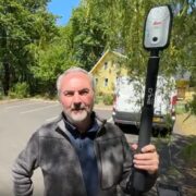
The Leica Zeno solution is a comprehensive system designed to deliver survey-grade accuracy and operational flexibility for field data collection in public safety environments. It comprises three core components:
- Leica Zeno FLX100 plus smart antenna:
A rugged, lightweight GNSS receiver that provides centimetre-level accuracy, even in challenging conditions. Its tilt compensation technology allows users to record precise locations without needing the antenna to be perfectly vertical, making it ideal for hard-to-reach or hazardous areas. - Zeno Mobile One app:
An intuitive mobile application for Android, iOS, and Windows devices, enabling users to capture, visualise, and manage geospatial data. Features such as multi-collect, background mapping, and seamless integration with GIS platforms (e.g., ArcGIS Online/Enterprise) streamline fieldwork and data management. - Zeno Connect:
A connectivity app that acts as a bridge between the FLX100 plus antenna and your mobile device, ensuring high-accuracy GNSS data is streamed to your chosen application. Zeno Connect supports real-time corrections, flexible configuration, and integration with third-party software via API/WebSocket.
Together, the components transform any compatible mobile device into a high-precision data collector, supporting a wide range of public safety applications.
Real-world public safety applications
Crime scene documentation

Accurate geolocation of evidence is crucial for forensic integrity and legal defensibility. The Leica Zeno FLX100 plus, paired with Zeno Mobile One and Zeno Connect, enables investigators to:
- Precisely record the location of evidence markers, body positions, and environmental features, even in tight, hazardous, or hard-to-reach areas, thanks to tilt compensation and rugged design.
- Capture ground control points (GCPs) and checkpoints for drone workflows, ensuring aerial imagery and 3D models are anchored to real-world coordinates.
- Create court-admissible, traceable digital records that support forensic analysis and withstand scrutiny in legal proceedings.
Expert insight: Will Henningsen, Forensic Manager, demonstrates how GCPs measured with the FLX100 plus align laser scan and drone imagery, enabling comprehensive, survey-grade reconstructions for crime and collision investigations.
Accident reconstruction

For crash scene investigations, the workflow supports:
- Precise measurement of vehicle positions, debris, skid marks, and ground control points for photogrammetry and 3D reconstructions.
- Validation of drone-derived models using GCPs and checkpoints is critical for legal admissibility and forensic accuracy.
- Integration with mapping and CAD platforms for seamless reporting and sharing with insurance companies, legal teams, and other stakeholders.
Expert insight: Geomatics expert Assay Burke and former state trooper Kevin Kinney emphasise that skipping ground control is the number one mistake in drone crash reconstructions. Using the FLX100 plus to set up GCPs and checkpoints ensures that reconstructions are reliable and court-ready.

Disaster response

In disaster scenarios, rapid and reliable mapping is crucial for maintaining situational awareness and effective resource deployment.
- Teams can quickly set up the FLX100 plus and begin mapping affected areas, damaged infrastructure, and hazards (e.g., downed power lines, debris fields) with centimetre-level accuracy.
- Multi-collect functionality in Zeno Mobile One enables responders to record multiple features simultaneously, speeding up fieldwork during time-critical operations.
- Data can be shared in real time with command centres via cloud connectivity, supporting coordinated response and recovery efforts.
Why it matters:
Accurate geospatial data ensures that emergency response teams can prioritise actions, allocate resources efficiently, and maintain a clear chain of custody for all mapped features.
Search & rescue

Coordinating search efforts and documenting found locations with high precision can make a life-saving difference.
- Teams use the FLX100 plus and Zeno Mobile One to map search grids, record waypoints, and log the exact locations of found persons or objects.
- The “Find” tool guides responders to specific map features in the real world, improving efficiency and reducing search times.
- Data is easily shared with other teams and agencies, enhancing coordination and ensuring that no area is overlooked.
Practical benefit: Centimetre-level accuracy and real-time data sharing help ensure that search operations are thorough, coordinated, and documented for post-incident review.
Why ground control points and checkpoints matter
Across all these applications, the use of ground control points and checkpoints, measured with high-accuracy GNSS equipment like the FLX100 plus, is what transforms drone imagery and incident scene data into legally defensible, actionable intelligence.
- GCPs anchor aerial imagery to real-world coordinates, correcting for GPS drift and camera distortion.
- Checkpoints validate the accuracy of processed models, ensuring that reconstructions meet forensic and legal standards.
- Without these, even the most visually compelling drone data can fail in court or lead to costly errors in the field.
Further reading & resources:
Precision on crash scenes with drones and Zeno FLX100
Why ground control can make or break your drone crash reconstruction
Establishing ground control with the Leica Zeno FLX100 in forensic investigations
The critical role of ground control points and checkpoints in drone-based scene investigations
The integrated workflow: Step-by-step
1. Field/scene preparation
Begin by charging and setting up the Zeno FLX100 plus smart antenna. Its rugged, lightweight design means it’s ready for deployment in challenging environments, whether mounted on a survey pole for maximum accuracy or handheld for rapid mobility.
2. Device & app connection
Install both Zeno Mobile One and Zeno Connect on your mobile device (Android, iOS, or Windows).
- Zeno Connect acts as the bridge, pairing your device with the FLX100 plus via Bluetooth and streaming high-accuracy GNSS data.
- Zeno Mobile One is your main interface for data collection, visualisation, and management.
3. GNSS configuration with Zeno Connect
Open Zeno Connect to:
- Pair your device and antenna.
- Configure GNSS settings (RTK corrections, coordinate systems, antenna height, tilt calibration).
- Run the app in the background to ensure your device receives centimetre-level location data.
4. Data collection with Zeno Mobile One
Launch Zeno Mobile One to:
- Start or open a project.
- Capture points, lines, polygons, and attributes using an intuitive interface.
- Use the multi-collect function to record multiple features simultaneously (e.g., evidence markers, infrastructure, and assets).
- Leverage real-time GNSS positions from the FLX100 plus for unmatched accuracy.
- Utilise background maps (OpenStreetMap, WMS/WFS) and sync with GIS platforms (ArcGIS Online/Enterprise).
- Stake-out and “Find” tools help locate features in the field.
5. Data management & sharing
Export and synchronise your data:
- Send collected information to cloud storage or GIS/CAD platforms for analysis and reporting.
- Share with team members or integrate into public safety workflows for documentation, legal defensibility, and operational coordination.
Advantages of the Leica Zeno solution
- Centimetre-level accuracy: The FLX100 plus delivers real-time horizontal accuracy of 2 cm or less, ensuring reliable data for critical decisions.
- Rugged & reliable: Built for harsh environments (IP67, drop-resistant, wide temperature range), it’s a trusted companion in the field.
- Flexible & mobile: Works with Android, iOS, and Windows devices—use your preferred hardware.
- Intuitive data collection: Zeno Mobile One’s user-friendly interface requires minimal training, speeding up fieldwork.
- Seamless integration: Zeno Connect enables easy pairing and configuration, while supporting third-party apps via API/WebSocket.
- Cloud & GIS connectivity: Sync data with leading platforms for real-time collaboration and analysis.
- Legal defensibility: Accurate ground control points and geospatial evidence support investigations and court proceedings.
By combining the Leica Zeno FLX100 plus, Zeno Mobile One, and Zeno Connect, public safety teams gain a robust, integrated solution for precise field data collection. Whether documenting a crime scene, responding to disasters, reconstructing accidents, or conducting search and rescue, this workflow ensures that every measurement is accurate, every detail is captured, and every decision is informed.
———————————————————————————————————————————————————————————-
Interested in learning more or seeing a live demonstration? Contact our team to discover how Leica Geosystems can support your public safety mission.
To stay up-to-date, follow our Public Safety & Forensics channel on LinkedIn.
Visit our resource hub to learn how our public safety and law enforcement customers use our 3D solutions.