Close your eyes and think of your next holiday destination. Picture yourself wandering the streets of the ancient City of Potosi in Peru, or taking a tour through the Old City of Jerusalem and its walls. Imagine yourself scuba diving in Belize´s Barrier Reef Reserve System, or being on a boat in America´s Everglades National Park. Sadly, according to UNESCO´s World Heritage Committee, all these sites, among other 51 treasures of our planet are in danger.
Due to increased tourism, exposure to environmental conditions, natural disasters, lack of maintenance, or intentional destruction, the number of our cultural heritage sites that are threatened go beyond a list of 55 endangered sites. But, do we have to wait for a threat before we take action to preserve and monitor our national and world heritage?
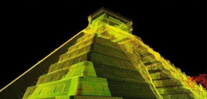
In the face of the transcendent task to preserve our cultural heritage for future generations, 3D laser scanning opens a door to document, study, understand, and monitor any element or site of our cultural world heritage. We need to measure what we treasure so local planning authorities and specialists like archeologists and conservators can make better decisions based on reliable and useful information. If our treasures are measured, we will also be able to rebuild the pieces of our heritage in case they get lost or damaged in the future.
With the Leica Geosystems laser scanning solutions, surveyors and reality capture technicians around the world are able to measure and point cloud with millimetric precision and high resolution any historic monument or building. Millions of points are converted into 3D models that allow specialists to understand how structures were built and the current conditions and threats they face.
Research institutes and nonprofits like CyArk and D.H.A.R.M.A are using Leica Geosystems laser scanning technologies to document our physical heritage to study and preserve the past.
However, the deliverables produced from the 3D laser scanning can be used beyond the purposes of preserving cultural heritage and can also help to guide the expansion of projects, engage future promoters, and increase tourism by allowing virtual public access.

Leica ScanStation P40.
Australia´s Perth Concert Hall, renowned for “having one of the finest acoustics in the southern hemisphere”, has been 3D mapped by RM Surveys to expand its possibilities of engagement with visitors and future promoters. The 3D model of one of Australia´s finest acoustic venues generated with the Leica P40 will also “help promoters to produce more magnificent concerts and performances, and help us [Perth Concert Hall] in the future development plans”.

The ALS80 LIDAR solution
Furthermore, 3D laser scanning technology has the ability to point cloud what meets and escapes the human eye. Laser scanners have the power not just to preserve but to rediscover ancient sites and cities. Using a Leica ALS80 LiDAR instrument mounted to a helicopter, hidden cities in the Angkor region in Cambodia were revealed. Likewise, UK´s Environment Agency recently accidently discovered miles of ancient roman roads while monitoring with a LiDAR scan the change in coastlines.
Whether it is 3D capturing a concert hall, a 17th century Swedish Vessel, the Taj Mahal, the Canterbury Cathedral, the Ellis Island in NY, or rediscovering an ancient city, Leica Geosystems provides the hardware and software solutions for surveyors and specialists worldwide to preserve and understand our past and present for our future generations.
To learn more about Leica Geosystems laser scanners for any task in 3D laser scanning click here.


