


Over the next decade and with the emerging metaverse, the real world will become fused with real-time digital realities created from sensors that capture the real world in 3D and build smart digital twins with stunning precision. This data, and the sensors and systems that capture it, implements automation systems in construction, manufacturing, and industrial facilities to further efficiencies, safety and security, infrastructure, and logistics. All of those sectors translate into energy consumption, food production, and even travel and leisure. And all these areas are expected to be part of what we now call Smart Digital Reality.
Smaller, smarter, more mobile
Scanning technology is moving into three main areas: compact devices for handheld operation, UAVs for scanning hard-to-reach locations, and robotics solutions for on-the-ground scanning.
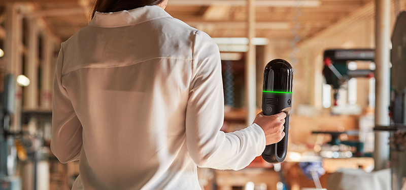
The Leica BLK2GO handheld imaging laser scanner is an example of advancements in handheld mobile reality capture technology. It’s a wireless and lightweight sensor that enables reality capture on the move, in real-time, by using Simultaneous Localization and Mapping (SLAM) technology. A bit like a torch for visualising the 3D realities of our world, the BLK2GO automatically builds 3D point clouds while it’s in motion and can scan over and under objects, up and down stairwells, and in other congested areas.
Aerial laser scanning (e.g. UAV-based) provides detailed models of uncharted areas in the form of colorized 3D point clouds and, at the same time, creates accurate digital twins of diverse and interesting areas and landscapes. It provides a new dimension to digital reality, capturing rooftops and entire buildings in only a few taps on a tablet.
Robotics are also paving the way in autonomous reality capture, physically carrying sensors and autonomous systems that captures 3D data and panoramic imagery by walking through environments.
These new developments in autonomous reality capture are simple to use, easy to deploy, and are available now. They are becoming more accessible across industries, extending the scope and use cases for the technology as it evolves.
Fusing technologies to put data to work
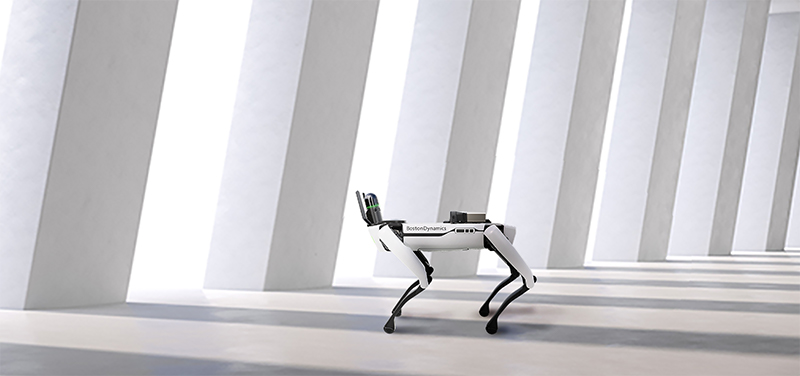
A fusion of technologies enables autonomous systems to take leaps and bounds in their capabilities. An example is the Leica BLK ARC autonomous laser scanning module which is currently compatible with Boston Dynamics Spot®, the robotic dog. Spot® is known for patrolling construction and mining environments, but the robot’s versatility will expand even further across industries with the integration of the BLK ARC.
This fusion of technology has meant robots, like Spot®, are capable of more than ever before, and these capabilities can only grow in the coming years. Through the BLK ARC, project managers have the power to put data to work by setting paths for Spot® using existing drawings or Building Information Modelling (BIM) of buildings, creating more efficient workflows while saving time and money. The BLK ARC has the ability to perform scans more frequently for construction progress documentation and can easily scan challenging areas like underground environments, difficult or mountainous terrain, and even hazardous areas such as mines, power plants, offshore facilities. The BLK ARC can even improve public safety by capturing fire damage, crime scenes, and even man-made or environmental disaster sites.
Once captured, all of this data provides powerful insights through advanced software for visualizing and analysing point clouds and 3D models. These robots, sensors, and laser scanning software work together dynamically to create intuitive reality capture workflows. Research predicts the inspection robotics market to grow by $8.23 billion by 2025, and the smaller and more agile systems like the BLK ARC will help drive a “robotic revolution.”
Reaching new heights with flying laser scanning
Sensors for airborne scanning are also becoming smaller, faster, and more agile and easy to use than traditional UAV scanning or photogrammetry setups.
These autonomous products are expanding to meet the needs of more specific projects, and to adapt to industry demands, 3D laser scanning and photogrammetry via UAVs are becoming increasingly used. There are two main reasons for this.
First, they can be programmed, which means humans aren’t required to capture and align the same data every time. Secondly, they are convenient for security and safety because they can go places that people can’t or where it is too dangerous. Flying laser scanners can be used underground, in urban environments, or anywhere without GPS because they use SLAM spatial awareness technology to navigate.
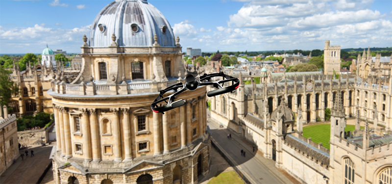
This what the Leica BLK2FLY autonomous flying laser scanner provides as a fully-integrated autonomous scanning system, and can come into its own not just with its scanning capabilities, but also with advanced obstacle avoidance. By fusing onboard sensors like LiDAR, radar, cameras, and GNSS, the BLK2FLY can scan exteriors and features that are difficult to scan from the ground, including hard to access areas like rooftops and facades.
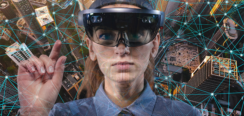
Augmented reality is augmenting
Autonomous reality capture solutions, like the BLK2FLY and BLK ARC, allow us to put Smart Digital Realities in the palms of our hands, and even allow us to see them with more clarity and information than ever before. While those cumbersome-looking Augmented Reality (AR) headsets might still be off-putting for many, the digital environments within them are becoming more commonplace on less awkward devices, including smartphones and tablets, allowing us to build real-world digital environments for our convenience.
By superimposing a digital twin of a building site in 3D, all project stakeholders become much better informed and can make decisions faster and with better information. A project manager can transport themselves from the office to the heart of the construction site digitally to manage projects in a live reality. The Smart Digital Reality they will receive exact data of what’s happening in the construction site right at that moment without the lost time and expense of travelling to and from the site. A growing combination of the available technologies and their associated applications could drive a boost in professional-standard AR both this year and during the next few years.
The opportunities with having Smart Digital Realities are virtually infinite. Settling for a digital twin isn’t enough as we move towards an autonomous future. The difference between a digital twin and a Smart Digital Reality is time. Things change over time, and Smart Digital Realities can now enable digital twins to change over time – vital for entire operations, industries and cities to understand information as it changes in the real world.
At Leica Geosystems, we start with the real world by capturing data and transferring it in real-time to a digital twin for data visualisation and analysis. This is what puts data to work and impacts the real world. As we look toward the future, this autonomous and intelligent technology will have a profound impact on the way we live, and we’re excited about what that future holds.

Pascal Strupler
Business Director
Autonomous Reality Capture
Join us at HxGN LIVE Global, Hexagon’s flagship global conference for a deep dive into digital reality solutions.