The train network in Melbourne, Australia, is getting a major revamp with several projects in progress to help tackle congestion. To improve travel around Melbourne, the Victorian Government is removing 50 dangerous and congested rail level crossings, which will deliver significant safety improvements for drivers and pedestrians.
In addition, the Metro Tunnel project will add five new underground stations and 65 next-generation high capacity trains for the metropolitan network – freeing up more trains across the Melbourne rail network. This also means that 55 kilometres of next-generation, high-capacity signalling will be installed, allowing the trains to safely run closer together and more often. This will be the first roll-out of high capacity signalling on an existing network anywhere in Australia.
To prepare for the busy piece of Melbourne’s railway infrastructure, topographical surveys were needed. The Metro Trains Melbourne & Laing O’Rourke GWAF project turned to Heading and Associates, a professional surveying and project management firm specialising in survey, construction supervision, property and environmental survey, and design applications, to perform several surveys.
Site limits and challenges
As part of the Level Crossings Removal Project, the team at Heading and Associates was tasked to map out a rail line covering 26 km – a rail line where existing survey-grade data was not available.
To deliver the level of detail needed using traditional survey work, the project team would need to work at night with terrestrial laser scanners. The project timelines and budget did not allow for this – the only solution was to use a mobile mapping system mounted on a hi-rail to capture the data safely and efficiently.
Going mobile
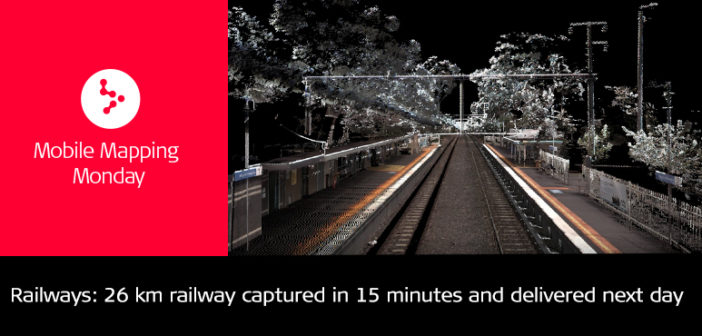
Using the Leica Pegasus: Two mobile mapping solution, Heading and Associates conducted the surveys for the 26-km rail line in just 15 minutes and delivered the data to the client next day. To put this into perspective, using traditional methods the same project would have taken an additional two months in the field to complete with the same amount of detail.

By mounting Pegasus: Two to the hi-rail, the project team could eliminate danger zones and significant health and safety risks, capture high-level detail and provide the client additional data such as wire locations and overhead power lines without disruption to the network. This level of detail could not have been captured in the same amount of time using traditional survey practices.
Using the mobile mapping process and Leica Geosystems’ technology, Heading and Associates could capture the rail length with a scan speed of 1 million points per second, maintain survey grade accuracy of less than 2 centimetres and deliver the project on time, on budget and with safety at the highest priority.
A smarter way
Pegasus:Two allows data to be extracted from the point cloud for a range of applications including:
- Centreline alignment
- Measuring road edges and line markings
- Digital terrain models of road surfaces and surrounding corridors
- Asset identification and location
- Clearances to nearby structures
Heading and Associates could use the data for dilapidation surveys to capture the current condition and safeguard their client from any additional costs. Because point clouds provide a comprehensive view, immediately required data can be extracted from the cloud to meet instant customer needs, without needing to return to the site to collect data.
Other advantages of using the Pegasus: Two include:
- As built surveys to confirm newly constructed rail works meet design specifications
- An error-free data baseline survey to allow monitor any changes to the design in the future
- Current road condition, such as cracks, potholes and, edge of bitumen for maintenance inspection purposes
- Accurately establishing rail clearances to overhead wires and station platforms
Moving forward
For Heading and Associates, the survey-grade accurate data available from Pegasus:Two creates opportunities to undertake additional and larger projects since an area only needs to be scanned once to generate multiple assets.
“A mobile mapping solution opens opportunities for rail specific projects as it removes the limitations of stopping trains, interrupting the service network, and the need to survey at night,” concluded Heading.
Heading and Associates are looking to apply mobile mapping technology to secure projects for the regional rail networks consisting of thousands of kilometres.


