


This three-part series explores how Hexagon’s wide range of products and services contribute to a more sustainable economy, safer workplaces, and a greener planet.
Hexagon’s commitment to a sustainable future
As the significance of Environmental, Social, and Governance (ESG) criteria continues to grow, it is becoming clear that the future of business performance lies in the balance of profit, planet and people. Forward-thinking organisations like Hexagon are rising to the challenge, holding themselves accountable for their impact on the environment and society. Hexagon seeks to have a positive impact through its operations and solutions. Leveraging our innovation potential, we employ cutting-edge technology to drive the shift toward a more sustainable future.
We are also committed to doing more than stating our values – we want to show you how these values manifest themselves, from the long-lasting products we create, to technologies that enhance safety and protect people and the environment, to solutions that help advance the transition to a low-carbon future. This series demonstrates this commitment in action and provides resources for learning more.
Environmental sustainability
Hexagon technology helps advance the transition to a low-carbon future. Our solutions support the development of environmentally friendly mobility, reduce energy consumption and waste, optimise renewable energy production and help protect blue carbon ecosystems.
Green transportation
Geospatial technologies and surveyors play a crucial role in developing infrastructure and green transportation projects to make cities more inclusive and resilient. Utilising advanced surveying tools, surveyors can accurately and efficiently capture data essential for modernising infrastructure. Geospatial data is key for sustainability projects including making cities safer for cyclists, redesigning bus stops to accommodate longer buses or improve accessibility for individuals with disabilities. The use of geospatial technologies and the continuous innovation in surveying equipment not only streamlines the urban development process but also contributes to creating sustainable, equitable, and resilient cities with improved infrastructure and green transportation systems.
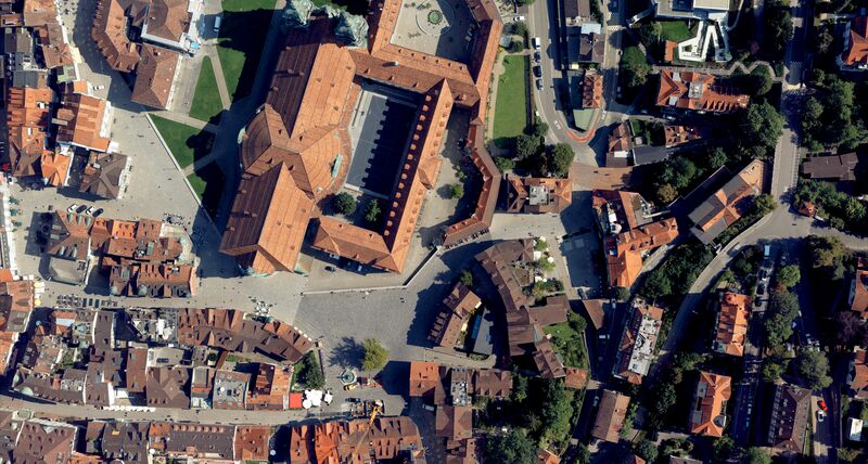
Sustainable urban development
Parks and green spaces are an integral part of vibrant sustainable cities. Digital 3D visualisations help identify suitable areas for green belts and fresh air corridors in St. Gallen with the goal of making the city more sustainable and livable. Hexagon’s Geosystems division supported the project “Green Gallus Valley.” The Leica CityMapper-2 was flown over the city to capture highly accurate aerial and laser data. That data was then used as a hybrid model in Cyclone 3DR to create a digital twin and a video that simulates the city’s greening.
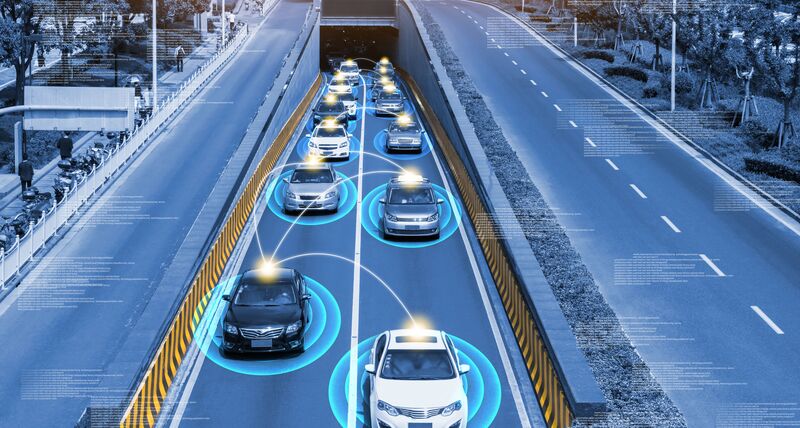
Autonomous mobility
Autonomous mobility promises vast gains in efficiency and significant reductions in carbon emissions. However, safety concerns remain a significant hurdle for the widespread adoption of driverless vehicles. Regulatory bodies have prioritised safety as the top consideration in the development and deployment of driverless vehicles.
Testing possible scenarios at scale to enable safe and successful autonomous mobility is not feasible in the physical world — but it is in the digital world. Hexagon’s Smart Digital Reality™ — including advanced simulation tools, assured positioning solutions, high-definition mapping and sensor fusion capabilities — allows for the virtual testing of millions of autonomous mobility applications across air, land and marine applications.
Positioning services
HxGN SmartNet is the world’s largest Global Navigation Satellite System (GNSS) correction service, providing data from over 5,300 reference stations worldwide. The use of GNSS technology has numerous benefits for sustainability, including improving the efficiency of transportation and reducing the environmental impact of human activities.
Sustainable harvesting
Mapping shorelines with Hexagon’s airborne solutions also allows coastal managers and communities to plan for a changing climate. Researchers also use Hexagon’s bathymetric data to detect and analyse underwater vegetation to measure ocean health. In one region where locals use rockweed as fertiliser, the same method allows researchers to develop sustainable harvesting methods that avoid depleting more rockweed than regrows.
Sustainable land
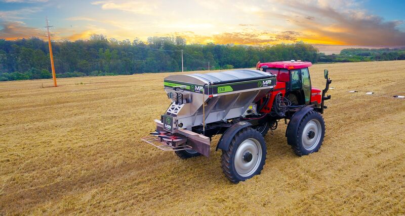
Precision agriculture is an emerging field that uses GNSS technology to optimise crop yields and reduce the use of fertilisers and pesticides. A Reference Station Network (RSN) can provide the precise positioning data needed to support these applications, which can have a significant impact on the sustainability of agriculture.
Precision agriculture uses technology to optimise crop production by collecting data on soil, weather and crop growth, and using the data to make precise decisions about planting, fertilising, irrigating and harvesting crops. This technique helps increase yield and farm more sustainably by reducing waste, improving efficiency, conserving water, minimising soil erosion and reducing chemical usage.
Sustainable land development requires accurate and detailed maps. Our GPS antennas offer precise positioning data for Geographic Information Systems (GIS), enabling land management experts to access advanced land intelligence and make informed decisions. For example, precise measurements from premier GPS/GNSS antennas can help create GIS maps of soil quality that accurately capture the reality of the under-earth conditions.
Material reduction
Machine control solutions contribute to sustainable construction practices. Guiding operators to move the exact needed amounts of material to the right place helps reduce material needs, increase productivity and deliver planned designs accurately.
For example, machine control technology in road construction helps ensure that only the necessary amount of pavement is milled and replaced with new hot mix of asphalt or concrete material. 3D technology can also play a key role in applying only the designed amount of new pavement required for a project. Even a slight reduction can have a remarkable impact, resulting in substantially reduced carbon dioxide emissions, improved quality and time savings. The high-quality results directly impact the longevity of the infrastructure and thus contribute to long-term sustainability.
Reducing energy consumption
Hexagon’s reality capture solutions help create digital twins of buildings and facilities, including underlying networks and infrastructure. Digital twins enable smart 3D facility management by equipping facility managers and operators with the tools to optimise performance and reduce energy consumption and enable remote asset and facility maintenance to avoid unnecessary travel. Accurate location-based asset management and real-time data retrieved from sensors and smart IoT devices help them get more insights, anticipate risks and visualise future changes with unprecedented accuracy.
Waste reduction and prefabrication
Prefabrication offsite increases efficiency because you can construct the elements in a controlled environment. However, being produced offsite, the dimensions need to be perfect so they fit once they are delivered to the site! Precise measurement technologies are needed to ensure building progress matches design, and that deviations from design are identified early to minimise rework and waste.
Circular economy
Construction and Demolition Waste (CDW) is a significant waste stream globally. 3D laser scanning technology offers a promising solution to this problem. By scanning buildings before they are demolished, contractors can estimate the available materials and plan their demolition and recycling strategies more efficiently.
With 3D laser scanning, a digital twin of the demolition object can be captured with remarkable speed, enabling the visualisation, extraction, analysis and sharing of valuable information through user-friendly software solutions. With just a few clicks, contractors can calculate the exact volume of an object, allowing for more precise and accurate estimations of available materials.
Offshore wind power
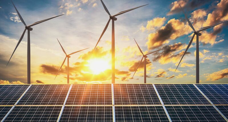
Renewables, especially solar and wind energy, are a crucial puzzle piece when it comes to reducing greenhouse gas emissions, cutting energy costs and becoming energy-independent.
Offshore wind farms are an increasingly popular method of generating renewable energy. They consist of large wind turbines that are anchored to the seabed and connected to the electrical grid, allowing for the production and distribution of clean energy. However, constructing and maintaining these wind farms can be challenging and expensive due to the harsh marine environment and logistical complexities. Leica Geosystems’ accurate total stations allow for the precise and optimal positioning of the wind turbines, ensuring efficient energy generation and long-term viability of the wind farm. Moreover, the technology eliminates the need for workers to access difficult-to-reach areas, reducing the risk of accidents and injuries.
Solar potential
Optimising solar technology is crucial to making it a more viable and cost-effective source of renewable energy. Hexagon technology is assisting in this process.
One innovative solution is Leica HxMap, a unified high-performance multi-sensor workflow platform by Leica Geosystems. This platform allows users to combine 3D city models with environmental data, enabling them to predict the solar potential of a given area with high accuracy.
Leica Geosystems’ robotic total stations are versatile instruments that can be used to align photovoltaic systems accurately. This precision-based technology further streamlines the installation and optimisation process for solar energy systems. By correctly aligning the panels, you can achieve the orientation to the sun that optimises energy production.
Another valuable Hexagon technology is the Leica DISTO™ S910, which boasts point-to-point measuring capability. Measuring the size of the roof remotely with the DISTO allows planners to calculate the area of solar panels that can be installed on the roof. Remote measurement is also safer, as it eliminates the need to climb on the roof for measuring.
R-evolution:
Hexagon’s business venture R-evolution invests in green-tech projects where Hexagon’s technology can be applied. It is business-driven and shows that helping the world transition to a new greener economy is an opportunity. Sustainable, profit-driven projects can propel society toward that vision.
Protecting blue carbon ecosystems
Seagrass is a vital part of the coastal ecosystem, providing a habitat and food for various marine life while also serving as a blue-carbon ecosystem that can store ten to fifteen times as much carbon as their terrestrial counterparts. Mapping is a crucial first step in protecting these important ecosystems. In The Bahamas, Hexagon’s sustainable business venture R-evolution and Beneath The Waves are working together to explore and scale the potential of seagrass meadows as a nature-based carbon sink.
R-evolution’s deployment of survey aircraft geared with one of Hexagon’s airborne bathymetric LiDAR solutions, the Leica Chiroptera 4X, enables a cost-effective, rapid survey of large areas. Compared to current satellite- and vessel-based mapping solutions, airborne bathymetry provides more detailed maps at a faster pace and across larger areas — accurately mapping thousands of square kilometres of seabed habitats at up to 30 meters water depth in just a few days.
In 2021, R-evolution launched our photovoltaic (PV) power production initiative. The solar park project kicked off with the acquisition of a 40-hectare site — equivalent to 60 football fields — in the south of Spain. The site hosts a 16.44 MWp photovoltaic solar park, which contains approximately 40,000 solar panels that convert the sun’s energy into clean electricity and connects to the grid.
The solar park includes bifacial (double-sided) panels that are mounted on horizontal axis trackers. The panels enable energy absorption from both sides and automatically tracks the sun to increase efficiency and output.
R-evolution is expanding the park’s efficiency by putting data to work using Hexagon’s hardware and software monitoring solutions, including visualisation platforms and sensors. The technologies create a Smart Digital Reality of the entire solar park that is remotely and autonomously monitored to detect solar panel anomalies, improve maintenance, aid inspections and more.
Conclusion
Hexagon’s vision is to help save the planet by developing technology that supports sustainability goals. Our sustainability strategy aims to drive the shift towards a more sustainable future while also providing a financial return. Hexagon leverages cutting-edge technology to enable sustainable development. We address customers’ urgent challenges while also promoting the smarter use of Earth’s resources. Hexagon is committed to upholding high standards of sustainability in its internal operations and activities and seeks to improve ESG aspects throughout the supply chain.
A strong commitment to sustainability not only generates financial incentives, such as reduced risk exposure and cost savings, but also nonfinancial benefits, such as improved safety and improved use of natural resources. By upholding ESG standards in all aspects of our operations, we bolster our resilience as a business and benefit all stakeholders in the long run.