


For 20 years we have set the standard in 3D laser scanning by continuously delivering products designed to perform with consistency and reliability. Since the year 2000, our journey began with the well-known and trusted Cyrax brand of laser scanners and ever since, we have continued to raise the bar with ground-breaking innovations.
Our high-performance 3D laser scanners provide industry-leading millimetre accuracy for the highest level of confidence and reliability in the field and they provide the utmost versatility. Add this to powerful software, experienced service and support and efficient workflows, and you have a complete laser scanning solution that increases safety, facilitates quick project turnarounds, saves money and substantially reduces the likelihood of human errors.
In this blog, we have highlighted the ‘top ten most-viewed case studies over the years’ which might support you to recognise new business opportunities or refresh your workflows with the latest laser scanning technology. Click any of the links below to read the full stories:
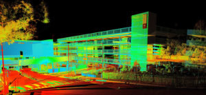
When an international retail group approached the Australian surveying firm, Project Surveyors, about creating a survey-accurate architectural and structural Revit Building Information Modelling (BIM) model for the country’s second-largest shopping centre, the firm was excited to participate. When the deadline was set for only 90 days later, Project Surveyors knew while future centre customers may shop ‘till they dropped, the firm’s seven qualified laser scanning surveyors would be doing the same with 3D laser scanning.
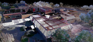 Frank Lloyd Wright’s Taliesin West was always a place of innovation and exploration, where the architect returned every fall to test the limits of architecture, design, and building. To continue this legacy, the Frank Lloyd Wright Foundation partnered with Leica Geosystems and Multivista to make Taliesin West a universal and accessible experience, as well as give a new depth of understanding into this unique and ever-evolving site. Using the Leica BLK360 and the Matterport Pro2 3D Camera, Multivista conducted a series of 3D digital imaging laser scans of Wright’s winter camp, generating a highly-accurate, fully-detailed, 3D point cloud of the property, along with a high-definition virtual reality model.
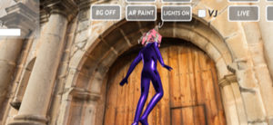 A collective of augmented reality (AR), virtual reality (VR) and mixed reality (MR) visionaries, programmers and render artists are on a mission to create a digital replicate world to showcase the beauty and history of Central America, starting with the entire country of Guatemala. The Unreality Journeys team and G2 Foundation are pushing the boundaries of laser scanning, AR and VR technology in a not-for-profit cultural heritage project. In this ground-breaking cultural project, Unreality Journeys captures ancient structures created by indigenous communities and their impact of modern society.
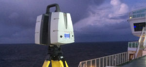 Time is money, especially in the shipping and maritime industries. Enhancing productivity while repairing and retrofitting large vessels is crucial as stopping commercial operations is a total financial loss for ship-owners. 3D modelling and BIM generated with laser scanning can provide a detailed digital blueprint of a vessel, increasing productivity during navigation, easing retrofit and improving maintenance. To minimise time spent in the dock, NautiSCAN3D, a company specialised in 3D modelling and measurements, surveyed a 288-metre-long passenger ship. This survey helped architects to check for production clashes and to plan retrofit of a scrubber system.
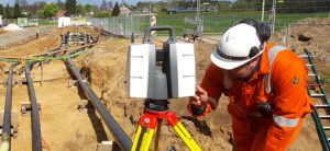 For undisturbed and safe gas delivery, it is important that the network is always in excellent condition. Gasunie, a European operator that provides the transport of natural and green gas in the Netherlands and the northern part of Germany, performs management and maintenance work to the gas transportation networks. When replacing and maintaining pipes, Gasunie combines multiple Leica Geosystems solutions that make laser scanning data available directly from the field to the customer and subcontractors. Before integrating Leica Geosystems solutions, the time to deliver the as-built situation took quite long – now, a precise as-built model is ready within 24 hours.
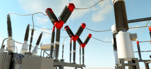 BIM has changed the way professionals in the architecture, engineering and construction industries improve coordination and reduce rework thanks to 3D intelligent models that are accurate, accessible and actionable. Sertogal SL used Leica Geosystems’ laser scanning solutions to create a BIM model that will guide the remodelling and expansion of the electrical substation of Mera in the Spanish province of Ourense.
 The digital documentation of heritage sites is a fundamental step to record the actual condition of an archaeological monument and facilitate the decision-making of experts for a comprehensive conservation plan. With the help of the Leica BLK360 imaging laser scanner and Leica Cyclone 3D point cloud processing software, a team of Mexican archaeologists was able to carry out a precise survey of all underground chambers, exterior surroundings and detailed carvings and paintings on the tomb’s walls of Egypt’s few female pharaohs, Queen Hatshepsut.
The digitalisation and restoration of the extensive tomb not only helped preserve the site for future generations but shed light on the queen’s reign.
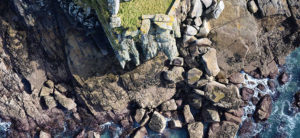 In 2003, visionary Ben Kacyra founded CyArk with his idea to create a free and digital archive of cultural heritage sites and architecture to preserve them from natural or human destruction. With its knowledge and expertise in 3D laser-scanning to create high-resolution point clouds, CyArk took surveying and mapping of cultural heritage sites to another level by preserving the entire island of St Michaels Mount digitally for further generations.
![]() Heliopolis, the City of the Sun, was inscribed in 1984 as an UNESCO World Heritage site. This ancient Roman city, today called Baalbek, in the Beqaa Valley in Lebanon, has a complex of temples that is an outstanding example of ancient Roman architecture. The Temple of Bacchus, in the sanctuary complex of Baalbek, is among the largest, best preserved and most impressive of its kind. To digitally document and preserve the majesty of the Temple of Bacchus for further generations, master students of the Surveying Engineering Department at the Lebanese International University captured the temple in 3D.
Heliopolis, the City of the Sun, was inscribed in 1984 as an UNESCO World Heritage site. This ancient Roman city, today called Baalbek, in the Beqaa Valley in Lebanon, has a complex of temples that is an outstanding example of ancient Roman architecture. The Temple of Bacchus, in the sanctuary complex of Baalbek, is among the largest, best preserved and most impressive of its kind. To digitally document and preserve the majesty of the Temple of Bacchus for further generations, master students of the Surveying Engineering Department at the Lebanese International University captured the temple in 3D.
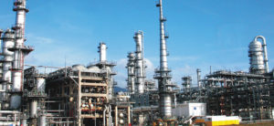 A coal-fired power plant in Wyoming was producing 2,110 megawatts of electricity per hour from four 500-foot-high generating units that serve more than a million people throughout the region. Because of its importance to the community, the plant could not afford the slightest setback in the installation of its new emission control system, which was required to comply with EPA regulations. Laser scanning was new to the engineering firm, so Gidcumb and his team needed reassurance that the data collected would be accurate and provide the necessary information.
Are you interested to learn more about laser scanning applications? Click here for a complete overview of all case studies.