


Surveyors prepare, collect, process, and share great amounts of data. Having instant data access and transfer allows faster decision making. Being aware of the current state of every project and report on individual steps and results is valuable.
Having the right office software simplifies workflows and increases transparency and efficiency in every surveying company.
In this blog, we explore facts you need to consider when selecting surveying office software and how Leica Infinity surveying office software is supporting surveyors in every step – be it visualising, preparing, collecting, processing, confirming, reporting and/or sharing data.
-
Have surveying office software that allows you to combine data
The ability to process data together simplifies your workflows. Whether you use TPS, GNSS or UAV in your survey, you need to be able to derive high-quality results. Direct access to all raw data lets you combine and cross-check against processed data.
With Infinity, surveying teams can:
- Import, view, analyse and combine data from TPS, GNSS, level, MultiStation and UAV.
- View the 3D data sets and process together with other survey results. Derive point clouds, digital surface models and orthophotos.
- Find instrument info and data, which makes it easier to interpret and complete project work.
- Use images from total stations and GNSS to measure points, saving time from site revisits, reacting to changing needs and improving documentation as no detail is missed.
Customer story

To measure the impacts on climate change on the arctic tundra in Canada, Marsh Lab TVC analysed the actual snow and ground surface elevation. On the ground, they used a Leica Geosystems GNSS system to measure ground control points for UAV survey.
In the field, the team used Leica Captivate software and two Leica GS10 GNSS receivers to collect the data, and the office work was done using Infinity. They used Infinity to process and filter the collected data. The points collected with GNSS were used as ground control points for the UAV-captured images to ensure the highest accuracy and reliability.
“Our fieldwork relies heavily on obtaining high accuracy spatial datasets and our Leica Geosystems GNSS system makes all of this work possible,” said Branden Walker, Research Associate at Wilfrid Laurier University.
Read how GNSS and software solutions are used to measure the impacts of a changing climate.
-
Have surveying office software that helps you to visualise, prepare and report on data
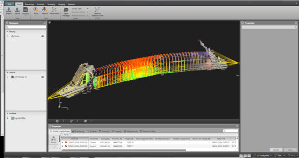
A powerful surveying office software provides you with the tools to process complex networks of measurement data with absolute precision in an intuitive 3D environment, including documentation, reporting for full data traceability ensuring data quality. Bringing in CAD design data can better visualise the scope and scale of projects, helping to prepare field measurement and staking tasks effectively. It allows you to visualise imported field data for quality control, processing and sending to CAD. Surveyors use this to verify if fieldwork was done to the expectations (quality, tolerance checks, etc.).
With Infinity, surveying teams can:
- Easily bring in, visualise and prepare data for fieldwork from design (CAD/BIM/GIS).
- Double check the work in the field and fix any mistakes with complete traceability from field to office.
- Generate reports, document and QC your projects for complete traceability.
- Compare surfaces from different surveys and highlight changes between them to report on changes in volume, movement, etc.
 Customer story
The ability to import and view the raw survey and scan data so easily quickly convinced WestLAND engineers to rely on Infinity. WestLAND was also impressed by the ease of doing control traverse network adjustments using conventional survey points. With this information, they were able to adjust the point cloud data. The team can easily export data into multiple file formats and import directly into MicroStation, AutoCAD Civil 3D, and/or Revit, depending on the application and required deliverables.
-
Have surveying office software that is connected
Finally and most importantly, ensure your teams are able to connect to surveying ecosystem directly from the software. They need to be able to connect with teams end equipment in the field, connect to data services and connect to other software for further analysis and usage of the data. Especially cloud-based integrated services help to manage and share survey data between users in the office or in the field. On big construction sites, data can be shared between survey teams and machine control units.
With Infinity, surveying teams can:
- Connect to data services by Leica Geosystems, Hexagon and others, such as Bentley ProjectWise, Autodesk BIM360, BricSYS 24/7 and Esri ArcGIS. Use HxGN Content Program imagery as base maps in a project.
- Download GNSS reference data direct from HxGN SmartNet to support control survey processing
- Move and share data directly with Leica Exchange and Leica ConX, sending data directly to users or to machines.
- Import data from third parties and use industry formats for design, including IFC alignments, InfraGML.
 Customer story
Portcoast, Vietnam’s leading port and coastal survey consultants work in projects across Southeast Asia, Pakistan and U.A.E. The company is particularly conscious of the importance of fast data transfer in tropical countries. The rapidly changing weather conditions demand fast data transfer between field and office teams to verify data and minimise lost time waiting. After collecting the data through cloud from the geodetic equipment, Portcoast uses Leica Infinity off-site to process data.
“The high-speed and high-level accuracy of capturing field data helped to avoid delays in office post-processing as the software helped us to check the points every time we needed to. With Infinity and ConX it is easy to transfer data between the field and the office within 1 min,” said Dr. Hoang Hiep.
Whether you are working on an AEC, cadastre or high-end survey, BIM, construction survey or asset collection projects, Leica Infinity surveying office software simplifies your workflows and helps you deliver high-quality deliverables and give added value to your clients.
Read how surveying office software can simplify your workflow or watch the webinar “10 key features of Leica Infinity survey software.”
Discover the benefits of Infinity.