


Looking out from the window, my son was describing the new Skyline of Milano. He called me impressed with how it’s changing rapidly in the last years and explained a skyscraper was completed and construction for a new one had started. He described how the buildings are tall and have different modern shapes; one looking like is twisting on itself and another drawing a curve in the sky.
I explained to him how the fast development of measuring and positioning instruments are helping to build this infrastructure in a fast and secure way.
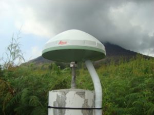
Structural Monitoring with GNSS
Structural monitoring with total stations is more common and better known than monitoring with other spatial sensors, and for a good reason—total stations are a great choice in most situations, given their ability to monitor up to hundreds of points from a single setup, in real time and with high accuracy.
However, there are many challenging monitoring projects -like the skyscrapers in Milan- that require the unique capabilities of GNSS to be used alone or in combination with a total station or with other geotechnical sensor.
GNSS monitoring is sometimes the only choice because you can use it in all-weather conditions, don’t require long lines of sight to ground-based control, and GNSS receivers update 3D position continuously without needing to reference other earthbound points that can be not visible in some circumstances.
Let’s look at some examples where GNSS is used for monitoring:
- In a landslide monitoring situation, where a total station might have to be placed in a location that is itself unstable, a prism-mounted receiver can be positioned nearby and included in the total station’s monitoring routine. This provides an excellent check on the absolute position of the occupied point and the overall network.
Read how GNSS real-time monitoring supported landslide risk management in British Columbia, Canada.
- In the construction of tall buildings, it is very important to build vertically accurately. If the verticality of construction is wrong, the building cannot resist a vertical and lateral load safely. Hence, the building cannot stand vertically and maintain a healthy condition. GNSS monitoring systems are used to obtain precise and reliable coordinates during the entire construction process that are not influenced by the movement of the building.
Read how a tailor-made GNSS solution obtained precise and reliable coordinates during the construction process of London’s second tallest skyscraper.
Depending on what you need to monitor, you can use a different kind of GNSS processing and software/service to get the desired accuracy and information from GNSS observations. The main difference relies on the type of processing that you will apply to the observation.
Leica Geosystems developed a procedure, using GNSS observations combined with tiltmeters (precision inclination sensors), to obtain reliable coordinated points at the top of the formwork of the ascending skyscraper. Those coordinated points, or Active Control Points (ACP), are sighted by Leica Geosystems robotic total stations to setup its coordinates and orientation.

Super-tall Building Plumb in New York City using Leica Geosystems Vertical Alignment System
Real Time Kinematic for Monitoring Applications
Real Time Kinematic (RTK) is a relative technique that will give you a 3D position of the monitoring point and at a chosen rate. Reference stations in a stable area are also required to compute the position of the points.
Real time monitoring at high speed is also a specialty of RTK; for example, the sway of a bridge at mid-span may be tracked at positional movements up to speeds of 50 Hz – so accurately that we can tell when a large truck is crossing the bridge and which direction it is headed.
Post Processing for Monitoring Applications
 Post Processing is a well-known GNSS Processing technique that uses more observation and gives a 3D position of a monitoring point. For this highly accurate technique, a reference station in a stable position is also always required.
GNSS monitoring may be at least as common as total station monitoring for assets like dams, bridges, landslide areas, and open-pit mines, where rapid catastrophic failure is not expected. Still, knowledge of relatively small movement over months can be valuable.
Offshore drilling platforms are a great example; they rarely fail, but monitoring movement compared to the seabed can be incredibly useful for operation and safety. Without stable backsights available off-platform, total stations are not of much use. Since real time feedback on position is not so critical on projects like this, adequate information can usually be provided with just a few receivers. In the case of an offshore platform, the subsidence can require a very long baseline with a stable reference station.
In such cases, commercial software is maybe not enough to process quite long baselines. In this case, the solution is to use Leica CrossCheck monitoring service and benefit from our support team in Heerbrugg, who will prepare the configuration of the processing using scientific software and state-of-the-art models. Daily results will be available for the user on a dedicated web platform where they can also be downloaded and integrated with other software for further analysis. The main benefit of this solution is that no expertise or infrastructure is required.
Autonomous Solution for Monitoring Applications
Leica Geosystems has implemented the world’s first autonomous GNSS monitoring solution onboard a stand-alone receiver called Leica VADASE developed in partnership with University of Rome, La Sapienza. The new Leica Velocity and Displacement Autonomous Solution Engine, or VADASE, provides an in-depth look into fast movements of various natural activities and man-made structures. Delivering actionable information in real time, this autonomous solution streams velocity and displacement data at a high frequency.
Building an Effective Monitoring System
The effectiveness of a GNSS monitoring system is dependent on the quality of the actual receivers; the overall design of the monitoring routines and administrating software is at least as important. Ideal applications have good routines for both real time and post-processed solutions; publish alerts automatically via email, web, and texting; and include data from available RTK networks and/or high-quality reference stations. Leica Geosystems’ GNSS Spider software is an example of a system that offers these capabilities.
In short, if structural monitoring is part of your firm’s business plan, don’t assume total station monitoring is the way to go. In many cases, monitoring networks that include, or are wholly composed of, GNSS receivers are the most appropriate and most cost-effective solution.
Click here to learn how to get started with monitoring.

By Francesco Matonti, Senior Product Engineer at Leica Geosystems part of Hexagon