


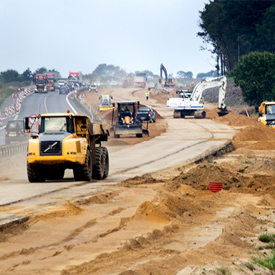
Reality capture can be used to monitor progress in all sorts of heavy construction projects, from buildings to tunnels, to roads and rail. Here we look at how you can take data captured on site by, for example, aerial survey equipment such as an Unmanned Aerial Vehicle (UAV), and process it using Leica Cyclone 3DR software, to create multiple types of report to keep projects on track. We also look at how laser measurements and mobile mapping feed into machine control, a key part of a digitised construction site that’s making heavy construction work faster, safer and on budget.
Accurate data means better reporting
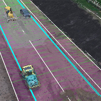
Cyclone 3DR has been developed to process data captured on construction sites. It features tailored tools for surveying, construction and inspection, which can be used to create simple but detailed reports. Cyclone 3DR lets you overlay information from many different sources, so for example, you might import a Google Streetview image, a CAD file and a dataset from a UAV or other mobile mapping system. You can then merge data from the CAD plan onto the point cloud to see where the real view and the representation differ.
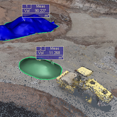
It’s a really versatile software solution. For example, you can use it to analyse 3D aerial images of a site to measure the volume of stockpiles in seconds – something that’s time-consuming to do accurately on the ground. You can in fact create stockpile reports for every pile, input the different material types and get the specific volumes for each one. Or you can use it to create 2D representations of sections of road to ensure that the layers can be constructed as planned. Or create a heatmap of a floor of a building to see what is in or out of tolerance and needs to be checked by an expert.
Integrating another data source: machine control
You can also get report data from a machine control system – part of a digitised construction site. Simply defined, machine control is a system that calculates the position of the tool on a piece of machinery – like the bucket of an excavator or the blade of a bulldozer – and via a display, lets the machine operator know exactly what’s going on. It tells you how much earth has been taken out and if you have met the depth needed for your road, for example. A machine control system requires some instruments to position itself, this can be via a total station or laser scanning solution and sensors that transfer the position to the contact point of the tool.
It’s possible to get some simple data from the machine control system to use in reporting, in the form of measure points. For example, if you were digging a foundation and hit bad ground, meaning you needed to dig down further than planned, the operator could measure the depth of the dig to confirm how far they differed from the design. By pressing the measure point button, the system simply creates a CSV file which populates with those points. And this can be exported, by a USB stick or through the use of Leica ConX, a cloud-based platform for sharing data, and added to your Cyclone 3DR process.
The future of machine control
Machine control has many advantages in heavy construction beyond data capture. It lets machine operators work more efficiently because they have better access to information on a device inside their cab. Site safety is increased because people need to spend less time near machinery checking work. If you have data on the location of underground surfaces you can upload this to the machine control system so that it may be used as an avoidance zone, so the risk of damaging utilities is greatly reduced too.
A more advanced version of machine control is automation and the trend in the industry is for guidance systems to become more and more automated. Machine automation does the same calculations for position but has an added interface that takes some of the work out of the operator’s hands. Through either the use of hydraulics or by connecting to systems on the machine, machine automation can position the machine itself and make it meet the desired value, for example, digging to the correct depth. The excavator system especially has seen a lot of developments which will help construction teams improve their efficient use of machinery and resources. Among other benefits, this means less material waste and less fuel consumption, both factors in controlling costs and managing environmental targets.
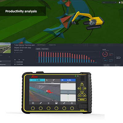
Leica Geosystems’ solution for heavy construction applications offers a unified hardware platform with common software interface across our machine control portfolio. Interchangeable between several heavy construction machines, the Leica MCP80 control unit integrates into the common software platform, Leica MC1, while Leica ConX, the cloud-based collaboration platform, rounds off Leica Geosystems’ goal to achieve a digitised construction site.
For the greatest benefits of machine control we recommend that the data used comes from an up-to-date capture of the real site, rather than from plans made in the office. Getting site data is easy using our Reality Capture solutions, including terrestrial or mobile laser scanning. And updating machine consoles with current conditions can be done via ConX or by USB. When a machine and machine operator are working with the best possible information – information grounded in reality – the best results will follow.