


Ultimate solutions for fire and explosion investigation and scene safety monitoring
After a fire or explosion, significant financial or criminal liability decisions depend on the work of the investigators who are charged with presenting a hypothesis about what happened and supporting it with solid evidence. However, the incident investigators usually arrive at a very challenging scene: firefighters or emergency response crews may still be hard at work, the light may be fading or the weather turning and if the objects and materials involved aren’t hazardous, they are certainly fragile.
A complex mix of features and debris is scattered around or collapsed on top of each other. So, working under time pressure, investigators can’t afford to commit to a single hypothesis yet. They need to capture the evidence comprehensively and in a way that will allow different hypotheses to be explored and confirmed or refuted as the case proceeds.
Therefore, the investigation should follow standardised procedures and the documentation should be done using best-in-class equipment. While identifying, collecting, and preserving physical evidence, it is vital that accurate measurements are made and that the chain of custody is rigorously documented.
At the same time, investigators need ways to address the various scene challenges. For example, how do you get clean data without interrupting the work of the fire crew or emergency personnel? Or how can you be sure that people won’t be hurt when working to investigate or clear potentially damaged structures?
At Leica Geosystems, we offer a range of laser scanning and measuring solutions for fire and explosion investigation and automated structural safety monitoring. To meet different requirements, budgets, and levels of sophistication we have different 3D laser scanning solutions for scene documentation or a range of Total Stations for monitoring purposes.
Your needs, our portfolio of proven solutions:
- ULTIMATE 3D DOCUMENTATION*
Fast, agile, and precise fire scene documentation and forensic mapping for investigation and court-ready deliverables.
Detailed information below.
RTC360 3D laser scanner > Read more - SINGLE-BUTTON 3D SCANNING WITH THERMAL IMAGING**
One-button indoor fire scene reality capture in 360° with full-colour panoramic images and thermal imaging.
Detailed information below.
BLK360 Imaging laser scanner + cyclone software > Read more - SCENE SAFETY MONITORING***
Structural monitoring for automated safety and rescue operations on a fire or explosion scene.
Detailed information below.
Total Stations > Read more
*ULTIMATE 3D DOCUMENTATION WITH THE RTC360 LASER SCANNER
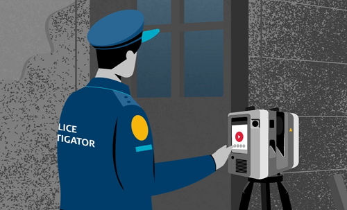
The ultimate solution for large scenes and difficult conditions is the 3D high-performance RTC360 laser scanner combined with Leica Cyclone FIELD 360 and office software for an effortless and seamless workflow. With this toolkit, you can easily capture, in real-time, a 3D virtual representation of the fire or explosion scene that users can later explore. This kind of documentation is known as a Forensic Digital Twin, and it allows for more immersive investigations and more decisive court processes.
The RTC360 laser scanner allows you to capture high-quality 3D scans at a rate of up to 2 million points per second and enrich them with High-Dynamic Range (HDR) imagery. An entire point cloud can thus be registered in less than 2 minutes. Furthermore, the system can automatically register the scanner’s move to the next position using the in-built Visual Inertial System (VIS) and thus pre-register scans in the field.
In the past, the investigator and the fire or the emergency response crew could get in each other’s way. Now thanks to the speed and agility of the RTC360 you can work faster. And a double scan feature automatically removes moving people from point clouds, ensuring that you never waste a minute waiting for someone to stand clear.
After adding additional tags and comments in the field, you can directly publish data from Cyclone FIELD 360 to the Leica TruView Cloud to share it with other team members or proceed seamlessly to Cyclone REGISTER 360 to create the immersive Forensic Digital Twin.
By the way, forensic mapping software such as Leica Map360 can integrate collected scan data directly with for example CCTV footage, images, and other relevant documents into models for analysis and hypothesis.
**SINGLE-BUTTON 3D SCANNING WITH THE BLK360 IMAGING LASER SCANNER
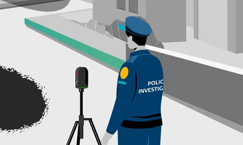
The easiest way to step into the exciting world of 3D scanning is with the BLK360 imaging laser scanner. Anyone who can operate a tablet app can now capture the world around them with high resolution full-colour panoramic thermal and HDR images overlaid on a high-accuracy 3D point cloud. Not only is it the smallest and lightest imaging laser scanner of its kind it is also the easiest to operate.
After making your initial settings in Leica Cyclone FIELD 360 mobile-device app, you can capture all your site scans by simply repositioning your tripod and then pressing a single button on the BLK360. Image and point cloud data can be streamed via onboard Wi-Fi to your mobile device and from there shared seamlessly for further automated processing in Cyclone REGISTER 360 (full or BLK Edition).
The BLK360 with your choice of Cyclone software streamlines the reality capture process to the point where even individuals without a metrology or surveying background can confidently document small to medium-sized fire or explosion scenes.
***AUTOMATED POST-FIRE SCENE SAFETY MONITORING WITH TOTAL STATIONS
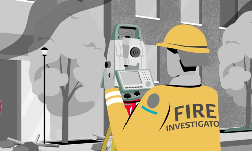
After the scene has been secured and the fire extinguished, the emergency teams begin their work. But utmost care is necessary because damaged buildings often collapse. So to ensure the safety of everyone on the scene, Leica Geosystems Total Stations can be deployed. After assessing the extent of the damage to the buildings and the area that needs to be monitored, the fire unit’s commander and the total station operator decide where the stations will be placed and what parts of the structure they are going to monitor. Leica Geosystem’s robotic Total Stations continuously observe the previously defined reference points on the damaged structure in predefined time intervals and are equipped with an alarm that will be triggered if any part of the structure starts to move. Suitable solutions for this task are the Leica TS16 with onboard Leica Captivate software. Alternatively, Leica GeoMoS software can be paired with any compatible sensor system to detect structural movements 24/7 and automatically inform the responsible parties.
– IMMERSIVE –
The Forensic Digital Twin created on a fire scene allows investigating parties to do as many virtual site walk-throughs as they want, looking at the scene and evidence from different angles.
– DECISIVE –
Our fire and explosion investigation tools provide a solid basis for data-anchored decisions.
– PROTECTIVE –
Our tools allow you to collect evidence more quickly in hazardous environments without sacrificing accuracy and future investigative options. We also cover structural safety or chain of custody issues.
For more information please contact our Public Safety experts or visit our Public Safety, Security and Forensics website.
Author: David M. Taylor, soundswrite.ch
Editor: Malgorzata Krol, Public Safety, Security and Forensics, Hexagon Geosystems