


Detecting and mapping underground utilities are critical aspects of surveying, which provide intricate details of subsurface infrastructures, ensuring safer excavation and preventing accidental damage. Due to this importance, diversifying into utility detection services is a compelling opportunity for surveyors to enrich their portfolios, elevate competitiveness, and unlock new revenue streams.
This is the first blog in a series inviting surveyors to embark on a journey into utility detection and mapping. In this post, we’ll discuss starting small with entry-level solutions.
Start your journey: The Leica DSX Utility Detection Solution
The Leica DSX Ground Penetrating Radar (GPR) system is the bridge to your entry into the realm of utility detection. Fusing intuitive software with portable hardware, the Leica DSX amplifies productivity via automatic data analysis, instantaneously offering 3D utility maps.
You don’t need to be an expert in interpreting GPR data to operate the Leica DSX; its user-friendly interface ensures seamless and precise detection and mapping of underground utilities. Even in compressed and tricky areas, DSX enables you to scan without any hassle. Also, Leica DSX can be integrated with GNSS antenna for absolute positioning of the underground utility.
What’s better is that the immediate 2D/3D utility maps and high-resolution detection results are right there to expedite your onsite activities. The Leica DSX not only supports the creation of instant professional reports you can use and share but also helps establish reliable zones to avoid inadvertent damage.
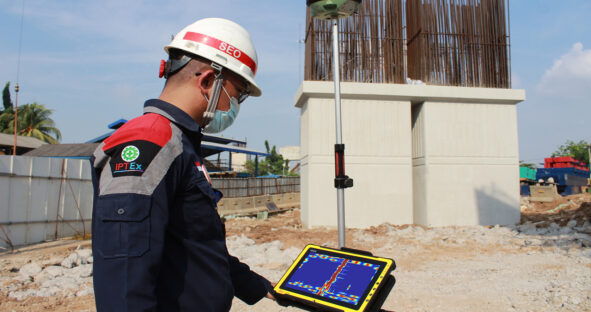
Leica DSX in action on the Becakayu Elevated Highway project, providing real-time utility detection to prevent accidents, improve safety, and increase construction efficiency.
As a testament to its efficiency, Waskita Karya, a leading Indonesian state company, successfully integrated the Leica DSX into its workflow during the construction of the Becakayu Elevated Highway. This tool enabled real-time, accurate detection of buried utilities like gas pipes and electric cables, thus facilitating safer construction and pillar placement. Additionally, the solution was easy to operate, requiring minimal training for the staff. As a result, the Leica DSX enabled safer construction practices and improved project efficiency, resulting in substantial time and cost savings.
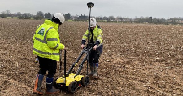
The Leica Geosystems DSX utility detection solution in use, providing J. Wilson Contractors Ltd with detailed, accurate 3D utility mapping to ensure safe and efficient excavations.
The Leica Geosystems DSX utility detection solution in use, providing J. Wilson Contractors Ltd with detailed, accurate 3D utility mapping to ensure safe and efficient excavations.Similarly, J. Wilson Contractors Ltd (JWC) diversified its service offerings using the Leica DSX. With the DSX, JWC can detect previously untraceable materials and provide clients with exact locations and depths. This technology allows JWC to offer detailed surveys to their clients and conduct safer excavations, thereby enhancing their service offerings. The implementation has contributed to increased interest and orders for the company, which plans to use this GRP in all future underground surveys.
Delve Deeper: Leica DS2000 Utility Detection Radar
For those seeking a more comprehensive approach to utility detection, the Leica DS2000 uncovers all potential threats, including non-conductive pipes and fibre optics, and significantly enhances site safety.
Equipped with a dual-frequency antenna, the Leica DS2000 can detect deep and shallow targets simultaneously. Integrated with its simple yet powerful software, this tool is efficient in data collection and storage, allowing for easy post-processing at your office. Its ergonomics allow comfortable manoeuvring around the most challenging sites. The Leica DS2000 can be combined with other Leica Geosystems equipment to form a utility detection powerhouse.
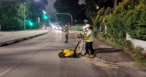
The Leica DS2000 in action, revolutionising HSC Pipeline Engineering’s underground utility surveys in Singapore, enhancing accuracy, saving time, and reducing costs.
Singapore’s HSC Pipeline Engineering successfully used the Leica DS2000 in their operations, demonstrating significant cost and resource savings and enhanced precision in underground mapping. Previously, utility surveys involved labour-intensive digging of trial holes, which was disruptive and costly. The transition to GPR allowed HSC to acquire underground data faster and non-destructively, covering larger areas than before. This reduced the need for trial hole digging by 30%, translating into significant cost savings and the reassignment of personnel to other revenue-generating activities. Moreover, the Leica DS2000 and the Leica GS18 T GNSS RTK rover combination is part of HSC’s plans to create a shared platform of underground data for better-informed decisions related to Singapore’s infrastructure maintenance and expansion.
Getting Started with Leica Geosystems Detection Solutions
Starting your journey into utility detection with Leica Geosystems is straightforward. Choose the solution that fits your needs – Leica DSX for an entry-level GRP solution or Leica DS2000 for a more comprehensive detection experience. Implementing these tools into your existing operations is practical and uncomplicated. With our committed support through every step, all potential concerns like training and software adaptation are competently addressed.
This blog begins a series and is followed by “Grow with Multichannel GPR for Underground 3D Mapping” and “Scale Up with Seamless Above and Below Ground Utility Mapping Solution“. Read the subsequent posts and expand your journey into utility mapping and detection for maximised productivity and profitability.