


Unforeseen encounters with buried utilities can cause delays, increase expenses, and endanger the safety of construction crews. Surveying professionals increasingly provide utility detection and mapping services for both subterranean utilities and above-ground structures, creating safer construction environments, saving time, and reducing costs.
This third and final entry in our blog series continues our journey into utility detection and mapping services. Previous posts have explored how entry-level solutions like the Leica DSX can provide a springboard into this field and how multichannel Ground-Penetrating Radar (GPR) systems like Stream DP can deliver comprehensive underground mapping. This blog focuses on how mobile above and below-ground data acquisition can propel your surveying services to the forefront of utility mapping and detection.
Accelerating Utility Detection and Mapping Services with GPR & LiDAR data
Stream UP is our flagship GPR system specifically for mapping utilities over expansive areas. This vehicle-mounted solution combines a multi-frequency, multi-channel, double-polarised sensor attached to a mobile framework, enabling the seamless coverage of large areas. This advanced utility mapping solution significantly streamlines the entire process — from pre-data acquisition logistics to interpretation and extraction in the post-processing stage.
Unlike other GPR systems that are large, cumbersome, and often require special permits for operation, IDS GeoRadar’s Stream UP features an easy-to-assemble design for easy and safe transportation. The benefits don’t stop there: Stream UP systems can be easily combined with the Leica Pegasus TRK mobile mapping systems to deliver synchronised data acquisition of GPR, LiDAR and camera intelligence with a collection speed of up to 60 km/h. This integrated solution enables large-scale infrastructure measurement of geospatial assets above and below the ground and digital twin creation.
Let’s examine real-world cases of breakthroughs to better illustrate Stream UP’s transformative power.
Creating New Standards in Safety and Efficiency with Stream UP in Singapore’s Pipeline Projects
HSC Pipeline Engineering Pte Ltd, a frontrunner in Singapore’s pipeline projects, adopted Stream UP to provide a comprehensive and accurate 3D overview of utilities beneath the city’s surface. Stream UP has been instrumental in accurately detecting and mapping underground utilities while on the move, collecting essential data for utility projects to be planned and executed without disrupting city traffic.
The lightweight and adaptable nature of Stream UP dramatically eases the setup process, requiring only two people for transportation and assembly and a single operator for control. The system operates in complete absence of contact with the ground, reducing physical stress on the system and, consequently, maintenance overheads.
Since introducing Stream UP to their operations, HSC has managed to minimise excavation disruptions, save on costs, and boost productivity significantly. A traditional trench survey approach allows vision of only 3.3% of the entire operation theatre, whereas, with Stream UP, HSC has been able to cover 100% of the intended survey area without excavation.
Hence, with Stream UP, safety, operational efficiency, and cost-effectiveness have become the new standard for HSC and utility mapping and detection services across Singapore.
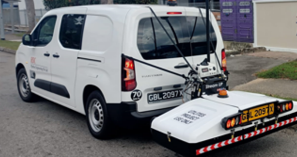
HSC Pipeline Engineering Pte Ltd utilises Stream UP for comprehensive and accurate utility detection.
Flexible Service Offering Through GPR & Mobile Mapping: The Severn Partnership Success Story
Severn Partnership, a geospatial company operating for nearly 40 years, is an excellent case study illustrating the benefits of adopting advanced tech solutions like Stream UP and Leica Pegasus:Two Ultimate mobile mapping system. Their investment in these technologies has placed them at the forefront of the spatial markets, enhancing their reputation and enabling them to offer more precise and efficient services.
Stream UP and Pegasus:Two Ultimate have allowed Severn Partnership to radically enhance their data collection, processing, and delivery capabilities. This transition has not only attracted new clients due to the efficiency and safety improvements but also allowed a much more flexible service offering capable of delivering both 3D and simpler 2D data visuals.
Furthermore, adopting this technology has opened doors to larger projects and diversified clients. No longer limited to traditional surveying, the company is now participating in civil engineering, construction work, and even unique projects like scanning racetracks for Formula E.
Watch the video below to learn more about Severn Partnership’s journey leveraging this GPR and LiDAR technology.
Unleashing New Opportunities in Utility Detection and Mapping
In conclusion, Stream UP redefines utility detection and mapping, transcending traditional capabilities to offer a solution that enhances accuracy, speed, and reliability. Its unparalleled ability to synchronise with Leica Pegasus TRK mobile mapping systems allows for comprehensive scans of both below and above-ground surfaces. This solution sets new benchmarks in utility detection and mapping, reshaping industry expectations for precision, efficiency, and overall performance.
As we navigate a demanding landscape where on-time project completion, cost minimisation, and impeccable safety records are demanded, Stream UP emerges as an essential partner for surveyors. It simplifies utility detection and mapping services, fosters business growth, and offers surveying service providers a way to diversify their offerings, tap into new revenue streams, and maintain competitiveness.
We hope this blog series has highlighted the potential benefits of adopting GPR technology and that you are inspired to embark on your journey into the world of utility detection and mapping.