


Utility detection and mapping is an essential service in today’s world, which is filled with complex and evolving infrastructure. It is crucial in ensuring safety during excavation, minimising risks, and preventing infrastructural damage that could result in service disruption or financial loss. Due to increased demand, providing utility detection services to industries such as building construction, energy, telecommunications, and archaeology or conservation represents a significant business opportunity.
Utility detection and mapping services is a growing opportunity for surveyors. Key to achieving this expansion is acquiring cutting-edge technological solutions, such as Stream DP, a state-of-the-art Ground Penetrating Radar (GPR) array solution.
This is the second blog in a series inviting surveyors to embark on a journey into utility detection and mapping. In this post, we’ll discuss how a multichannel GPR can drive your business into new dimensions of 3D mapping.
Why Stream DP is the Next Big Step in Utility Mapping
Stream DP is a top-performing tool for underground surveys. It uses breakthrough technology, known as Equalized scrambled Technology (EsT), developed by IDS GeoRadar. This allows the detection of hidden underground features deeper than other solutions on the market and facilitates the creation of exclusion zones for specific utilities. Furthermore, the 3D maps created can be readily integrated into machine control systems, ensuring precise operations and the safety of field personnel.
Stream DP’s high productivity, efficiency, and usability unlock new potentials for surveyors, giving them a competitive edge in the thriving utility detection market.
Let’s plunge into some real-world endeavours to help comprehend the tangible advantages of incorporating Stream DP into your business.
Successful Projects in Underground Mapping Across Germany, Austria, and Switzerland
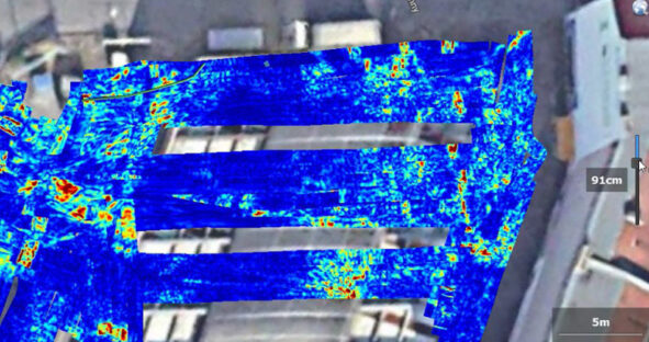
SUBTERRA GMBH, a consulting company specialising in underground utility detection, employed Stream DP’s innovative EsT technology for utility mapping and exploration in Germany, Austria, and Switzerland. It helped determine underground lines with utmost precision, securing comprehensive maps in 2D and 3D formats.
One project involved mapping a village’s underground utilities for the performance of fibre optics installation. In the three-day survey, 34 km was mapped, resulting in cost savings and ensuring worker safety by reducing soil verification spots from 43 to just 8.
Another investigation included mapping underground lines and pipes in Stuttgart city centre to install a new transformer station, part of Germany’s transition to renewable energy. The lightweight and easy-to-handle Stream DP allowed quick surveys over large spaces across various terrains.
Finally, for a petrol station in Berlin, SUBTERRA conducted a detailed analysis to help the client decide where to drill about 40 cores to take gasoline samples. In every case, Stream DP and IQMaps GPR data analysis software proved to be crucial tools for non-invasive and efficient underground mapping.
SUBTERRA GMBH used IQMaps software to conduct non-invasive, detailed underground utility mapping at a Berlin petrol station, which is crucial in transitioning towards new fuelling methodologies.
A Case for Technological GPR Innovation in Conservation
In a novel conservation initiative, Subsurface Mapping Solutions (SMS), in collaboration with the Australian Wildlife Conservancy and Wombat Foundation, made use of Stream DP’s GPR technology to map the burrows of the critically endangered northern hairy-nosed wombat. The project highlighted the powerful, non-invasive capabilities of GPR in ecological preservation. This case demonstrates the adaptability of GPR technology, moving beyond urban landscapes into conservational efforts, underscoring its potential as a valuable tool for safeguarding vulnerable species.
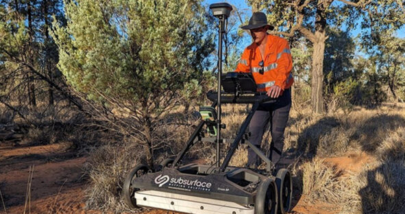
Stream DP array being used for burrow mapping in the Richard Underwood Nature Refuge. This project highlights an innovative use case for GPR technology in conservation, emphasising how GPR can protect endangered species.
Railway Underground Surveys Made Simple with Stream DP
In a challenging rail survey project, Boviar, an Italian engineering company, selected Stream DP as their tool of choice for surveying rugged, trackside terrain. Stream DP outperformed competitors by offering up to 60% greater depth penetration. Post-processing software IQMaps complemented Stream DP, enabling the development of detailed, accurate subterranean maps extending to depths of three meters, successfully showcasing GPR effectiveness in rail infrastructure management. Furthermore, Stream DP’s quick assembly, lightweight design, and low power consumption ensured optimal performance even in difficult conditions.
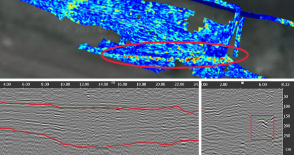
Stream DP was employed by Boviar during a complex survey near a railway line. Stream DP’s advanced technology, manoeuvrability, and lightweight design facilitated accurate underground mapping, even in rugged terrains.
Broadening Your Service Portfolio with Utility Detection Tech
As an investment, Stream DP delivers unique returns. Its application amplifies detection services, offering paramount safety and cost savings, as validated by SUBTERRA GMBH and the railway surveying project by Boviar, where Stream DP’s capabilities facilitated efficient rail infrastructure management. The versatility of Stream DP also opened new service areas by contributing to wildlife conservation efforts—a testament to the product’s adaptability. With utility detection being an exponentially growing market, Stream DP is an effective business decision for companies aiming to diversify their service portfolio and scale their operations.
This blog trilogy is preceded by “Entry-Level Solutions for Utility Detection and Mapping” and ends with “Scale Up with Seamless Above and Below Ground Utility Mapping Solution“. Read on to fully immerse yourself in the world of utility detection and mapping to optimise productivity and profitability.