


Leica Geosystems tilt technology was introduced in 2018, and has been a game-changer for measuring and staking out. Tilt technology replaces the often frustrating process of manually levelling a pole with a circular bubble. Manual levelling takes time, particularly in stakeout where it needs to be repeated over and again. Holding a pole vertically can also be inaccurate and is subject to human error. Tilt technology allows you to measure a point in a radically different way without worrying about the verticality of the pole. Here we explain how it works and look at its benefits – especially in heavy construction – including ease of use, greater accuracy and increased productivity.
What is tilt technology?
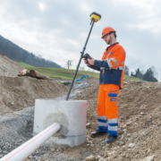
![]() Leica Geosystems’ tilt technology is a tilt compensation feature for GNSS smart antennas. With this technology, you can measure points without the need to keep the pole level. The technology – available on the Leica iCON gps 70 T – combines GNSS and IMU technology (inertial measurement unit) to detect the tilt and orientation of a pole that are automatically fully compensated. To accurately measure a point, you place the tip of the pole at the position you want to measure and the smart antenna will calculate the tip position regardless of the pole’s tilt.
Leica Geosystems’ tilt technology is a tilt compensation feature for GNSS smart antennas. With this technology, you can measure points without the need to keep the pole level. The technology – available on the Leica iCON gps 70 T – combines GNSS and IMU technology (inertial measurement unit) to detect the tilt and orientation of a pole that are automatically fully compensated. To accurately measure a point, you place the tip of the pole at the position you want to measure and the smart antenna will calculate the tip position regardless of the pole’s tilt.
Tilt technology solves the problem of needing to manually check that measuring poles are vertical. When measuring points without tilt technology, it is essential to keep the pole at 90 degrees to the ground. This is because the target point is based on the calculated GNSS position of the antenna reference point and the pole’s length, which is assumed to be straight down from the rover. If your pole is tilted and the antenna has an offset to the point you want to measure, the measurement will still be taken vertically and will be at a different position to the one you are pointing with the pole tip. Making sure a pole is levelled – using a bubble as your guide – is fiddly, takes time and practise to get right and carries a risk of inaccuracy. Here is also important to mention that the level bubble has its own accuracy which is lower than the tilt technology. Therefore, by using Leica Geosystems’ tilt technology, there is an accuracy increase but also in speed, which we look into in the following section.
Measure and stakeout points faster than ever before
This tilt technology simplifies and makes the job of measuring and staking out points much quicker, as the operator does not waste any more time to ensure that the pole is vertical. From comparative measurements and anecdotal evidence from our customers, you can be up to 30% faster. Some customers even report a time saving, when measuring points, to up to 50%. Being able to measure more points in a shorter time is a major boost to productivity and can give you a competitive advantage over other companies who need to allow more time in their estimate to complete the same task. Additionally, the iCON gps 70 T can be used even by employees that have no previous experience with measuring tasks, providing peace of mind to foremen that the risk of wrong measurements is eliminated. In the following video, you can see a simple representation of the time savings and efficiency gains, by working with a tilt-compensated antenna, versus an antenna that requires levelling the pole on every single point. Jasmin on the left with the iCON gps 30 (without tilt compensation) and Evi on the right with the iCON gps 70 T are measuring points that are 5 m apart and illustrate this time difference. Imagine you have to measure 100 or even more points a day…
Now, you can measure points that weren’t accessible before with your rover pole. It is not always possible to hold the pole vertically on a target point such as house/building corners, obstructed or elevated points. In the past, time-consuming alternative measurement methods were required to get such a point measured. However, with the Leica tilt technology, this doesn’t matter and they can be measured as quickly and precise as any other point.
Always accurate, without calibration
Leica Geosystems’ tilt technology is easy to use since cumbersome and time-consuming calibration routines are not required. The iCON gps 70 T tilt technology uses an inertial measurement unit (IMU) to determine the attitude of the pole in real-time. As this technology is completely resistant and immune to any magnetic disturbance, it is fully calibration and service-free. Consequently, the iCON gps 70T works straight out of the box. With a conventional pole, the level bubble attached to the pole will need to be calibrated at the point of purchase and regularly to make sure that the vertical axis indicator is operating correctly. Poles often get dropped and damaged and any damage to the indicator will mean that measurements taken with that pole are unreliable. But let’s be honest, not everybody does that. Even the most experienced surveyor can’t make an incorrect instrument take correct measurements. The Leica iCON gps 70 T eliminates the error of a misaligned bubble.
Permanent tilt compensation speeds up significantly the measurement process and extends the measurement possibilities on any construction site while improving the quality and accuracy of the collected data. For more information about tilt technology and the Leica iCON gps 70 Series visit our website or contact your local Leica Geosystems representative!
 Matthias Schmidt
Senior Product Portfolio Manager
Machine Control Division
Leica Geosystems AG