


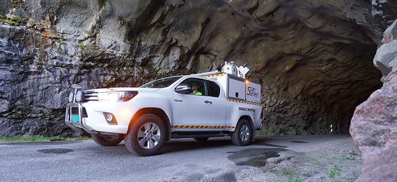
Bård Hauan Andersen has been operating reality capture technology at Norway-based Scan Survey since 2017, carrying out projects for surveying, mapping, geographic information system (GIS) and 360-street images in Europe. In this guest blog, Andersen explains why Scan Survey was one of the first companies in the world to own and operate the Leica Pegasus:Two mobile mapping solutions for capturing accurate and precise spatial data and images.
 Conquering challenges to put Europe on the map
Scan Survey’s most significant requirement is accuracy. With assignments including tunnels, construction sites, city streets, railway tracks, roads, buildings and parks, our projects often need absolute accuracy below three centimetres and 0.5 centimetres of relative accuracy. This can be a challenge; for example, accuracy is prone to drift when capturing inside tunnels for a long time, even when using an Inertial Navigation System (INS).
We were looking for a reality capture solution that was not only portable and convenient but also improved the accuracy we could achieve and increased our capabilities across all areas of scanning. After researching options, Pegasus:Two was the most accurate and fastest solution for our projects.
Tunnel surveying and extensive road network surveying have become much easier for the team to perform using the Pegasus:Two. They can capture the terrain with more accuracy, there’s a lower margin of error and, operations take less time to perform – the team can mount it on a car and other modes of transportation, such as boats or trains, and mobilise it in a short period.
To prevent accuracy drift inside tunnels, the team uses Ground Control Points (GCP) – objects found in the point cloud from the Pegasus:Two – to correct the accuracy during post-processing. When used outside, the Global Navigation Satellite System (GNSS) becomes the main factor for absolute navigation, and the INS plays a part in providing relative accuracy when GNSS isn’t available.
Scan Survey has a specialised workflow to keep the company ahead of our competitors. The team utilises many software programmes to perform quality checks on our projects, and streamline the flow of data. In the field, we use Mobile Data Acquisition (MDA), and a master base for differential GNSS. In the office, the team post-process data using the Leica Pegasus:Manager to visualise the navigation, point cloud and 360 pictures. By using a specialised workflow and a mixture of custom and Leica Geosystems software, we can provide superior accuracy for our customers.
 Investing in reality capture technology to meet customer requirements
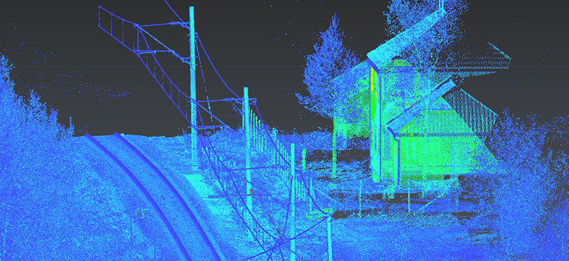
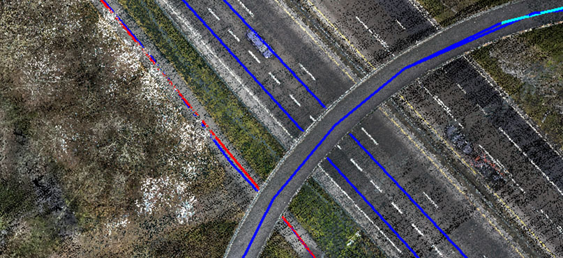
The Pegasus:Two’s scans provide a georeferenced, coloured point cloud that is processed and quality-assured before data is incorporated into the 3D model. Pictures are taken with an integrated camera system which is calibrated with laser scanners. The images and the point cloud are synchronised and can be used together in advanced GIS tools.
It captures up to two million points per second, allowing us to gather more of the surrounding environment when compared to traditional surveying equipment, such as total stations. It enables our customers to choose the objects they want to focus on and digitise them at a later stage, providing added flexibility to go the extra mile.
The Pegasus:Two is also cost-efficient. There is no need for us to contact agencies to receive access to sites for gathering data – we can drive on roads and through tunnels and facilities in one pass, not requiring to stop and close the sites to do multiple static scans. This reduces legal requirements in certain European countries, such as Norway.
 Operating the Leica Pegasus:Two with expertise
As Pegasus:Two captures crucial data, our operatives at Scan Survey require specialist knowledge in geomatics to deliver the best results for our customers. With this in mind, our mobile mapping operators must have completed a degree in Master of Science in Geomatics and one year of data processing and fieldwork training. After completing these essential steps, we feel that our engineers are sufficiently trained to operate the Pegasus:Two.
Utilising this expertise, our team have used Pegasus:Two in large projects for the national road and rail agencies. It has allowed us to become competitive on larger terrain models and projects over several square kilometres. The data it collects is so detailed we have even developed a street view with it. It puts Scan Survey in a great position as demand increases for point clouds, terrain models and 360-images on Europe’s big projects in transport planning.

Bård Hauan Andersen
M.Sc. Geomatics
To learn more, visit the Scan Survey website.
For more information about the Leica Pegasus:Two mobile mapping solution, visit our product page. Alternatively, please browse our range of mobile capture on our website.